Saint-Benoist-sur-Mer
| Saint-Benoist-sur-Mer | ||
|---|---|---|
|
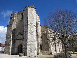
The church of Saint-Benoît, in Saint-Benoist-sur-Mer | ||
| ||
 Saint-Benoist-sur-Mer | ||
|
Location within Pays de la Loire region  Saint-Benoist-sur-Mer | ||
| Coordinates: 46°25′28″N 1°21′12″W / 46.4244°N 1.3532°WCoordinates: 46°25′28″N 1°21′12″W / 46.4244°N 1.3532°W | ||
| Country | France | |
| Region | Pays de la Loire | |
| Department | Vendée | |
| Arrondissement | Les Sables-d'Olonne | |
| Canton | Moutiers-les-Mauxfaits | |
| Intercommunality | Pays moutierrois | |
| Government | ||
| • Mayor (2008–2014) | Daniel Neau | |
| Area1 | 15.53 km2 (6.00 sq mi) | |
| Population (2006)2 | 344 | |
| • Density | 22/km2 (57/sq mi) | |
| Time zone | CET (UTC+1) | |
| • Summer (DST) | CEST (UTC+2) | |
| INSEE/Postal code | 85201 / 85540 | |
| Elevation | 1–26 m (3.3–85.3 ft) | |
|
1 French Land Register data, which excludes lakes, ponds, glaciers > 1 km² (0.386 sq mi or 247 acres) and river estuaries. 2 Population without double counting: residents of multiple communes (e.g., students and military personnel) only counted once. | ||
.svg.png)
Saint-Benoist-sur-Mer is a commune (or Saint-Benectict-super-mare) in the Vendée department in the Pays de la Loire region in western France.
Geography
The river Lay forms most of the commune's south-eastern border.
See also
References
| Wikimedia Commons has media related to Saint-Benoist-sur-Mer. |
This article is issued from Wikipedia - version of the 10/17/2015. The text is available under the Creative Commons Attribution/Share Alike but additional terms may apply for the media files.