Saint-Avit, Lot-et-Garonne
| Saint-Avit | |
|---|---|
|
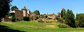
A general view of Saint-Avit | |
 Saint-Avit | |
|
Location within Nouvelle-Aquitaine region  Saint-Avit | |
| Coordinates: 44°34′08″N 0°12′48″E / 44.5689°N 0.2133°ECoordinates: 44°34′08″N 0°12′48″E / 44.5689°N 0.2133°E | |
| Country | France |
| Region | Nouvelle-Aquitaine |
| Department | Lot-et-Garonne |
| Arrondissement | Marmande |
| Canton | Seyches |
| Intercommunality | Pays du Trec et de la Gupie |
| Government | |
| • Mayor (2008–2014) | Michel Couzigou |
| Area1 | 8.95 km2 (3.46 sq mi) |
| Population (1999)2 | 152 |
| • Density | 17/km2 (44/sq mi) |
| Time zone | CET (UTC+1) |
| • Summer (DST) | CEST (UTC+2) |
| INSEE/Postal code | 47231 / 47350 |
| Elevation |
45–123 m (148–404 ft) (avg. 103 m or 338 ft) |
|
1 French Land Register data, which excludes lakes, ponds, glaciers > 1 km² (0.386 sq mi or 247 acres) and river estuaries. 2 Population without double counting: residents of multiple communes (e.g., students and military personnel) only counted once. | |
Saint-Avit is a commune in the Lot-et-Garonne department in south-western France.
See also
References
| Wikimedia Commons has media related to Saint-Avit (Lot-et-Garonne). |
This article is issued from Wikipedia - version of the 3/16/2015. The text is available under the Creative Commons Attribution/Share Alike but additional terms may apply for the media files.