Saillat-sur-Vienne
| Saillat-sur-Vienne | |
|---|---|
|
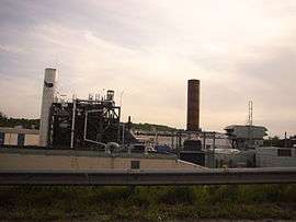
The International Paper factory, in Saillat-sur-Vienne | |
 Saillat-sur-Vienne | |
|
Location within Nouvelle-Aquitaine region  Saillat-sur-Vienne | |
| Coordinates: 45°52′22″N 0°49′01″E / 45.8728°N 0.8169°ECoordinates: 45°52′22″N 0°49′01″E / 45.8728°N 0.8169°E | |
| Country | France |
| Region | Nouvelle-Aquitaine |
| Department | Haute-Vienne |
| Arrondissement | Rochechouart |
| Canton | Saint-Junien-Ouest |
| Intercommunality | Vienne Glane |
| Government | |
| • Mayor (2008–2014) | René Charles |
| Area1 | 6.29 km2 (2.43 sq mi) |
| Population (2006)2 | 842 |
| • Density | 130/km2 (350/sq mi) |
| Time zone | CET (UTC+1) |
| • Summer (DST) | CEST (UTC+2) |
| INSEE/Postal code | 87131 / 87720 |
| Elevation | 153–254 m (502–833 ft) |
|
1 French Land Register data, which excludes lakes, ponds, glaciers > 1 km² (0.386 sq mi or 247 acres) and river estuaries. 2 Population without double counting: residents of multiple communes (e.g., students and military personnel) only counted once. | |
Saillat-sur-Vienne (French pronunciation: [sajasyʁvjɛn]; Occitan: Salhac, pronounced [saˈʎak, saˈjak], locally: [ʃɔˈjak]) is a commune in the Haute-Vienne department in the Nouvelle-Aquitaine region in west-central France. Because of how the town's name is pronounced in its native tongue: [ʃɔˈjak], Saillat was formerly known as Chaillac.[1]
Inhabitants are known as Saillatais.
See also
References
Notes
- ↑ Gustave Vapereau (1819-1906), Atlas géographique, statistique et historique des départements de la France, 1867, p. 182
| Wikimedia Commons has media related to Saillat-sur-Vienne. |
This article is issued from Wikipedia - version of the 11/11/2016. The text is available under the Creative Commons Attribution/Share Alike but additional terms may apply for the media files.