Sahuayo
| Sahuayo Tzacuātlayotl (Nahuatl) | ||
|---|---|---|
 | ||
| ||
| Nickname(s): Athens of Michoacán | ||
| Motto: Nation, Justice, Progress | ||
 | ||
| Coordinates: 20°3′N 102°44′W / 20.050°N 102.733°W | ||
| Country | Mexico | |
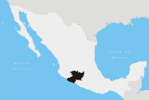
| State | Michoacán | |
| Boroughs |
La Yerbabuena Rincón de San Andrés La Puntita Cerrito Pelon | |
| Foundation | 1530 | |
| Government | ||
| • Type | Municipality | |
| Area | ||
| • Total | 128.05 km2 (49.44 sq mi) | |
| Elevation | 1,561 m (5,121 ft) | |
| Population | ||
| • Total | 59,316 city; 61,965 municipality (2,005 census) | |
| Time zone | CST UTC-6 | |
| • Summer (DST) | CDT UTC-5 (UTC) | |
| Postal Code | 59000 | |
| Area code(s) | +52 (Mexico) / +353 (Sahuayo) | |
Sahuayo (Nahuatl: Tzacuātlayotl) is a city in the state of Michoacán, in western México, near the southern shore of Lake Chapala. It serves as the municipal seat for the surrounding municipality of the same name. Sahuayo was an important center for the Cristero War or "La Cristiada" and the city always has been an active center of commerce for the Chapala lake region, specially crafts, sandals (huaraches), hats (sombreros), made by Sahuayenses. The name means "turtle shaped pot " it has been called the Athens of Michoacán because of its many important poets, writers and painters. Today it is the seat for Arts propositions Association. The city had a 2005 census population of 59,316 persons, while the municipality had a population of 61,965. The area of the municipality is 128.05 km² (49.44 sq mi).
The celebration each July 25 of El Patrón Santiago or Saint James the Great and the dancing Tlahualiles are internationally recognized. The sister city of Sahuayo is Lancaster, California, United States, where it is one of 3 Californian cities where residents from Sahuayo moved to in the 2000s. The city of Santa Ana, California is known as Little Sahuayo because of the high number of residents who hail from Sahuayo. Another community is Indio, California where large numbers of residents from Sahuayo moved to.
Location

Sahuayo is located to the northwest of the State, at the coordinates 20º03' north latitude and 102º44' west longitude, 1,530 meters above sea level. To the north of the Sahuayo border one finds Venustiano Carranza (also known as San Pedro), to the east Villamar, to the south Jiquilpan, and Cojumatlán de Régules to the northwest. Its distance to the State Capital, Morelia, is 215 km. The name Sahuayo comes from the Nahuatl language, and is interpreted in many ways. According to the philologist and lawyer Cecilio A. Róbelo, it means "in where gives the scabies"; according to the Dr. "Don" Antonio Peñafiel, the word is made up of two elements: tzacuātl and ayotl, where tzacuātl (pot) is a vase formed by one half of a coconut and "ayotl," which translates into "turtle"; hence vessel turtle or vessel that has the aspect of a turtle.
Seal

The first field appears a turtle on stone in arrogant attitude, that represents the foundation of Sahuayo by people of the same characteristics, year of 1530. In background to the bottom, three hills stand out at sight, that mean according to the tradition, the three towns that gave origin to Sahuayo, in the second half of the 16th century, also according to the intention of the designer can be considered the three governments: federal, state and municipal. In the third field a plumed serpent or Quetzalcoatl god of the Mexicans is observed fighting with the cross whose fundamental meaning is not other that the definitive conquest of Sahuayo, made by Nuño Beltrán de Guzmán. In the fourth field of the municipal shield it appears a tree and a star absolutely including in the tree to the town of Sahuayo unifying it, symbolizing the root of their people. Finally with indelible signs they appear in the contour of the shield, printed three sacred words: “Patria, Justicia y Progreso” (Nation, Justice and Progress), moral values that deserve respect and joint operation to us.
Cuisine
Sahuayo is famous for its typical food such as carnitas, dry birria, and tacos al pastor. their traditional breads like tranca and the cemita usually are usually accompanied by milk, atole, or any other hot drink.
Notable residents
- Hector Fajardo – Major League Baseball player
- Lilia Prado – actress
- Saint José "Joselito" Sánchez del Río – martyr of the Cristero War, canonized by Pope Francis in October, 16, 2016.
References
- Link to tables of population data from Census of 2005 INEGI: Instituto Nacional de Estadística, Geografía e Informática
- Michoacán Enciclopedia de los Municipios de México
Government pages
- Negotiating Extra-Territorial Citizenship: Mexican Migrants and the Transborder Politics of Community
- (Spanish) Government Page
City information
- Tourist information
- Semanario Tribuna Sahuayo's Newspaper
Coordinates: 20°03′N 102°44′W / 20.050°N 102.733°W