Sagarmatha National Park
| Sagarmatha National Park | |
|---|---|
|
IUCN category II (national park) | |
|
Entrance sign | |
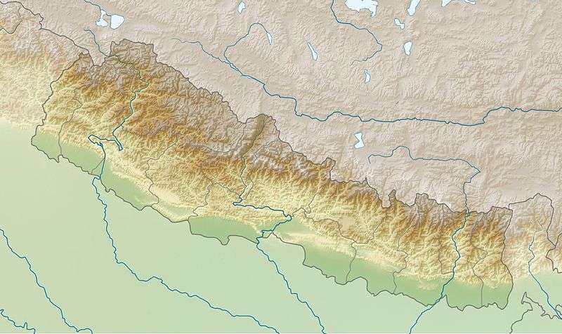 | |
| Location | Nepal |
| Coordinates | 27°56′N 86°44′E / 27.933°N 86.733°ECoordinates: 27°56′N 86°44′E / 27.933°N 86.733°E |
| Area | 1,148 km2 (443 sq mi) |
| Established | July 19, 1976 |
| Type | Natural |
| Criteria | vii |
| Designated | 1979 (3rd session) |
| Reference no. | 120 |
| State Party |
|
| Region | Asia-Pacific |

The Sagarmāthā National Park (sagaramāthā rāṣṭriya nikuñja) is a protected area in the Himalayas of eastern Nepal that is dominated by Mount Everest. It encompasses an area of 1,148 km2 (443 sq mi) in the Solukhumbu District and ranges in elevation from 2,845 to 8,848 m (9,334 to 29,029 ft) to at the summit of Mount Everest. In the north, it shares the international border with the Qomolangma National Nature Preserve of Tibet and extends to the Dudh Kosi river in the south. Adjacent to the east is the Makalu Barun National Park.[1]
Sagarmāthā is a Nepali word derived from सगर् sagar meaning "sky" and माथा māthā meaning "head".[2]
The protected area has been identified as an Important Bird Area by BirdLife International and is included in the Sacred Himalayan Landscape.[3]
History
The Sagarmatha National Park was established in 1976. In 1979, it became the country's first national park that was inscribed as a Natural World Heritage Site. In January 2002, a Buffer Zone comprising 275 km2 (106 sq mi) was added.[1] Under the Buffer Zone Management Guidelines the conservation of forests, wildlife and cultural resources received top priority, followed by conservation of other natural resources and development of alternative energy.[4]
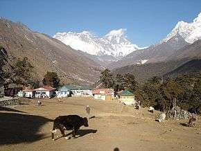
Tourism to the area began in the early 1960s. In 2003, about 19,000 tourists arrived. About 3500 Sherpa people live in villages and seasonal settlements situated along the main tourist trails.[5] The park's visitor centre is located at the top of a hill in Namche Bazaar, where a company of the Nepali Army is stationed for protection of the park. The park's southern entrance is a few hundred metres north of Monzo at 2,835 m (9,301 ft), a one-day trek from Lukla.
Landscape
The park contains the upper catchment areas of the Dudh Kosi river, Bhotekoshi river basin and the Gokyo Lakes. It is largely composed of rugged terrain and gorges of the high Himalayas, ranging from 2,845 m (9,334 ft) at Monjo to the top of the world's highest peak Sagarmatha (Mt. Everest) at 8,848 m (29,029 ft) above sea level. Other peaks above 6,000 m (20,000 ft) are Lhotse, Cho Oyu, Thamserku, Nuptse, Amadablam and Pumori. Barren land above 5,000 m (16,000 ft) comprises 69% of the park while 28% is grazing land and the remaining 3% is forested. Climatic zones include a forested temperate zone, a subalpine zone above 3,000 m (9,800 ft), and an alpine zone above 4,000 m (13,000 ft) that constitutes the upper limit of vegetation growth. The nival zone starts at 5,000 m (16,000 ft).[1]
Vegetation
In the lower forested zone, birch, juniper, blue pines, firs, bamboo and rhododendron grow. Above this zone the vegetation is dwarf-sized or comprises shrubs. As the altitude increases, plant life is restricted to lichens and mosses. Plants cease to grow at about 5,750 m (18,860 ft), because this is the permanent snow line in the Himalayas.
Forests of pine and hemlock cover the lower elevations of the national park. At elevations of around 3,500 m (11,500 ft) and above, forests of silver fir, birch, rhododendron and juniper trees are found.
Fauna
The forests provide habitat to at least 118 species of birds, including Himalayan monal, blood pheasant, red-billed chough, and yellow-billed chough. Sagarmāthā National Park is also home to a number of rare mammal species, including musk deer, snow leopard, Himalayan black bear and red panda. Himalayan thars, langur monkeys, martens and Himalayan wolves are also found in the park.
The temperature and available oxygen decrease with altitude. Therefore, the species living at high altitudes are adapted to living on less oxygen and cold temperatures. They have thick coats to retain body heat. Some of them have shortened limbs to prevent loss of body heat. Himalayan black bears go into hibernation in caves during the winter when there is no food available.
References
- 1 2 3 Bhuju, U. R., Shakya, P. R., Basnet, T. B., Shrestha, S. (2007). Nepal Biodiversity Resource Book. Protected Areas, Ramsar Sites, and World Heritage Sites. International Centre for Integrated Mountain Development, Ministry of Environment, Science and Technology, in cooperation with United Nations Environment Programme, Regional Office for Asia and the Pacific. Kathmandu, Nepal. ISBN 978-92-9115-033-5
- ↑ Turner, R. L. (1931). सगर् sagar and माथा matha in: A comparative and etymological dictionary of the Nepali language. K. Paul, Trench, Trubner, London.
- ↑ "Sacred Himalayan Landscape". Government of Nepal – Department of National Parks and Wildlife Conservation. Retrieved 23 February 2013.
- ↑ Heinen, J. T. and J. N. Mehta (2000). Emerging Issues in Legal and Procedural Aspects of Buffer Zone Management with Case Studies from Nepal. Journal of Environment and Development 9 (1): 45–67.
- ↑ Byers, A. (2005). Contemporary human impacts on Alpine ecosystems in the Sagarmatha (Mt. Everest) national park, Khumbu, Nepal. Annals of the Association of American Geographers 95 (1): 112–140.
Further reading
- Jefferies, M. (1991). Mount Everest National Park, Sagarmatha Mother of the Universe. Seattle: The Mountaineers. 192 pp.
External links
- Information of Department of National Parks and Wildlife Conservation, Nepal
- Official UNESCO website entry
- The World at Night: Everest and Mysterious Star
 | ||
| Wikimedia Commons has media related to World Heritage Sites in Nepal. |
| Wikimedia Commons has media related to Sagarmatha National Park. |