Sørsdal Glacier
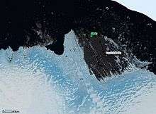
Sørsdal Glacier (68°41′S 78°15′E / 68.683°S 78.250°ECoordinates: 68°41′S 78°15′E / 68.683°S 78.250°E) is a heavily crevassed glacier, 15 nautical miles (28 km) long, flowing westward along the south side of Krok Fjord and the Vestfold Hills and terminating in a prominent glacier tongue at Prydz Bay. Discovered in February 1935 by a Norwegian expedition under Captain Klarius Mikkelsen and named for Lief Sørsdal, a Norwegian dentist and a member of the party from the whaling ship Thorshavn that landed at the northern end of the Vestfold Hills.[1][2]
The Sørsdal Glacier Tongue (68°42′S 78°0′E / 68.700°S 78.000°E) is the prominent seaward extension of Sørsdal Glacier into Prydz Bay.[3]
References
- ↑ "Sørsdal Glacier". Geographic Names Information System. United States Geological Survey. Retrieved 2015-12-01.
- ↑ Norman, F.I.; Gibson, J.A.E.; Burgess, J.S. (October 1998). "Klarius Mikkelsen's 1935 landing in the Vestfold Hills, East Antarctica: some fiction and some facts". Polar Record. 34 (191): 293–304. doi:10.1017/S0032247400025985.
- ↑ "Sørsdal Glacier Tongue". Geographic Names Information System. United States Geological Survey. Retrieved 2015-12-01.
![]() This article incorporates public domain material from the United States Geological Survey document "Sørsdal Glacier" (content from the Geographic Names Information System).
This article incorporates public domain material from the United States Geological Survey document "Sørsdal Glacier" (content from the Geographic Names Information System).