São Joaquim
| São Joaquim | |||
|---|---|---|---|
| Municipality | |||
| Municipality of São Joaquim | |||
|
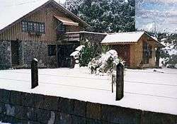
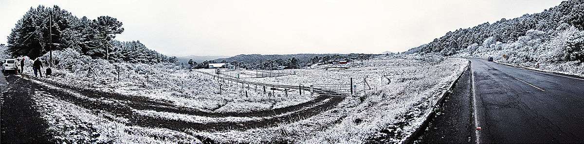
Snow in São Joaquim. | |||
| |||
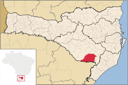 Location of São Joaquim | |||
| Coordinates: 28°17′38″S 49°55′55″W / 28.29389°S 49.93194°WCoordinates: 28°17′38″S 49°55′55″W / 28.29389°S 49.93194°W | |||
| Country | Brazil | ||
| Region | South | ||
| State | Santa Catarina | ||
| Founded | April 7, 1887 | ||
| Government | |||
| • Mayor | Newton Stelio Fontanella (PP) | ||
| Area | |||
| • Total | 1,885.608 km2 (728.037 sq mi) | ||
| Elevation | 1,360 m (4,460 ft) | ||
| Population (2009) | |||
| • Total | 25,122 | ||
| • Density | 12.3/km2 (32/sq mi) | ||
| [1] | |||
| Time zone | UTC-3 (UTC-3) | ||
| • Summer (DST) | UTC-2 (UTC-2) | ||
| HDI (2000) | 0.865 – high | ||
| Website | City Hall Website | ||

São Joaquim is a municipality in the state of Santa Catarina, situated in southern Brazil. It is located at latitude 28° 17' 38" south and longitude 49° 55' 54" west, with an altitude of 1,360 meters (4,460 ft). Its population in 2004 was 23,114 inhabitants. Located in the Planalto Serrano, it is located 136 km (85 miles) from Tubarão, 81 km (50 miles) from Lages and 227 km (141 miles) from Florianópolis. The town is home to a variety of ethnic groups, including Italian, Portuguese, Japanese and Afro- Brazilians, though composed mainly of descendants of German and Swedish immigrants. There is also a large proportation of the population from other states in Brazil, especially from Rio Grande do Sul.
Economy
The town's economy was once based on livestock, but recently the cultivation of temperate fruits such as apples has become more prominent. Today, São Joaquim is the largest producer of fruit in the state, with over 1000 small producers. Tourism is also important for the town, as it is one of the coldest places in Brazil and sometimes receives snowfall, a rather uncommon occurrence for the majority of Brazil (although refreezed snow, that by itself is not present in most of Brazil, seldom happens in many tropical areas as it does in about half of Southeastern Brazil). The town is also known for its wines, such as Villa Francioni, Joaquim, Quinta da Neve, Núbio and Suzin, which are reaching international recognition, especially in East Asia.
Geography and climate
Situated 1,353 meters above sea level, São Joaquim is one of the highest cities in the country, as the altitude of the seat of the municipality. The climate of the city is temperate (Cfb), with cool summers and low winter temperatures. The thermometer of the city reached −10 °C (14 °F) in the winter of 1991, making it the record-low temperature for the city. The national records are−14 °C (7 °F) in the municipality of Caçador and, unofficially, −17.8 °C (0 °F) in Morro da Igreja (Church Hill), in the neighboring municipality of Urubici. In summer the highest temperature ever recorded was 31.4 °C (89 °F). Along with Urupema in the state and São José dos Ausentes in Rio Grande do Sul, it is the coldest city of Brazil, with average annual temperature of 13 °C (55 °F). The hottest month is January with an average temperature of 17 °C (63 °F) while the coldest month is July with an average of 9 °C (48 °F). During the months of winter, frost is a common occurrence and occasionally, on colder days with heavy rainfall, snowfall is not uncommon. Due to the relatively low altitude of the city, the conditions are not usually conducive for there to be heavy snowfall or, indeed, for the snowfall to remain for very long.
| Climate data for São Joaquim (1961–1990) | |||||||||||||
|---|---|---|---|---|---|---|---|---|---|---|---|---|---|
| Month | Jan | Feb | Mar | Apr | May | Jun | Jul | Aug | Sep | Oct | Nov | Dec | Year |
| Record high °C (°F) | 30.6 (87.1) |
30.1 (86.2) |
28.0 (82.4) |
26.9 (80.4) |
25.0 (77) |
22.4 (72.3) |
22.9 (73.2) |
25.8 (78.4) |
28.0 (82.4) |
27.4 (81.3) |
28.0 (82.4) |
31.4 (88.5) |
31.4 (88.5) |
| Average high °C (°F) | 23.1 (73.6) |
23.1 (73.6) |
21.7 (71.1) |
18.8 (65.8) |
16.3 (61.3) |
14.7 (58.5) |
14.7 (58.5) |
16.0 (60.8) |
17.1 (62.8) |
18.9 (66) |
20.6 (69.1) |
22.2 (72) |
18.9 (66) |
| Daily mean °C (°F) | 16.8 (62.2) |
17.1 (62.8) |
15.9 (60.6) |
13.2 (55.8) |
11.4 (52.5) |
9.7 (49.5) |
9.8 (49.6) |
10.7 (51.3) |
12.0 (53.6) |
12.8 (55) |
14.4 (57.9) |
16.0 (60.8) |
13.3 (55.9) |
| Average low °C (°F) | 12.9 (55.2) |
13.3 (55.9) |
12.4 (54.3) |
9.7 (49.5) |
7.6 (45.7) |
5.9 (42.6) |
5.7 (42.3) |
6.4 (43.5) |
7.3 (45.1) |
8.7 (47.7) |
10.2 (50.4) |
11.7 (53.1) |
9.3 (48.7) |
| Record low °C (°F) | 4.1 (39.4) |
4.2 (39.6) |
0.3 (32.5) |
−2.2 (28) |
−6.8 (19.8) |
−7.2 (19) |
−7.2 (19) |
−8.2 (17.2) |
−7.5 (18.5) |
−2.4 (27.7) |
0.3 (32.5) |
1.4 (34.5) |
−8.2 (17.2) |
| Average precipitation mm (inches) | 172.2 (6.78) |
162.5 (6.398) |
147.2 (5.795) |
82.2 (3.236) |
93.2 (3.669) |
111.2 (4.378) |
113.7 (4.476) |
170.0 (6.693) |
177.9 (7.004) |
140.9 (5.547) |
118.9 (4.681) |
119.3 (4.697) |
1,609.3 (63.358) |
| Average precipitation days (≥ 1.0 mm) | 13 | 12 | 12 | 7 | 7 | 8 | 8 | 9 | 11 | 10 | 10 | 10 | 117 |
| Average relative humidity (%) | 82 | 83 | 84 | 83 | 80 | 78 | 77 | 76 | 78 | 79 | 79 | 80 | 79.9 |
| Mean monthly sunshine hours | 138.3 | 127.4 | 143.5 | 150.5 | 139.9 | 123.0 | 146.3 | 111.4 | 129.7 | 157.5 | 152.9 | 154.1 | 1,674.2 |
| Source: INMET[2] | |||||||||||||

See also
References
- ↑ IBGE 2009 statiscis
- ↑ "NORMAIS CLIMATOLÓGICAS DO BRASIL 1961-1990" (in Portuguese). Instituto Nacional de Meteorologia. Retrieved 5 September 2014.
External links
| |
| Campos de Lages | |
| Curitibanos | |