São Borja, Rio Grande do Sul
| São Borja São borjense | |||
|---|---|---|---|
 | |||
| |||
| Motto: Terra dos Presidentes | |||
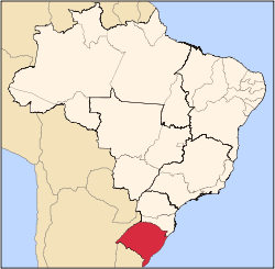
 São Borja Location in Brazil | |||
| Coordinates: 28°39′36.84″S 56°00′13.82″W / 28.6602333°S 56.0038389°WCoordinates: 28°39′36.84″S 56°00′13.82″W / 28.6602333°S 56.0038389°W | |||
| Country | Brazil | ||
| Region | South | ||
| State | State of Rio Grande do Sul | ||
| Founded | March 11, 1833 | ||
| Area | |||
| • Total | 3,640 km2 (1,410 sq mi) | ||
| Elevation | 123 m (404 ft) | ||
| Population (2014)[1] | |||
| • Total | 61.671 | ||
| • Density | 2,795/km2 (7,240/sq mi) | ||
| Time zone | UTC-3 (UTC-3) | ||
| • Summer (DST) | UTC-2 (UTC-2) | ||
| Website | http://www.saoborja.rs.gov.br | ||


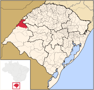
Location in Rio Grande do Sul State
São Borja is a city in the Brazilian state of Rio Grande do Sul. São Borja is the oldest municipality in the Brazilian state of Rio Grande do Sul and was founded in 1682 by the Jesuits as the first of the Seven Points of the Missions, and named São Francisco de Borja, in honor of Saint Francis Borgia. It is situated on the Western Frontier of Rio Grande do Sul on the border with Argentina which is defined by the Uruguai river.
São Borja is known as the Land of the Presidents as it is the birthplace of two Brazilian Presidents: Getúlio Vargas (1882–1954) and João Goulart (1919–1976).
The city is linked to the Argentinian city of Santo Tomé through the Integration Bridge.
The city is served by São Borja Airport.
References
This article is issued from Wikipedia - version of the 5/16/2016. The text is available under the Creative Commons Attribution/Share Alike but additional terms may apply for the media files.