Ruth Glacier
| Ruth Glacier | |
|---|---|
|
Ruth Glacier | |
| Type | Valley glacier |
| Location | Matanuska-Susitna Borough, Alaska, U.S. |
| Coordinates | 62°45′55″N 150°37′42″W / 62.76528°N 150.62833°WCoordinates: 62°45′55″N 150°37′42″W / 62.76528°N 150.62833°W |
| Length | 40 miles (64 km) |
| Thickness | 3,800 feet (1,200 m) (1983) |
| Terminus | moraine |
| Status | unknown |
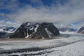
Ruth Glacier is a glacier in Denali National Park and Preserve in the U.S. state of Alaska.[1] Its upper reaches are almost three vertical miles (4.8 km) below the summit of Denali. The glacier's "Great Gorge" is one mile (1.6 km) wide, and drops almost 2,000 feet (610 m) over ten miles (16 km), with crevasses along the surface. Above the surface on both sides are 5,000-foot (1,500-m) granite cliffs. From the top of the cliffs to the bottom of the glacier is a height exceeding that of the Grand Canyon. Ruth Glacier moves at a rate of 3.3 feet (1 m) a day and was measured to be 3,800 feet (1,200 m) thick in 1983.[2]
Surrounding the Ruth Gorge are many mountains of the Alaska Range, including the Mooses Tooth, with highly technical ice and rock climbs on their faces.
See also
Cited references
- ↑ "USGS Talkeetna D-2 (AK) Topo Map". Topozone. Retrieved 2007-01-25.
- ↑ "Ruth Glacier". Denali National Park and Preserve. National Park Service. Retrieved 2007-01-25.
| Wikimedia Commons has media related to Ruth Glacier. |