Russell Glacier (Mount Rainier)
| Russell Glacier | |
|---|---|
|
Ablation zone of Russell Glacier with Carbon Glacier behind | |
| Type | Mountain glacier |
| Location | Mount Rainier, Pierce County, Washington, USA |
| Coordinates | 46°53′52″N 121°47′20″W / 46.89778°N 121.78889°W |
| Area | 1.3 square miles (3.4 km2), 1983[1] |
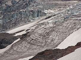
The Russell Glacier is a medium-sized glacier on the north flank of Mount Rainier, Washington. Named for the geologist Israel Russell,[2] it covers 1.3 square miles (3.4 km2) and contains 3.1 billion ft3 (88 million m3) of ice.[1] Starting from its highest point at 9,400 feet (2,900 m), the Russell Glacier flows northeast towards the Carbon Glacier and contributes ice to the larger glacier before becoming distinct below 7,000 feet (2,100 m).[3] With most of the ice located from 8,000 feet (2,400 m) to 9,000 feet (2,700 m), the glacier only descends to 6,800 feet (2,100 m), unlike the much lower extent of the Carbon Glacier.[3] Echo Rock and 8,364 ft (2,549 m) Observation Rock, two minor sub-peaks of Rainier, lie northwest of this glacier. Meltwater from the glacier eventually reaches the Carbon River.[1]
See also
References
- 1 2 3 "DESCRIPTION: Mount Rainier Glaciers and Glaciations - Mount Rainier Glacier Hazards and Glacial Outburst Floods". USGS. Retrieved 2007-11-19.
- ↑ Majors, Harry M. (1975). Exploring Washington. Van Winkle Publishing Co. p. 125. ISBN 978-0-918664-00-6.
- 1 2 "USGS Mowich Lake (WA) Topo Map". USGS Quad maps. TopoQuest.com. Retrieved 2008-05-17.