Rural City of Benalla
| Rural City of Benalla Victoria | |||||||||||||
|---|---|---|---|---|---|---|---|---|---|---|---|---|---|
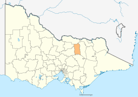 Location in Victoria | |||||||||||||
| Population | 13,496 (2015 est)[1] | ||||||||||||
| • Density | 5.6825/km2 (14.718/sq mi) | ||||||||||||
| Established | 2002 | ||||||||||||
| Gazetted | 17 October 2002[2] | ||||||||||||
| Area | 2,375 km2 (917.0 sq mi) | ||||||||||||
| Mayor | Cr Barbara Alexander | ||||||||||||
| Council seat | Benalla | ||||||||||||
| Region | Hume | ||||||||||||
| State electorate(s) | Euroa | ||||||||||||
| Federal Division(s) | Indi | ||||||||||||
|
| |||||||||||||
| Website | Rural City of Benalla | ||||||||||||
| |||||||||||||
The Rural City of Benalla is a local government area in the Hume region of Victoria, Australia, located in the north-east part of the state. It covers an area of 3,843 square kilometres (1,484 sq mi) and, at the 2011 Census, had a population of 7,893.[3] It includes the towns of Baddaginnie, Benalla, Devenish, Goorambat, Major Plains, Swanpool, Tatong, Thoona, Warrenbayne and Winton. It was formed in 2002 from the de-amalgamation of the Shire of Delatite into the current rural city and the Shire of Mansfield.[2]
The Rural City is governed and administered by the Benalla Rural City Council; its seat of local government and administrative centre is located at the council headquarters in Benalla. The Rural City is named after the main urban settlement located in the centre-north of the LGA, that is Benalla, which is also the LGA's most populous urban centre with a population of 10,331.[4]
Council
Current composition
The council is composed of seven councillors elected to represent an unsubdivided municipality.[5]
| Ward | Councillor | Notes | |
|---|---|---|---|
| Unsubdivided | Barbara Alexander | Mayor (2013–14) | |
| Peter Davis | |||
| Ellen Crocker | |||
| Andrew Vale | |||
| Justin King | |||
| Suzy Martin | |||
| Margaret Richards | |||
Administration and governance
The council meets in the council chambers at the council headquarters in the Benalla Municipal Offices, which is also the location of the council's administrative activities. It also provides customer services at its administrative centre in Benalla.
See also
References
- ↑ "3218.0 – Regional Population Growth, Australia, 2014–15". Australian Bureau of Statistics. Retrieved 29 September 2016.
- 1 2 Victoria Government Gazette – Online Search (1998–present). "G42 of 2002" (PDF). Victoria Government Gazette. State Government of Victoria (published 17 October 2002). pp. 85–97. Retrieved 10 January 2014. Check date values in:
|date=(help);|article=ignored (help) - ↑ Census QuickStats (2011). "Benalla (RC) – LGA21010". Australian Bureau of Statistics. Government of Australia. Retrieved 10 January 2014.
- ↑ Census QuickStats (2011). "Benalla (SS) – SSC20115". Australian Bureau of Statistics. Government of Australia. Retrieved 10 January 2014.
- ↑ Local Government in Victoria. "Benalla Rural City Council". Department of Transport, Planning and Local Infrastructure. State Government of Victoria. Retrieved 10 January 2014.
External links
- Benalla Rural City Council official website
- Metlink local public transport map
- Link to Land Victoria interactive maps
Coordinates: 36°33′00″S 145°58′00″E / 36.55000°S 145.96667°E