Ruptawa


Ruptawa (German: Ruptau) is a sołectwo in the south of Jastrzębie-Zdrój, Silesian Voivodeship, southern Poland. It was an independent village but became administratively part of Jastrzębie-Zdrój in 1975.[1]
It has na area of 1522,51 ha and on December 31, 2012 it had 3,741 inhabitants.[2]
History
The village was first mentioned in a Latin document of Diocese of Wrocław called Liber fundationis episcopatus Vratislaviensis from around 1305 as item in Ruptava debent esse triginta mansi.[3][4] The creation of the village was a part of a larger settlement campaign taking place in the late 13th century on the territory of what would later be known as Upper Silesia. A Catholic parish was also established in the process. Politically the village belonged then to the Duchy of Racibórz, within feudally fragmented Poland. In 1327 the duchy became a fee of the Kingdom of Bohemia, which after 1526 became part of the Habsburg Monarchy. After Silesian Wars it became a part of the Kingdom of Prussia. In 1908 the village became a seat of a Lutheran parish.
In the interwar period it was one of only several municipalities in the Upper Silesian (thus excluding Cieszyn Silesia) part of autonomous Silesian Voivodeship which had over 10% of the Protestant population (29.7% in 1933).[5] It was later annexed by Nazi Germany at the beginning of World War II, and returned to Poland afterwards.
-
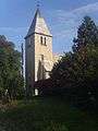
Old Lutheran church
-

New Lutheran church
References
- ↑ Rozporządzenie Rady Ministrów z dnia 22 maja 1975 r. w sprawie zmiany granic niektórych miast w województwie katowickim, Dz. U. z 1975 r. Nr 15, poz. 88
- ↑ "Sołectwo Ruptawa". www.jastrzebie.pl. Retrieved 2015-05-04.
- ↑ Schulte, Wilhelm (1889). Codex Diplomaticus Silesiae T.14 Liber Fundationis Episcopatus Vratislaviensis (in German). Breslau.
- ↑ "Liber fundationis episcopatus Vratislaviensis" (in Latin). Retrieved 13 July 2014.
- ↑ Czembor, Henryk (1993). Ewangelicki Kościół Unijny na polskim Górnym Śląsku (in Polish). Katowice: Dom Wydawniczy i Księgarski "Didache". p. 45. OCLC 80237547.
Coordinates: 49°55′22″N 18°36′05″E / 49.922716°N 18.601444°E