Ruoms
| Ruoms | ||
|---|---|---|
|
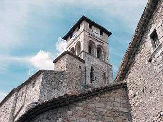
Church Saint-Pierre-aux-liens of Ruoms | ||
| ||
 Ruoms | ||
|
Location within Auvergne-Rhône-Alpes region  Ruoms | ||
| Coordinates: 44°27′14″N 4°20′34″E / 44.4539°N 4.3428°ECoordinates: 44°27′14″N 4°20′34″E / 44.4539°N 4.3428°E | ||
| Country | France | |
| Region | Auvergne-Rhône-Alpes | |
| Department | Ardèche | |
| Arrondissement | Largentière | |
| Canton | Vallon-Pont-d'Arc | |
| Government | ||
| • Mayor (2008–2014) | Daniel Serre | |
| Area1 | 12.14 km2 (4.69 sq mi) | |
| Population (2008)2 | 2,245 | |
| • Density | 180/km2 (480/sq mi) | |
| Time zone | CET (UTC+1) | |
| • Summer (DST) | CEST (UTC+2) | |
| INSEE/Postal code | 07201 / 07120 | |
| Elevation |
80–252 m (262–827 ft) (avg. 120 m or 390 ft) | |
|
1 French Land Register data, which excludes lakes, ponds, glaciers > 1 km² (0.386 sq mi or 247 acres) and river estuaries. 2 Population without double counting: residents of multiple communes (e.g., students and military personnel) only counted once. | ||
.svg.png)
Ruoms is a commune in the Ardèche department in southern France.
Population
| Historical population | ||
|---|---|---|
| Year | Pop. | ±% |
| 1793 | 629 | — |
| 1800 | 575 | −8.6% |
| 1806 | 717 | +24.7% |
| 1821 | 711 | −0.8% |
| 1831 | 839 | +18.0% |
| 1836 | 880 | +4.9% |
| 1841 | 880 | +0.0% |
| 1846 | 964 | +9.5% |
| 1851 | 986 | +2.3% |
| 1856 | 1,044 | +5.9% |
| 1861 | 1,022 | −2.1% |
| 1866 | 1,104 | +8.0% |
| 1872 | 1,122 | +1.6% |
| 1876 | 1,222 | +8.9% |
| 1881 | 1,565 | +28.1% |
| 1886 | 1,713 | +9.5% |
| 1891 | 1,666 | −2.7% |
| 1896 | 1,791 | +7.5% |
| 1901 | 1,788 | −0.2% |
| 1906 | 1,833 | +2.5% |
| 1911 | 1,789 | −2.4% |
| 1921 | 1,468 | −17.9% |
| 1926 | 1,444 | −1.6% |
| 1931 | 1,508 | +4.4% |
| 1936 | 1,423 | −5.6% |
| 1946 | 1,271 | −10.7% |
| 1954 | 1,341 | +5.5% |
| 1962 | 1,474 | +9.9% |
| 1968 | 1,620 | +9.9% |
| 1975 | 1,700 | +4.9% |
| 1982 | 1,794 | +5.5% |
| 1990 | 1,858 | +3.6% |
| 1999 | 2,132 | +14.7% |
| 2008 | 2,245 | +5.3% |
See also
References
| Wikimedia Commons has media related to Ruoms. |
This article is issued from Wikipedia - version of the 10/28/2016. The text is available under the Creative Commons Attribution/Share Alike but additional terms may apply for the media files.