Runde Bridge
| Runde Bridge Rundebrua | |
|---|---|
|
View of Rundebrua (looking south) | |
| Coordinates | 62°22′45″N 05°37′39″E / 62.37917°N 5.62750°ECoordinates: 62°22′45″N 05°37′39″E / 62.37917°N 5.62750°E |
| Carries | Fylkesvei 18 |
| Crosses | Rundesundet |
| Locale | Herøy |
| Characteristics | |
| Design | Cantilever bridge |
| Total length | 428 m (1,404 ft) |
| History | |
| Opened | 3 March 1982 |
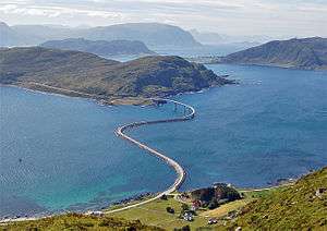
Runde Bridge (Norwegian: Rundebrua) is a cantilever bridge that crosses the Rundasundet between the islands Remøya and Runde in the municipality of Herøy in Møre og Romsdal county, Norway. [1][2]
.jpg)
Rundebrua
Runde Bridge is located about 5 kilometres (3.1 mi) north of Fosnavåg and about 12 kilometres (7.5 mi) northwest of Ulsteinvik.[3] The 428-metre (1,404 ft) long bridge carries the Fyklesvei 18 highway. Runde Bridge opened on 3 March 1982.
See also
- Herøy Bridge
- Remøy Bridge
- Nerlandsøy Bridge
- List of bridges in Norway
- List of bridges in Norway by length
- List of bridges
- List of bridges by length
References
External links
- Road Viaducts & Bridges in Norway (499-200 m)
- http://fuv.hivolda.no/prosjekt/haraldeikrem/Rundebrua.jpg
- http://www.etojm.com/Galleri/Galleri21_30/G29Runde/Rundebrua.htm
- http://www.runde.nl/content/foto_htm/b13.htm
This article is issued from Wikipedia - version of the 12/1/2016. The text is available under the Creative Commons Attribution/Share Alike but additional terms may apply for the media files.