Rue du Bac, Paris
|
Rue du Bac | |
 | |
| Length | 1,150 m (3,770 ft) |
|---|---|
| Width | 20 m (66 ft) (average) between quais Anatole France and Voltaire and the boulevard Saint-Germain. 18 m between the Boulevard Saint-Germain and the rue de Sèvres |
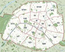
| Arrondissement | 7th |
| Quarter | Saint-Thomas d'Aquin |
| From | quai Voltaire, Paris and quai Anatole France |
| To | rue de Sèvres, Paris |
| Construction | |
| Completion | Opened between 1600 à 1610 |

Rue du Bac is a street in Paris situated in the 7th arrondissement. The street, which is 1150 m long, begins at the junction of the quais Voltaire and Anatole-France and ends at the rue de Sèvres.
Rue du Bac is also the name of a station on line 12 of the Paris Métro, although its entrance is actually located on the boulevard Raspail at the point where it is joined by the rue du Bac.
History
Rue du Bac owes its name to a ferry (bac) established toward 1550 on what is now the quai Voltaire, to transport stone blocks for the construction of the Palais des Tuileries. It crossed the Seine at the site of today's Pont Royal, bridge constructed under the reign of Louis XIV to replace the pont rouge built in 1632 by the financier Barbier.
Originally, the street was named grand chemin du Bac, then ruelle du Bac and grande rue du Bac.
Buildings of note
Odd numbers
- n° 1 : Building by Auguste Rolin and C. La Horgue in 1882-1883.
- n°s 83-85 : Former monastery of the Immaculate Conception built in 1637. It also occupied numbers 87 and 89 rue de Grenelle onto which the garden extended.
- n° 97 : Hôtel de Ségur (also called de Salm-Dyck) : This house was built in 1722 for Pierre Henry Lemaître (also owner of the château du Marais), perhaps for François Debias-Aubry. Some of the interior décor dates to this period. From 1786 to 1792 and from 1796 to 1798 it was occupied by Madame de Staël, who held a regular salon here.
- n° 101 : Hôtel de La Feuillade.
Even numbers
- n°s 2-4 : The Caisse des dépôts et consignations, the public financial institution created in 1816 to control financial affairs in the public's interest. (See also: Quai Anatole-France).
- n° 40 : The door of this building opens on a perpendicular passage to the rue du Bac. Inside the passage was the Hôtel Cochin where lived Charles de Montalembert (publicist, historian, politician).
- n° 44 : In 1932, André Malraux composed a portion of "Man's Fate", or La Condition humaine (plaque).
- n° 46 : Outside door has panels representing Prudence and Law sculpted by Michel Varin. The original 18th century interior had sumptuous wood paneling adorned with work by the painters Carle Van Loo, Jean-Baptiste Oudry, Jean II Restout. It was dispersed at the end of the 19th century. Some of its elements have been redisplayed at the musée Jacquemart-André, the Hôtel de Pontalba (rue du Faubourg-Saint-Honoré) and the castle of Vaux-le-Pénil (near Melun in Seine-et-Marne department).
- n° 70 : Building from the years 1830-1840.
- n° 102 : Hôtel de Sainte-Aldegonde, built in the first half of the 18th century.
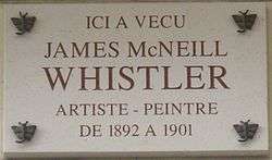
- n° 110 : Across courtyard, studio and house constructed in 1812 for himself by Pierre-Louis Baltard, father of the architect Victor Baltard. The ground floor of the house was occupied by James McNeill Whistler from 1892 to 1901.[1]
- n°s 118-120 : Two hotels, separated by a "party wall", built between 1713–1715 by Claude Nicolas Lepas-Dubuisson for the Missions étrangères de Paris. The hotel at n° 120 is known as the hôtel de Clermont-Tonnerre, name of the landlord who held the property at the end of the 18th century, and where François-René de Chateaubriand lived in 1838 and died in 1848. The doors representing the four corners of the world (the evangelical goal of the Missions étrangères de Paris) are of exceptional quality: probably the work of Jean-Baptiste Tureau.
- n° 128 : Missions étrangères de Paris, an evangelical Catholic organization : The chapel was built between 1683 et 1689 by master mason Lepas-Dubuisson (father of the architect of n°s 118-120).
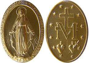
- n°s 136-140 : Older buildings constituting the convent Maison des Filles de la Charité de Saint-Vincent-de-Paul (mother house of the Daughters of Charity of Saint Vincent de Paul), including the Chapel of Our Lady of the Miraculous Medal, notable as the final resting place of St. Catherine Labouré, who was at the origin of the creation of the Miraculous Medal 48°51′04″N 2°19′26″E / 48.850974°N 2.323770°E. This is the address where the character Mr Klein lived in the film Mr Klein (http://www.imdb.com/title/tt0074916/) (1976).
Destroyed buildings
- n° 84 : Former entrance into the garden of the Hôtel de Galliffet which has its main entrance at 73 rue de Grenelle. Marked by a massive porch that was torn down in 1837.
- n° 86 : Site of the former Hôtel Dillon.
References
- ↑ Ronald Anderson and Anne Koval, James McNeill Whistler: Beyond the Myth, Carroll & Graf, New York, 1994, pg. 357 et seq.
(French) This article was drawn mainly from the French Wikipedia article.
Further reading
- Charles Loyson
- Daughters of Charity of Saint Vincent de Paul
External links
| Wikimedia Commons has media related to Rue du Bac. |
- (French) Official nomenclature of Parisian streets
- (French) Insecula
- (French) www.paris-pittoresque.com
Bibliography
- Bruno Pons et Anne Forray-Carlier (dir.), La Rue du Bac, Paris, Délégation à l'action artistique de la Ville de Paris, 1991 – ISBN 2-905118-33-4
Coordinates: 48°51′23″N 2°19′35″E / 48.85639°N 2.32639°E