Rue de Provence
Coordinates: 48°52′27.02″N 2°20′10.57″E / 48.8741722°N 2.3362694°E
 | |
 | |
| Length | 1,193 m (3,914 ft) |
|---|---|
| Width | 18 m (59 ft) |
| Arrondissement | 8th, 9th |
| Quarter | Chaussée d'Antin. Madeleine |
| From | Rue du Faubourg-Montmartre |
| To | Rue de Rome |
| Construction | |
| Completion | 1771 |
| Located near the Métro stations: Le Peletier, Havre - Caumartin and Trinité - d'Estienne d'Orves. |

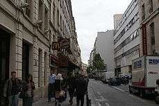
and its arch-shaped entrance (1778)
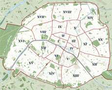
The rue de Provence is mainly in the 9th arrondissement of Paris. Only the short part of the street between rue du Havre and rue de Rome is in the 8th arrondissement.
At this place was a little river called "ruisseau de Menilmontant" (Menilmontant brook). With the Parisian population increasing, this little river became the Grand Egout (great sewer) with a two-metre width in the 17th century. Letters patent of 15 December 1770 allowed the banker Jean-Joseph de Laborde to create a 30-foot wide street by covering the "Grand Egout".
"Provence" is the name of a region in the south-east of France, but the name of the street is in honour of Louis-Stanislas-Xavier, comte de Provence, king of France from 1814 to 1824 under the name of Louis XVIII.

Notable places
- n° 22 (corner of rue Chauchat): 18th-century mansion transformed by Samuel Bing into an Art Nouveau exposition building in 1895. Sold in 1904 to the ébénist Louis Majorelle as an exposition room. Now a post office, keeping the exterior decoration.
- n° 32: Rare example of a building built in the late 1790s.[1]
- n° 34: The door is the only remainder of the hôtel Thellusson built in 1778 by Claude-Nicolas Ledoux for the widow of Swiss banker Georges-Tobie de Thellusson.[1] The opening of the hôtel on the rue de Provence was a huge triumphal arch. The hôtel was destroyed in 1826 when the rue Laffitte was lengthened.
- n° 122: location of one of the most famous former lupanars, the One-two-two.
- n° 126: Building built in 1911 by Henri Sauvage and Charles Sarrazin for the French decorator Louis Majorelle.[1]
Notes
References
| Wikimedia Commons has media related to Rue de Provence (Paris). |
- (French) Félix Lazare, Dictionnaire administratif et historique des rues de Paris et de ses monuments, Paris, Imprimerie de Vinchon, 1844–1849
- (French) Histoire de Paris rue par rue, maison par maison, Charles Lefeuve, 1875 (http://www.paris-pittoresque.com/rues/234.htm)
- (French) Jean-Marie Pérouse de Montclos (dir.), Le Guide du Patrimoine. Paris, Paris, Hachette, 1994
- (French) Félix de Rochegude, Promenades dans toutes les rues de Paris. VIIIe arrondissement, Paris, Hachette, 1910
- (French) Rue de Provence on the web site wikiparis