Ruborough Camp
| Ruborough Camp | |
|---|---|
|
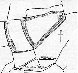
Plan of earthworks at Ruborough Camp | |
| Location | Broomfield, Somerset, England |
| Coordinates | 51°05′46″N 3°06′18″W / 51.09611°N 3.10500°WCoordinates: 51°05′46″N 3°06′18″W / 51.09611°N 3.10500°W |
| Area | 1.8 hectares (4.4 acres) |
| Built | Iron Age |
| Reference no. | 191142[1] |
 Location of Ruborough Camp in Somerset | |
Ruborough Camp is an Iron Age hill fort on the Quantock Hills near Broomfield in Somerset, England. The name comes from Rugan beorh or Ruwan-beorge meaning Rough Hill. It is a Scheduled Ancient Monument[2] and on the Heritage at Risk register.[3]
Background
Hill forts developed in the Late Bronze and Early Iron Age, roughly the start of the first millennium BC.[4] The reason for their emergence in Britain, and their purpose, has been a subject of debate. It has been argued that they could have been military sites constructed in response to invasion from continental Europe, sites built by invaders, or a military reaction to social tensions caused by an increasing population and consequent pressure on agriculture. The dominant view since the 1960s has been that the increasing use of iron led to social changes in Britain. Deposits of iron ore were located in different places to the tin and copper ore necessary to make bronze, and as a result trading patterns shifted and the old elites lost their economic and social status. Power passed into the hands of a new group of people.[5] Archaeologist Barry Cunliffe believes that population increase still played a role and has stated "[the forts] provided defensive possibilities for the community at those times when the stress [of an increasing population] burst out into open warfare. But I wouldn't see them as having been built because there was a state of war. They would be functional as defensive strongholds when there were tensions and undoubtedly some of them were attacked and destroyed, but this was not the only, or even the most significant, factor in their construction".[6]
Description
The hill fort is on an easterly spur from the main Quantock ridge, with steep natural slopes to the north and south-east. The fort is triangular in shape, with a single rampart and ditch (univallate), enclosing 1.8 hectares (4.4 acres). There is a linear outer work about 120 m away, parallel to the westerly rampart, enclosing another 1.8 ha.
There was a subterranean tunnel, which has now been filed in, which gave the camp safe access to a nearby spring for water.[7]
It was common for ancient hill forts to be reused as pens for domesticated animals in the Medieval period, and there is documentary evidence that Ruborough became a porcheria, or piggery, owned by the Saxon domain of Somerton.
See also
References
- Dumnonia and the Valley of the Parret, Rev W.H.P.Greswell, 1922
- ↑ "Ruborough Camp". National Monuments Record. English Heritage. Retrieved 26 March 2011.
- ↑ "Ruborough Camp Hillfort.". Digital Digging. Retrieved 27 August 2010.
- ↑ "Ruborough Camp large univallate hillfort, Broomfield – Sedgemoor". Heritage at Risk. English Heritage. Retrieved 14 October 2013.
- ↑ Payne, Andrew; Corney, Mark; Cunliffe, Barry (2007), The Wessex Hillforts Project: Extensive Survey of Hillfort Interiors in Central Southern England, English Heritage, p. 1, ISBN 978-1-873592-85-4
- ↑ Sharples, Niall M (1991), English Heritage Book of Maiden Castle, London: B. T. Batsford, pp. 71–72, ISBN 0-7134-6083-0
- ↑ Time Team: Swords, skulls and strongholds, Channel 4, 2008-05-19, retrieved 16 September 2009
- ↑ Waite, Vincent (1964). Portrait of the Quantocks. London: Robert Hale. ISBN 0-7091-1158-4.