Rozsochatec
| Rozsochatec | |||
|---|---|---|---|
| Municipality | |||
 | |||
| |||
 Rozsochatec | |||
| Coordinates: 49°40′50″N 15°37′59″E / 49.68056°N 15.63306°ECoordinates: 49°40′50″N 15°37′59″E / 49.68056°N 15.63306°E | |||
| Country |
| ||
| Region | Vysočina | ||
| District | Havlíčkův Brod | ||
| Area | |||
| • Total | 9.23 km2 (3.56 sq mi) | ||
| Elevation | 480 m (1,570 ft) | ||
| Population (2006) | |||
| • Total | 519 | ||
| • Density | 56/km2 (150/sq mi) | ||
| Postal code | 580 01 to 582 72 | ||
| Website | http://www.rozsochatec.cz/ | ||

Rozsochatec is a village and municipality (obec) in Havlíčkův Brod District in the Vysočina Region of the Czech Republic.
The municipality covers an area of 9.23 square kilometres (3.56 sq mi), and has a population of 519 (as at 28 August 2006).
Rozsochatec lies approximately 10 kilometres (6 mi) north-east of Havlíčkův Brod, 32 km (20 mi) north of Jihlava, and 98 km (61 mi) south-east of Prague.
Gallery
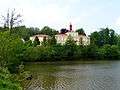 Rozsochatec Castle
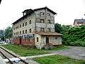 Train station
References
| Wikimedia Commons has media related to Rozsochatec. |
This article is issued from Wikipedia - version of the 4/7/2016. The text is available under the Creative Commons Attribution/Share Alike but additional terms may apply for the media files.