Royal Botanical Gardens (Ontario)
|
| |
 | |
| Abbreviation | RBG |
|---|---|
| Type | Organizations based in Canada with royal patronage |
| Legal status | active |
| Purpose | advocate and public voice, educator and network |
| Headquarters | Burlington, Ontario, Canada |
Region served | Burlington and Hamilton, Ontario, Canada |
Official language | English, French |
Royal Botanical Gardens (RBG) is headquartered in Burlington and also owns extensive natural areas and gardens lands in Hamilton, Ontario, Canada. It is one of the major tourist attractions between Niagara Falls and Toronto, as well as a significant local and regional horticultural, education, conservation, and scientific resource. On 31 July 2006, Royal Botanical Gardens was selected as the National Focal Point for the Global strategy for plant conservation (GSPC) by Environment Canada.[1]
The 980 hectares (2,422 acres) of nature sanctuary owned by the Royal Botanical Gardens is considered an important plant biodiversity hotspot for Canada, with a very high proportion of the wild plants of Canada in one area; is an Important Bird Area according to Bird Studies Canada;,[2] and is part of the Niagara Escarpment World Biosphere Reserve.[3] More than 1,100 species of plants grow within its boundaries including the Bashful Bulrush (Trichophorum planifolium) which is found nowhere else in Canada, and the largest remaining population of Canada's most endangered tree, the Red Mulberry (Morus rubra). Both of these plants are listed as Endangered in Canada under the Species at Risk Act.[4][5] In 2008, the RBG was designated as an Important Amphibian and Reptile Area by CARCNET, the Canadian Amphibian and Reptile Conservation Network.
History
Royal Botanical Gardens developed as a concept in the 1920s under the City of Hamilton Board of Park Management, led by Thomas McQuesten. Initially the proposed botanical garden was to be located along the south shore of Cootes Paradise Marsh surrounding the Hamilton campus of McMaster University. The proposed botanical garden would also protect extensive natural areas along the marsh.[6]
Formal permission was obtained in 1930 from King George V to call the gardens the "Royal Botanical Gardens".[7] At the same time as the proposal for the botanical gardens was under consideration, the City of Hamilton was undertaking an ambitious program of beautification on the nearby Burlington Heights. The North-Western Entrance to Hamilton project included an extensive set of gardens designed by the Toronto firm of Wilson, Bunnell and Borgstrom. Among these was the Rock Garden created by lining a 5.5 acre abandoned gravel pit with limestone from the Niagara Escarpment. In 1932 the Board of Park Management brought together the Burlington Heights gardens and the south shore of Cootes Paradise as Royal Botanical Gardens.
The original vision of RBG was a mixture of horticultural displays and protected natural forests and wetlands. The first Director of RBG, Dr. Norman Radforth, was appointed in 1947 and was a Professor of Botany at nearby McMaster University. In 1954 Leslie Laking, initially Assistant Director and Horticulturist, was appointed as Director and served until 1981. Under his guidance, the institution developed into the major entity it is today. With approximately 1,100 ha (2,700 acres) of property, Royal Botanical Gardens is one of the largest such institutions in North America. In 2006, the Auxiliary of RBG published Love, sweat and soil: a history of Royal Botanical Gardens from 1930 to 1981 authored by Dr. Laking.[8]
Financial
Funding for the institution was initially provided largely by the City of Hamilton and then in the 1940s by the Province of Ontario. By the early 1980s, funding restrictions and the desire to become increasingly self-supported led to charging of an admission fee for the cultivated garden areas. Admission is free to members. The extensive system of nature trails, more than 20 kilometres (12 mi) in length, has remained accessible free of charge. As of 2006, approximately 40% of the RBG's annual budget comes from support from the Province of Ontario, the City of Hamilton and the Region of Halton. The remainder, 60%, is classed as 'self-generated revenue' and is raised annually from admissions, memberships, donations, summer camps, and fees-for-service.
An organized volunteer group of more than 300 members called the RBG Auxiliary supports the efforts of the RBG. Annually, the Auxiliary raises tens of thousands of dollars and donates tens of thousands of hours in such roles as tour guides, staffing the RBG Library and RBG Archives, and some gardening[9]
Attractions
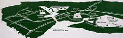
Royal Botanical Gardens presents five garden areas to visitors: Hendrie Park, RBG Centre (which includes the Mediterranean Garden, RBG's only conservatory), The Arboretum, Laking Garden, and the David Braley and Nancy Gordon Rock Garden. Major natural areas include trails through the valley of the lower Grindstone Creek, Rock Chapel, north and south shores of Cootes Paradise, and Princess Point.
Long standing RBG trails on the Niagara Escarpment at Rock Chapel are part of the original founding of the Bruce trail. In 2010, RBG partnered with Geotrail to bring their trail network to the internet through an interactive website.[10]
The natural lands or nature sanctuaries of Royal Botanical Gardens include some of the most significant wildlife and native plant areas in Canada. The largest area, which includes the wetland called Cootes Paradise or Dundas Marsh, is a major spawning area for native fish species in Lake Ontario, one of the best bird-watching areas in Canada,[2] and is the subject of one of Canada's largest ecological rehabilitation efforts aimed at a wetland, 'Project Paradise.'
Royal Botanical Gardens holds the second-largest garden show in Canada simply called The Ontario Garden Show. It comes second only to Canada Blooms which is held in Toronto.
Innovative educational programs are operated from both RBG's main building in Burlington and the Nature Interpretive Centre, located in the Arboretum to the north of Cootes Paradise in Hamilton. Over 18,000 school children per year visit the organized school programs, and over 200 public education offerings include such diverse topics as botanical illustration, organic cooking and basic botany. Aldershot School offers an ECO Studies program in conjunction with the RBG.[11]
Royal Botanical Gardens is a member of the American Public Gardens Association and Botanic Gardens Conservation International and is very active in local, regional, national, and international efforts to conserve plant diversity and ensure its sustainable use.
The Gardens span Bayview Junction, hosting several popular locations for railfanning.
Images
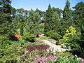 Rock Gardens, RBG
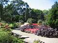 Rock Gardens, RBG
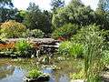 Rock Gardens, RBG
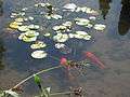 Rock Gardens, RBG
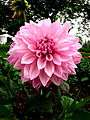 Dahlia, 2008 Rose Celebration, RBG
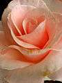 Rose Celebration, RBG
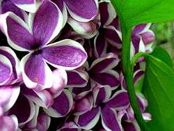 Blooms at the Lilac Celebration, RBG
See also
| Wikimedia Commons has media related to Royal Botanical Gardens (Ontario). |
- List of attractions in Hamilton, Ontario
- List of Canadian organizations with royal patronage
- List of UNESCO Biosphere Reserves in Canada
- Green Fleet Expo
- Toronto Botanical Garden
References
- ↑ "Botanical Garden named National Focal Point for Plant Conservation". Botanic Gardens Conservation International. 2006-08-02. Retrieved 2009-05-04.
- 1 2 "Dundas Valley and Dundas Marsh - Dundas, Ontario". Bird Studies Canada. Retrieved 2009-05-03.
- ↑ "Biosphere Reserve Information - Canada - Niagara Escarpment Biosphere Reserve". MAB Biosphere Reserves Directory. UNESCO. Retrieved 2009-05-03.
- ↑ "Species Profile - Bashful Bulrush". Species at Risk Public Registry. Environment Canada. 2008-04-25.
- ↑ "Species Profile - Red Mulberry". Species at Risk Public Registry. Environment Canada. 2008-04-25.
- ↑ Riley, John L. (2013-10-01). The Once and Future Great Lakes Country: An Ecological History. MQUP. p. 274. ISBN 978-0-7735-8982-7. Retrieved 2014-07-07.
- ↑ "Gardens' History". Royal Botanical Gardens. Archived from the original on April 2, 2009. Retrieved 2009-05-04.
- ↑ Laking, Leslie (2006). Love, sweat and soil: a history of Royal Botanical Gardens from 1930 to 1981. Hamilton, ON: Royal Botanical Gardens Auxiliary. ISBN 978-0-9691759-4-0. OCLC 64344711.
- ↑ "RBG Auxiliary Volunteer Opportunities and Information Page". The Royal Botanical Gardens. Retrieved 2015-06-14.
- ↑ InsideHalton Article: RBG hikers, bird watchers benefit from trail software
- ↑ "RBG ECO Studies". Aldershot School. Retrieved 2009-05-03.
- "Annual report to the community" (PDF). Royal Botanical Gardens. 2007. Archived from the original (PDF) on July 8, 2009. Retrieved 2009-05-03.
External links
Coordinates: 43°17′28″N 79°52′33″W / 43.29111°N 79.87583°W