Massachusetts Route 106
| ||||
|---|---|---|---|---|
|
Map of southeastern Massachusetts with Route 106 highlighted in red | ||||
| Route information | ||||
| Maintained by MassDOT | ||||
| Length: | 34.31 mi[1] (55.22 km) | |||
| Major junctions | ||||
| West end: |
| |||
| ||||
| East end: |
| |||
| Location | ||||
| Counties: | Norfolk, Bristol, Plymouth | |||
| Highway system | ||||
| ||||

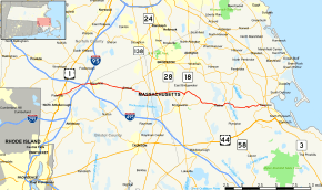
Route 106 is a west–east highway in southeastern Massachusetts, United States.
Route description
Route 106 begins in Plainville at Route 1A. The route heads east, intersecting U.S. Route 1 and Route 152 in quick succession, with Turnpike Lake between the three routes. As Route 106 passes south of Lake Mirimichi it enters the town of Foxborough. In Foxborough, Route 106 passes over I-495 and under I-95 within three quarters of a mile without access to either interstate. The road crosses into Mansfield in Bristol County, where it intersects Route 140 between the two interstates.

Route 106 continues eastward through the town, passing south of the Mansfield MBTA Station (on the Providence/Stoughton Line of the MBTA Commuter Rail). It then enters Easton, where it becomes concurrent with Route 123 for a mile, crossing Bay Road at the Five Corners, where the two routes split. It then crosses Route 138 before entering West Bridgewater in Plymouth County.
In West Bridgewater, Route 106 crosses Route 24 at Exits 16 A-B. Near the center of town it crosses Route 28. It crosses the Middleborough/Lakeville Line as it enters East Bridgewater. In East Bridgewater, Route 106 shares a short, quarter-mile concurrency with Route 18 in the village of Elmwood. It continues eastward, following the Bridgewater town line as intersects the eastern end of Route 104. The route enters Halifax, passing through swampland as it intersects the northern end of Route 105. It passes through the center of town before intersecting with Route 58 south of the Monponsett Ponds. Near the southeast corner of East Monponsett Pond, Route 106 meets the southern end of Route 36.
Route 106 continues eastward, passing through the northern end of Plympton before entering Kingston. The route continues towards the center of town, meeting the southern end of Route 27 before finally meeting its eastern end at Route 3A near the center of town, just a half mile west of Route 3's Exit 9.
Major intersections
| County | Location | mi | km | Destinations | Notes | |
|---|---|---|---|---|---|---|
| Norfolk | Plainville | 0.00 | 0.00 | Western terminus | ||
| 0.7 | 1.1 | |||||
| 1.6 | 2.6 | |||||
| Bristol | Mansfield | 5.8 | 9.3 | |||
| Easton | 10.7 | 17.2 | Western end of Route 123 concurrency | |||
| 11.8 | 19.0 | Eastern end of Route 123 concurrency at Bay Road | ||||
| 14.8 | 23.8 | |||||
| Plymouth | West Bridgewater | 16.0 | 25.7 | Exit 16 on Route 24 | ||
| 17.9 | 28.8 | |||||
| East Bridgewater | 20.4 | 32.8 | Southern end of Route 18 concurrency | |||
| 20.6 | 33.2 | Northern end of Route 18 concurrency | ||||
| 24.0 | 38.6 | Eastern terminus of Route 104 | ||||
| Halifax | 26.0 | 41.8 | Northern terminus of Route 105 | |||
| 27.6 | 44.4 | |||||
| 28.3 | 45.5 | Southern terminus of Route 36 | ||||
| Kingston | 33.5 | 53.9 | Evergreen Street | Southern terminus of Route 27; to Route 3A north and Route 53 via Evergreen Street | ||
| 34.31 | 55.22 | Eastern terminus: eastbound traffic defaults onto Route 3A south without access onto Route 3A north | ||||
1.000 mi = 1.609 km; 1.000 km = 0.621 mi
| ||||||
References
External links
| Wikimedia Commons has media related to Massachusetts Route 106. |