Rottumeroog
|
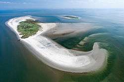
Aerial photo of Rottumeroog in 2011 | |
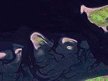
 Location of Rottumeroog in the Wadden Sea | |
| Geography | |
|---|---|
| Coordinates | 53°32′25″N 6°34′55″E / 53.54028°N 6.58194°ECoordinates: 53°32′25″N 6°34′55″E / 53.54028°N 6.58194°E |
| Archipelago | (West) Frisian Islands |
| Adjacent bodies of water | North Sea, Wadden Sea |
| Area | 265 ha (650 acres)[1] |
| Highest elevation | 12.0 m (39.4 ft)[1] |
| Administration | |
|
Netherlands | |
| Province | Groningen |
| Municipality | Eemsmond |
| Demographics | |
| Population | Uninhabited |
Rottumeroog (Dutch pronunciation: [ˌrɔtɵmərˈoːx]) is an uninhabited island in the Wadden Sea and is part of the Netherlands. The island is one of three West Frisian Islands in the province of Groningen. It is situated between the islands of Rottumerplaat and Borkum.
The island originates from the 15th or 16th century. At first the island was used for agriculture by the St. Juliana's Abbey from Rottum. Rottumeroog is now part of the natural reserve Rottum and access to the island is prohibited.
Geography
Rottumeroog is located at 53°32′25″N 6°34′55″E / 53.54028°N 6.58194°E in the municipality of Eemsmond in the north of the province of Groningen in the north of the Netherlands. It is situated off the coast of Groningen's mainland and it is the easternmost island of the West Frisian Islands in the Wadden Sea, east of the island of Rottumerplaat, north of the island of Zuiderduintjes, and west of the East Frisian island of Borkum (Germany).
Rottumeroog does not have a solid core and slowly moves in southeastern direction as a result of sea currents. On the north side, land is gradually washed away; on the south side, new land is forming. Rottumeroog had a surface area of 205 ha (510 acres) in 1995 and 265 ha (650 acres) in 2007.[1]
History

Between 1400 and 1540 CE, the island of Monnikenlangenoog had split into the islands of Bosch and Rottumeroog. Bosch had disappeared in the 18th century, but Rottumeroog still remains today.[2]
The name Rottumeroog means literally 'Island of Rottum',[3] after the village of Rottum on the mainland of Groningen. The Benedictine St. Juliana's Abbey in Rottum used to own two-thirds of the island and used it for their livestock. After the Protestant Reformation the island's rights transferred to the province Groningen before being sold to private persons in the 17th century. The province bought the island back in 1738 due to back maintenance, eventually the central government took over. Until 1965 the island was inhabited by a vogt and his family; since then the island has been uninhabited.[4]
Several buildings have been built on the island. In the 19th century the navigational beacon Emder Kaap was built. The structure is listed as a national heritage site (rijksmonument) since 1988 and was moved southwards in 1999.[4][5] The vogt had a house as well; this building was demolished in 1998 due to the encroaching North Sea.[1] In February 2014, the bird observation post was removed from the island.[6] Later in 2014 all remaining buildings on the islands, except for the Emder Kaap, were removed due to the changing shape and position of the island.[4]
The future area of the island is uncertain. In 2012, the island broke into two during high tide, giving rise to the claim that the island might disappear in the Ems estuary in the near future.[7]
Natural reserve

The Wadden Sea, in which Rottumeroog is situated, is a UNESCO World Heritage Site (natural criteria viii, ix, and x) since 2009.[8]
Together with Rottumerplaat and Zuiderduintjes, the island forms the natural reserve Rottum. The island is generally not maintained, the shape and position are left for nature to change. The island is uninhabited and access is usually prohibited; several excursions to the islands are allowed each year under strict conditions.[1]
The island is home to birds and grey seals.[9]
References
- 1 2 3 4 5 (Dutch) Beheerregeling Rottum, Rijkswaterstaat, 2010. Retrieved on 1 May 2014.
- ↑ (Dutch) "Verzonken waddeneiland Moenkenlangenoe ontdekt", Dagblad van het Noorden, 2012. Retrieved on 27 April 2014.
- ↑ Mares Bijwaard, "Geschiedenis Rottumeroog", IsGeschiedenis, 2014. Retrieved 4 November 2015.
- 1 2 3 (Dutch) Aarsbergen, Aart; Doest, Jasper (2014). "Het onbewoonde Rottumeroog" [The uninhabited Rottumeroog]. nationalgeographic.nl (in Dutch). National Geographic. Retrieved 27 May 2014.
- ↑ (Dutch) Monumentnummer: 338545 – Zeekaap, Rijksdienst voor het Cultureel Erfgoed. Retrieved on 1 May 2014.
- ↑ (Dutch) "Sloop vogelwachterhuis bijna voltooid", Dagblad van het Noorden, 2014. Retrieved on 1 May 2014.
- ↑ "Waddeneiland Rottumeroog dreigt in zee te verdwijnen" [Frisian Island Rottumeroog might disappear into sea]. Elsevier (in Dutch). 14 March 2012. Retrieved 28 May 2014.
- ↑ The Wadden Sea, UNESCO World Heritage Centre. Retrieved on 1 May 2014.
- ↑ (Dutch) Rottum > Flora en fauna, Staatsbosbeheer. Retrieved on 1 May 2014.
External links
-
 Media related to Rottumeroog at Wikimedia Commons
 - (Dutch) Friends of Rottumeroog and Rottumerplaat Foundation
| West Frisian Islands (Netherlands) |
|  | |||||||||
|---|---|---|---|---|---|---|---|---|---|---|---|
| East Frisian Islands (Germany) |
| ||||||||||
| Heligoland Bight (Germany) | |||||||||||
| North Frisian Islands (Germany) |
| ||||||||||
| Danish Wadden Sea Islands (Denmark) |
| ||||||||||