Rotherhithe
| Rotherhithe | |
 The tower of St Mary's Church, Rotherhithe |
|
 Rotherhithe |
|
| Population | 13,743 (2011 Census. Ward)[1] |
|---|---|
| OS grid reference | TQ358796 |
| London borough | Southwark |
| Ceremonial county | Greater London |
| Region | London |
| Country | England |
| Sovereign state | United Kingdom |
| Post town | LONDON |
| Postcode district | SE16 |
| Dialling code | 020 |
| Police | Metropolitan |
| Fire | London |
| Ambulance | London |
| EU Parliament | London |
| UK Parliament | Bermondsey and Old Southwark |
| London Assembly | Lambeth and Southwark |
Coordinates: 51°29′56″N 0°02′33″W / 51.4989°N 0.0426°W
Rotherhithe (/ˈrɒðərhaɪð/) is a residential district in south east London, England, and part of the London Borough of Southwark. It is located on a peninsula on the south bank of the Thames, facing Wapping and the Isle of Dogs on the north bank, and is a part of the Docklands area. It borders Bermondsey to the west and Deptford to the south east.
Rotherhithe has a long history as a port, with many shipyards from Elizabethan times until the early 20th century and with working docks until the 1970s. In the 1980s the area along the river was redeveloped as upmarket housing, through a mix of warehouse conversions and new-build developments. Following the arrival of the Jubilee line in 1999 (giving quick connections to the West End and to Canary Wharf) and the London Overground in 2010 (providing a quick route to the City of London), the rest of Rotherhithe is now a rapidly gentrifying residential and commuter area, with current regeneration progressing well around Downtown Road/Rotherhithe Street area and most quickly around Deal Porter Square[2] at Canada Water, where a new town centre with restaurant and retail units as well as new residential developments is emerging around the existing freshwater dock and transport hub.
Rotherhithe is located 4.5 km (2.8 mi) east of London's centre point. Rotherhithe, being an area of the Docklands, has the largest Chinese population in Southwark.
Etymology
The name "Rotherhithe" derives from the Anglo-Saxon Hrȳðer-hȳð meaning "landing-place for cattle".[3] The first recorded use of this name was in about 1105, as Rederheia.[3] In the past Rotherhithe was also known as Redriff or Redriffe,[4][5] however until the early 19th century, this name was applied to the whole river front from St Saviour's Dock to Bull Head Dock, this near the entrance to Surrey Water.[6]
Description
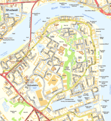
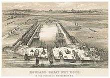

The docks were closed and largely filled in during the 1980s, and have now been replaced by modern housing and commercial facilities, but Rotherhithe retains much of its character and its maritime heritage. The largest surviving dock on the south bank, Greenland Dock, is the focal point for the southern part of the district, while there are many preserved wharves along the riverside at the north end of Rotherhithe. St. Mary's Church is at the centre of the old Rotherhithe village, which contains various historic buildings including the Brunel Engine House at the south end of the Thames Tunnel.
Canada Dock was the dock basin furthest away from the River Thames in the Surrey Docks complex, and it was linked to Albion Dock and Greenland Dock at its northern and south-eastern extremities via the Albion Canal. The dock has been remodelled, and its northwest half retained as an ornamental lake, renamed Canada Water. The canal has remained as a walkway and water feature within the redeveloped area.[7]
Rotherhithe is the home of the football team Fisher F.C., which plays its games at St Pauls Stadium. The league 1 team Millwall Football Club is located nearby in the London Borough of Lewisham.
The sustainable transport charity Sustrans has proposed the construction of a bicycle and pedestrian swing bridge from Rotherhithe to Canary Wharf, and cost-benefit and feasibility studies were undertaken. In January 2009 the London Mayor Boris Johnson said he would not fund the bridge, citing budget cuts due to the credit crunch,[8] with the result that the project was effectively put on ice. However the idea is still being supported by Sustrans.[9]
There are two Anglican churches in Rotherhithe St. Mary's Church,[10] and Trinity Church.[11][12] There are two Roman Catholic churches: St Peter and the Guardian Angels,[13] and Our Lady of the Immaculate Conception.[14]
King's Stairs Gardens
King's Stairs Gardens is a small park on the river towards the Bermondsey boundary. In September 2011 Thames Water announced that they wanted to build an access shaft for the "super-sewer" Thames Tunnel. Due to local action by The Save King's Stairs Gardens Campaign, which collected over 5000 signatures, it seems as of March 2011 that Thames Water will build the access shaft elsewhere, if the local community agrees.
Local landmarks and history

Severn Islands Leisure Centre occupies the site of the old Rotherhithe Town Hall.[15] The building ceased to be a town hall in 1905 when the former Rotherhithe Council merged with the old Bermondsey Borough Council and the new council used premises in Spa Road. The old Rotherhithe Town Hall became a library and a museum. It was razed to the ground by repeated bomb hits and near misses during the Second World War (see below).[16]
Rotherhithe had its own general hospital, St Olave's Hospital, on Lower Road close to the old town hall. Built originally in the early 1870s on land adjoining Rotherhithe Workhouse, it became the infirmary of St Olave's Union in 1875, and was renamed St Olave's Hospital in 1930. Subsequently, becoming part of the Guy's Hospital Teaching Group in 1966, it closed in 1985 and the site has been redeveloped into the residential Ann Moss Way.
When the roundabout facing the Rotherhithe Tunnel was redeveloped in the early 1980s, several 19th century buildings were demolished including a school and a nunnery. A public house, the "Europa", described in an early 20th-century history of the area as one its oldest, was also demolished. Max Bygraves frequently played piano there at weekends.
Ecclesiastical parish
The ancient parish, dedicated to St Mary, was in the Diocese of Winchester until 1877, then the Diocese of Rochester until 1905, and then finally in the Diocese of Southwark. From 1840, as the population of Rotherhithe increased, a number of new parishes were formed:[17]
- Christ Church, Rotherhithe in 1840
- All Saints, Rotherhithe in 1842
- Holy Trinity, Rotherhithe in 1842
- St Barnabas, Rotherhithe in 1873
In addition, as the population of neighbouring Deptford increased, parts of Rotherhithe parish were included in the new parish of:
- St Katherine, Rotherhithe in 1886 with parts of St James, Hatcham
Nordic connection

Because much of the former Surrey Docks had strong trade links to Scandinavia and the Baltic region the area is still home to a thriving Scandinavian community.[18] During World War II, in fact, it housed the Norwegian Government-in-Exile. Originally established as seafarers' missions, Rotherhithe is home to a Norwegian,[19] a Finnish[20] and a Swedish[21] church. The Finnish Church and the Norwegian Church are both located in Albion Street; they were built in 1958 and 1927 respectively (Rotherhithe Library is located between them). There are also a number of "community centres" for the Nordic community in London, including hostels, shops and cafés and even a sauna, mostly linked closely to the churches.
Some of the redeveloped areas were built by Nordic architects, such as the Greenland Passage development[22] by Danish Company Kjaer & Richter. This gives some areas a distinctly "Nordic" feel in terms of house and street design.
The relationship with Scandinavia and the Baltic is also reflected in the names of some of the buildings (such as the King Frederik IX Tower),[22] the street names (e.g. Finland Street, Sweden Gate, Baltic Quay, Norway Gate, Helsinki Square) or other place names (e.g. Greenland Dock). Another major influence factor was trade with Russia and Canada (mainly timber), reflected in names such as Canada Water[23] and the Russia Dock Woodland.
Indian connection
Other connections include with the Indian subcontinent, with wharves being named Bombay Court and East India court. A neo-Indian community has also now found root there with many young upcoming Indian professionals moving to London to work in the technology, financial services and legal professions. The proximity to the City and Canary Wharf has made this a convenient choice and hub for graduates from the Indian Institutes of Technology.
Other connections
Rotherhithe is also a popular place to live with South Africans according to the UK census of 2011[24] and there was a South African themed pub located at 351 Rotherhithe Street.[25]
The Mayflower
In July 1620, the Mayflower sailed from Rotherhithe for Southampton on the south coast of England, to begin loading food and supplies for the voyage to New England. At that time, the English Separatists, who later became known as the "Pilgrim Fathers", were mostly still living in the city of Leiden, in the Netherlands. There they hired a ship called the Speedwell to take them from Delfthaven in the Netherlands to Southampton to meet up with the Mayflower.[26]
The ship's captain, Christopher Jones, died shortly after his return in 1621 and he is buried in an unmarked grave at St Mary's Church. The Mayflower sailed from near a public house called the Shippe in Rotherhithe Street, which was substantially rebuilt in the 18th century, called the Spread Eagle and Crown,[27] and is now named the Mayflower.[28] The building itself, despite external and interior appearances, dates from the 1950s.[29]
China Hall
On Lower Road, about halfway between Surrey Quays and Canada Water stations, is a public house called the China Hall; at one time it was the entrance to a riparian playhouse visited by Samuel Pepys and mentioned in his diary. It is not known how long the theatre remained on the site, but it was reinvigorated in 1777 and during 1778 George Frederick Cooke acted there, but in the winter of 1779 it was destroyed in fire. The site of the theatre became a well-known tea-gardens, with the "usual arbours and 'boxes'" during the Victorian period, but by the 1920s most of the gardens had been absorbed into the Surrey Commercial Docks as part of a timber yard.[30][31]
Second World War

Like the rest of the London Docks, the Surrey Commercial Docks were targeted by the Luftwaffe. On 7 September 1940, on the first day of the London Blitz, the deal yards of Surrey Docks were set ablaze. The raid ignited over a million tonnes of timber in Quebec Yard, causing the most intense single fire ever seen in Britain.[32][33]
The bombing of the old Rotherhithe Town Hall during the Second World War gives an indication of how heavy the bombing in Rotherhithe was. The first damage to the building occurred when Luftwaffe bombs landed nearby in April 1941, and there was more bomb damage in February and June 1944. Later the same month (June 1944) the Town Hall was very severely damaged by a direct hit by a V1 doodlebug. In November 1944 it was further damaged by near misses, and it was finally destroyed by one of the last V1s to land on London during the Second World War.[34]
King Haakon VII made many of his famous radio broadcasts to occupied Norway from Saint Olav's Norwegian Church in Rotherhithe, where the Norwegian Royal Family were regular worshippers during their exile in London.[35]
Geography
Rotherhithe is joined to the north bank of the Thames by three tunnels. The Thames foot tunnel to Wapping was the first underwater tunnel in the world.[36] Built by the Brunels and originally intended to carry cross-river freight, it became a pedestrian tunnel, due to the money running out to build the necessary ramps for vehicle traffic. It was used as a railway tunnel from 1869, and is now part of the London Overground network, which on 27 April 2010 started running trains on the route of the former East London Line. The later Rotherhithe Tunnel (opened 1908) carries a two-lane road to Limehouse. The Jubilee line extension (opened 1999) has a railway tunnel to Canary Wharf in the Isle of Dogs.
Parts of Rotherhithe Street were at one time or another called Jamaica Street, Lavender Street, Low Queen Street, Queen Street, Redriff Wall, Redriff, Rotherhithe Wall, Shipwright Street and Trinity Street.[6]
Rotherhithe is part of the SE16 postcode district. Electorally, the western half is Rotherhithe ward of Southwark London Borough Council and the eastern half in Surrey Docks ward.
As much of Rotherhithe was occupied by the now-defunct Surrey Commercial Docks, the district is sometimes referred to as "Surrey Docks" or (since the late 1980s) "Surrey Quays", though the latter name tends to be used more for the southern half of the peninsula. An eastern part, which became an island when the docks were in use and the locks open, is called "Downtown". This name was never related to the idea of a "downtown" in the American sense, although there was a club of that name there for many years which has now closed. This part of Rotherhithe has since the 1980s been quiet and suburban in nature. Durand's Wharf is a park located in Rotherhithe Street and holds an Outdoor Gym[37]
|

Notable people

- Marc Isambard Brunel (1769–1849) and his son Isambard Kingdom Brunel (1806–1859) built the Thames Tunnel between Rotherhithe and Wapping.
- Max Bygraves (1922–2012), entertainer, was born in Rotherhithe.
- Michael Caine (born 1933), actor, was born Maurice Joseph Micklewhite in Rotherhithe.
- Thomas Coram (1668–1751) a philanthropic sea captain, retired to Rotherhithe where he campaigned for establishment of the Foundling Hospital.[38]
- Eliza Fay (1755 or 1756–1816), author of Original Letters from India (1817),[39] was born in Rotherhithe.
- Malcolm Hardee (1950–2005), comedian, lived on a houseboat in Greenland Dock, Rotherhithe. He owned and ran the Wibbley Wobbley pub-boat on the same dock, and was drowned there.
- Alfred Hitchcock (1899–1980) filmed scenes in Rotherhithe for his first film as a director, Number 13 (1922), before it was pulled from production.
- Myleene Klass (born 1978), singer, lived in Rotherhithe in the early 2000s.
- Aaron Manby (1776–1850) assembled and launched the world's first seagoing iron-hulled ship at Rotherhithe in 1822.
- Princess Margaret (1930–2002) met her future husband, photographer Tony Armstrong-Jones, in a house in Rotherhithe.
- Billy Mehmet (born 1985), professional footballer, attended Bacon's College in Rotherhithe in the 1990s.
- King Mutesa II of Buganda (1925–1969) died in exile in his flat in Rotherhithe in 1969 following an interview with journalist John Simpson.
- James Walker (1781–1862) worked on the design and construction of Greenland Dock, where a memorial bust of him stands.
In popular culture
- In the popular television drama series Upstairs, Downstairs the character James Bellamy stands as a Conservative Party candidate for the constituency of Rotherhithe East.
- The James Bond film Tomorrow Never Dies used Harmsworth Quays Printing as the scene for Carver's print works.
- Redriff was the fictional birthplace of Jonathan Swift's character Lemuel Gulliver, of Gulliver's Travels fame, and where his family waited for him.
- Rotherhithe is alluded to in the British Sea Power song Carrion and the Elvis Costello song New Amsterdam.
- Adam Carter from Spooks supposedly lives in Canada Wharf on Rotherhithe Street, and much of the series is filmed on locations around Rotherhithe and the Docklands.
- The final chapter of Charles Dickens's Oliver Twist (1839) provides a lively depiction of a Rotherhithe slum-district of the mid-19th century.
- The famous Gujarati poem, 'Rajashahi Ghodi', talks about a bicycle, allegorically a royal steed as it passes by the narrow by-lanes of Rotherhithe every morning, describing landmarks and monuments like the Mayflower Pub, the Picture Library and Southwark Park, along its way.
- A song from the musical Cats, "Growltiger's Last Stand", mentions the cottagers of Rotherhithe.
- "The man from Rotherhithe" is an unnamed, recurring character in the long poem In Parenthesis by David Jones.
- A period costumier, picture library and minor film producer Sands Films is located at Rotherhithe Street, close to the Mayflower pub.
- Long-running ITV series London's Burning was based at local fire station Dockhead for the first few series, with most scenes filmed in Bermondsey and Rotherhithe. For example, leading character 'Vaseline' was filmed drowning in Greenland Dock, and another leading character, Bert, campaigned to save the local city farm, filmed at Surrey Docks Farm in Rotherhithe.
- The 2004-2005 ITV drama series The Brief often filmed in Rotherhithe, with internal scenes filmed at the Mayflower pub. Lead character Henry Farmer, played by Alan Davies, lived a few doors away.
- 2007 film "The Riddle", starring Vinnie Jones and Derek Jacobi, was largely filmed on location in Rotherhithe. It features the interior and exterior of the genuine Blacksmiths Arms, Rotherhithe, although the rear of the pub in the film was a temporary set built adjacent to the Downtown nightclub, close to the Surrey Docks Farm.
- In "The Adventure of The Dying Detective", Sherlock Holmes pretends to Dr. Watson that he has contracted a contagious disease in Rotherhithe, while working on a case.
- The first and last episodes of Dempsey and Makepeace were filmed at the Mayflower public house and in the area.
Main sights
Transport
Rotherhithe is served by three stations. Near the river, in the north, Rotherhithe, formerly a London Underground station, was rebuilt as a London Overground station, and reopened on 27 April 2010, together with Surrey Quays to the south. In between lies Canada Water in central Rotherhithe. Canada Water station is now an important transport interchange, as it connects the London Overground (formerly East London line) and the Jubilee line of the London Underground, as well as having a bus station. This station is at the centre of a major regeneration project, with rapid construction of new flats. Other nearby stations are Bermondsey (also on the Jubilee line), South Bermondsey railway station to the south west, and London Bridge railway station to the west.
- Walking and cycling
The riverbank carries part of the Richmond to Thames Barrier (28 miles – 45 km) section of the Thames Path through London. Most of the riverbank is accessible, apart from sections where warehouses and estates have established rights to the riverside.
A new bridge for pedestrians and cyclists has been proposed between Rotherhithe and Canary Wharf.
- Buses
The area is served by TfL bus services 1, 47, 188, 199, 225, 381, C10 and P12; and night buses N1, N199 and N381.[40]
- Taxis
London Taxis (black cabs) can often be found on Salter Road.
- River boat service piers
- Greenland Dock Pier serviced by Thames Clippers'
- Docklands Pier for Canary Wharf – Rotherhithe Ferry only
| Preceding station | London River Services | Following station | ||
|---|---|---|---|---|
Terminus | Rotherhithe to Canary Wharf Service | Terminus | ||
toward Embankment Pier | Commuter Service | toward Woolwich Arsenal Pier |
Gallery
| Wikimedia Commons has media related to Rotherhithe. |
 Mayflower public house
 Albion Channel
 Riverside developments
 View from Stave Hill towards Canary Wharf
 Russia Dock woodland
References
- ↑ "Southwark Ward population 2011". Neighbourhood Statistics. Office for National Statistics. Retrieved 13 October 2016.
- ↑ "Canada Water Plaza - Canada Water Plaza". Southwark Council. 27 July 2010. Retrieved August 2015. Check date values in:
|access-date=(help) - 1 2 A Dictionary of British Place-Names, A.D. Mills Rotherhithe, Oxford University Press, 2003, ISBN 0-19-283131-3
- ↑ BBC London, A Thames Tour of Rotherhithe
- ↑ John Wells’s phonetic blog, Redriff, 31 October 2007
- 1 2 Shipbuilding in Rotherhithe – An historical introduction by Stuart Rankin
- ↑ http://www.jbutler.org.uk/London/Southwark/Rotherhithe.shtml
- ↑ Sustrans London Route News accessed 4 July 2007
- ↑ "Brunel Bridge – a proposed pedestrian and cycling bridge between Rotherhithe and Canary Wharf". brunelbridge.london. Retrieved August 2015. Check date values in:
|access-date=(help); External link in|publisher=(help) - ↑ "St. Mary the Virgin - Rotherhithe". Retrieved December 2013. Check date values in:
|access-date=(help) St Marychurch Street, SE16 4JE - ↑ Father Andrew Doyle, Vicar. (December 2013). "Holy Trinity Rotherhithe". Bryan Road, SE16 5HF
- ↑ Andie Byrnes (20 June 2013). "A history of Trinity Church, Rotherhithe".
- ↑ "St Peter and the Guardian Angels". 72 Paradise St, SE16 4QD
- ↑ "Our Lady of the Immaculate Conception". St. Elmos Road, SE16 6SJ
- ↑ Henden, Stephen. "V1 & V2 logs SE16 Rotherhithe and Bermondsey". Retrieved October 2011. Check date values in:
|access-date=(help) - ↑ Blackman, James (28 May 2009). "Bring the statues back home to Rotherhithe". Southwark News.
- ↑ , 'Parishes: Rotherhithe', A History of the County of Surrey: Volume 4 (1912), pp. 83-92. Date accessed: 10 March 2014.
- ↑ http://www.independent.co.uk/travel/news-and-advice/48-hours-in-scandinavian-london-5365972.html
- ↑ Norwegian Church and Seamen's Mission, St Olav's Church accessed 4 July 2007
- ↑ The Finnish Church in London accessed 4 July 2007
- ↑ The Swedish Church in London accessed 4 July 2007
- 1 2 Greenland Passage development accessed 4 July 2007
- ↑ Canada Water Campaign and Canada Water Consultative Forum accessed 4 July 2007
- ↑ "DataShine: Census". Retrieved 2015-09-04.
- ↑ "Orange Bull, Rotherhithe".
- ↑ www.mayflower.com Route and Maps of the Voyage
- ↑ "The Mayflower". BBC. Retrieved 3 September 2015.
- ↑ "Mayflower". pubs.com. Retrieved 21 January 2009.
- ↑ Pevsner, Bridget Cherry & Nikolaus (2002). London. ([New ed.] ed.). New Haven, Conn.: Yale University Press. ISBN 978-0300096514.
- ↑ Wagner, Leopold (1921). A new book about London: a quaint and curious volume of forgotten lore. London: Allen & Unwin. pp. 190,191.
- ↑ Beck, Edward Josselyn; Bonney, Thomas George (1907). Memorials to serve for a history of the parish of St. Mary, Rotherhithe in the county of Surrey and in the administrative county of London. Cambridge University Press. pp. Appendix 259,260.
- ↑ Stansky, Peter (2007). The first day of the blitz: September 7, 1940 (illustrated ed.). Yale University Press. p. 81. ISBN 0-300-12556-9.
- ↑ Harris, Clive; Bright, Neil (2010). A Guide to Wartime London: Six Walks Revisiting the Blitz (illustrated ed.). Casemate Publishers. pp. 69–70. ISBN 9781848841727.
- ↑ Blackman 2009.
- ↑ The Diocese of Southwark, The Bridge, December 2009 - January 2010: Scandinavia in Rotherhithe
- ↑ McKenzie, Greg (12 March 2010). "World's oldest underwater tunnel opened to public". bbc.co.uk. Retrieved 26 September 2013.
- ↑ "Outdoor Gyms". Leisure and Culture. London Borough of Southwark. Retrieved 3 September 2015.
- ↑ Harris, Rhian (5 October 2012). "The Foundling Hospital". BBC.
- ↑ Original Letters from India (New York: NYRB, 2010 [1925]), ed. E. M. Forster. ISBN 1-59017-336-8]
- ↑ "Buses from Rotherhithe" (PDF). TfL. Retrieved March 2013. Check date values in:
|access-date=(help)
Further reading
- BBC London Coast – Rotherhithe Walk
- Canada Water Campaign
- Canada Water Plaza
- Friends of Russia Dock Woodland
- LDDC Completion Booklets Surrey Docks
- London Voices Rotherhithe, Surrey Docks, Surrey Quays, London SE16
- Londonist Discovers Rotherhithe Picture Research Library
- Maritime Rotherhithe Walk A: Transport, Industry and the Docks by Stuart Rankin, Southwark, 2004, ISBN 0-905849-40-X
- Maritime Rotherhithe Walk B: Shipyards, Granaries and Wharves by Stuart Rankin, Southwark, 2004, ISBN ISBN 0-905849-37-X
- Save King's Stairs Gardens Campaign
- SE16 online community
- The Finnish Church in London
- The National Archives database record for St Olave's Hospital
Maps
History
- British History Online The Environs of London: volume 1, Rotherhithe, County of Surrey, pp. 470–477, Daniel Lysons, 1792
- British History Online Old and New London: Volume 6, Rotherhithe, pp. 134–142, Edward Walford, 1878
- British History Online A History of the County of Surrey: Volume 4, Parishes: Rotherhithe, pp. 83–92, H.E. Malden (editor), 1912,
- Henden, Stephen. "V1 & V2 logs SE16 Rotherhithe and Bermondsey". Flying Bombs and Rockets. Retrieved 26 November 2010.
| Districts |  | |
|---|---|---|
| Attractions |
| |
| Markets | ||
| Bridges and tunnels | ||
| Parks and open spaces |
| |
| Constituencies | ||
| Tube and rail stations | ||
| Other topics | ||