Roseto, Pennsylvania
| Borough of Roseto | |
| Settlement | |
 Roseto Presbyterian Church | |
| Country | United States |
|---|---|
| State | Pennsylvania |
| County | Northampton |
| Elevation | 794 ft (242.0 m) |
| Coordinates | 40°52′50″N 75°13′02″W / 40.88056°N 75.21722°WCoordinates: 40°52′50″N 75°13′02″W / 40.88056°N 75.21722°W |
| Area | 0.6 sq mi (1.6 km2) |
| - land | 0.6 sq mi (2 km2) |
| - water | 0.0 sq mi (0 km2), 0% |
| Population | 1,653 (2000) |
| Density | 1,067.8/sq mi (412.3/km2) |
| Timezone | EST (UTC-5) |
| - summer (DST) | EDT (UTC-4) |
| ZIP Code | 18013 |
| Area code | 610 and 484 |
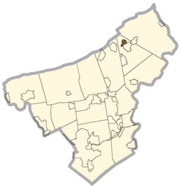 Location of Roseto in Northampton County | |
 Location of Roseto in Pennsylvania | |
 Location of Pennsylvania in the United States | |
Roseto is a borough in Northampton County, Pennsylvania, United States. Roseto is located in the Lehigh Valley region of the state. It is part of Pennsylvania's Slate Belt.
The population of Roseto was 1,653 at the 2000 census.
History
The town is named for the village of Roseto Valfortore in Italy. It was largely settled by German, Dutch and Italian Americans employed at the numerous local slate quarries. The Wind Gap and Delaware Railroad opened a line through the town in 1883. It was operated by the Central Railroad of New Jersey until 1905, after which it was merged into the Lehigh and New England Railroad, which abandoned the line in 1955. It was incorporated as a borough in 1912.[1]
Roseto is known in the fields of sociology and cardiology for the Roseto effect, wherein the close-knit community exhibited half the national average rate of heart disease in the mid-20th century. This finding helped to establish that stress can contribute to heart disease.[2]
Geography
Roseto is located at 40°52′50″N 75°13′2″W / 40.88056°N 75.21722°W (40.880576, -75.217345).[3]
According to the United States Census Bureau, the borough has a total area of 0.6 square miles (1.6 km2), all of it land.
Demographics
| Historical population | |||
|---|---|---|---|
| Census | Pop. | %± | |
| 1920 | 1,634 | — | |
| 1930 | 1,746 | 6.9% | |
| 1940 | 1,778 | 1.8% | |
| 1950 | 1,676 | −5.7% | |
| 1960 | 1,630 | −2.7% | |
| 1970 | 1,538 | −5.6% | |
| 1980 | 1,484 | −3.5% | |
| 1990 | 1,555 | 4.8% | |
| 2000 | 1,653 | 6.3% | |
| 2010 | 1,567 | −5.2% | |
| Est. 2015 | 1,549 | [4] | −1.1% |
| Sources:[5][6][7] | |||
As of the census[6] of 2000, there were 1,653 people, 640 households, and 476 families residing in the borough. The population density was 2,634.5 people per square mile (1,013.1/km2). There were 670 housing units at an average density of 1,067.8 per square mile (410.6/km2). The racial makeup of the borough was 98.85% White, 0.36% Asian, 0.18% African American, 0.18% from other races, and 0.42% from two or more races. Hispanic or Latino of any race were 1.94% of the population.
There were 640 households, out of which 33.6% had children under the age of 18 living with them, 57.3% were married couples living together, 11.7% had a female householder with no husband present, and 25.6% were non-families. 22.2% of all households were made up of individuals, and 11.4% had someone living alone who was 65 years of age or older. The average household size was 2.58 and the average family size was 3.04.
In the borough the population was spread out, with 25.2% under the age of 18, 7.1% from 18 to 24, 28.9% from 25 to 44, 19.2% from 45 to 64, and 19.5% who were 65 years of age or older. The median age was 38 years. For every 100 females there were 89.3 males. For every 100 females age 18 and over, there were 87.3 males.
The median income for a household in the borough was $39,813, and the median income for a family was $45,833. Males had a median income of $36,563 versus $21,750 for females. The per capita income for the borough was $17,419. About 5.7% of families and 7.2% of the population were below the poverty line, including 9.4% of those under age 18 and 8.7% of those age 65 or over.
Public education
The borough is served by the Bangor Area School District.
Gallery
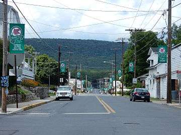 Garibaldi Street in Roseto.
 Roseto Municipal Building.
 General Sewing Machine Co.
References
- ↑ Bianco, Carla (1974). The Two Rosetos. Bloomington, Indiana: University of Indiana Press. ISBN 0-253-18992-6.
- ↑ Gladwell, Malcolm (2008). Outliers: The Story of Success. ISBN 978-0-316-01792-3.
- ↑ "US Gazetteer files: 2010, 2000, and 1990". United States Census Bureau. 2011-02-12. Retrieved 2011-04-23.
- ↑ "Annual Estimates of the Resident Population for Incorporated Places: April 1, 2010 to July 1, 2015". Retrieved July 2, 2016.
- ↑ "Census of Population and Housing". U.S. Census Bureau. Retrieved 11 December 2013.
- 1 2 "American FactFinder". United States Census Bureau. Retrieved 2008-01-31.
- ↑ "Incorporated Places and Minor Civil Divisions Datasets: Subcounty Resident Population Estimates: April 1, 2010 to July 1, 2012". Population Estimates. U.S. Census Bureau. Retrieved 11 December 2013.
| Wikimedia Commons has media related to Roseto, Pennsylvania. |
Municipalities and communities of Northampton County, Pennsylvania, United States | ||
|---|---|---|
| Cities | 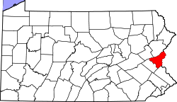 | |
| Boroughs | ||
| Townships | ||
| CDPs | ||
| Unincorporated communities | ||
| Footnotes | ‡This populated place also has portions in an adjacent county or counties | |