Rommerskirchen
| Rommerskirchen | ||
|---|---|---|
|
Rommerskirchen | ||
| ||
 Rommerskirchen | ||
Location of Rommerskirchen within Rhein-Kreis Neuss district 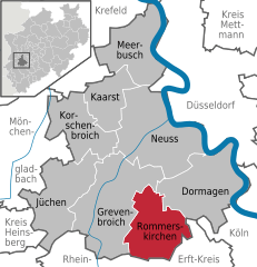
 | ||
| Coordinates: 51°2′5″N 6°41′29″E / 51.03472°N 6.69139°ECoordinates: 51°2′5″N 6°41′29″E / 51.03472°N 6.69139°E | ||
| Country | Germany | |
| State | North Rhine-Westphalia | |
| Admin. region | Düsseldorf | |
| District | Rhein-Kreis Neuss | |
| Government | ||
| • Mayor | Dr. Martin Mertens (SPD) | |
| Area | ||
| • Total | 60.99 km2 (23.55 sq mi) | |
| Population (2015-12-31)[1] | ||
| • Total | 13,137 | |
| • Density | 220/km2 (560/sq mi) | |
| Time zone | CET/CEST (UTC+1/+2) | |
| Postal codes | 41569 | |
| Dialling codes | 02183, 02182, 02181 | |
| Vehicle registration | NE | |
| Website | www.rommerskirchen.de | |


Rommerskirchen is the southernmost municipality in the Rhein-Kreis Neuss, in North Rhine-Westphalia, Germany.
Notable places
Rommerskirchen possesses rich historical inheritances, including numerous remains of the Roman Villae Rusticae, and those from several Frankish settlements. The town centre still contains several medieval Roman and Gothic churches and a castle. There are many buildings from even earlier modern times, as well as those from the time of the Napoleonic occupation. Many of these sites are currently closed while undergoing restoration.
Infrastructure
Rommerskirchen is the location of a large 380kV-substation of the RWE. The first 380kV-line in Germany went into service on October 5, 1957. It began between the transformer stations of Rommerskirchen and Ludwigsburg-Hoheneck. The strategic railway embankment begins at Rommerskirchen station, and Oekoven maintains a public railway facility. Rommerskirchen generally mean Roman Catholic Church.
References
- ↑ "Amtliche Bevölkerungszahlen". Landesbetrieb Information und Technik NRW (in German). 18 July 2016.
External links
- Official site (German)
Towns and municipalities in Rhein-Kreis Neuss | ||
|---|---|---|