Romblon, Romblon
| Romblon | |
|---|---|
| Municipality | |
|
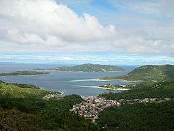
Romblon town and Romblon Bay | |
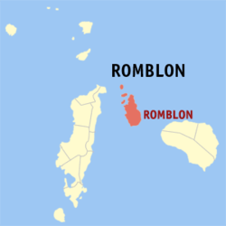 Map of Romblon Province with Romblon Municipality highlighted | |
.svg.png) Romblon Location within the Philippines | |
| Coordinates: 12°34′N 122°16′E / 12.567°N 122.267°ECoordinates: 12°34′N 122°16′E / 12.567°N 122.267°E | |
| Country | Philippines |
| Region | MIMAROPA (Region IV-B) |
| Province | Romblon |
| District | Lone district |
| Founded | 1571 (as encomienda) |
| 1631 (as pueblo) | |
| Barangays | 31 |
| Government[1] | |
| • Type | Municipal |
| • Mayor | Mariano M. Mateo (NP)[2] |
| • Vice Mayor | Mac-Mac Silverio (NP) |
| • Councilors |
Wiwet Rugas Nene Lim Orly Magano Raymund Robis Pido Riano Melben Mesana Toing Morante Jun Mariño |
| Area[3] | |
| • Total | 86.87 km2 (33.54 sq mi) |
| Highest elevation[4] | 444 m (1,457 ft) |
| Population (2015)[5] | |
| • Total | 38,758 |
| • Density | 450/km2 (1,200/sq mi) |
| Time zone | PST (UTC+8) |
| Zip Code | 5500 |
| Dialing code | 42 |
| Income class | 3rd Class[6] |
Romblon is a third-class municipality and capital of Romblon province. In the 2015 census, it had a population of 38,758 inhabitants.[5][7] Romblomanon or Ini is the native language of its residents.
History
Early history
Romblon Island, seat of the municipality of Romblon, is one of the three major islands of Romblon province. The islands were first visited by Spanish conquistador Martin de Goiti in late 1569, and were thereafter organized by the Spanish into encomiendas. The encomienda of Donblon (Romblon), established on April 24, 1571, was granted to Don Gonzalo Riquel. In the first census done by Spanish navigator Miguel de Loarca in 1582, Romblon Island was shown to have 240 residents engaged in wax gathering.[8]
In 1631, during the term of Spanish Governor-General Juan Niño de Tabora, Romblon was established as a pueblo, making it one of the two oldest settlements in the province, the other being Banton located in the north of the province.[8] It received its first Spanish missionaries in the 17th century. During the 17th and 18th centuries, it was often ravaged by Moros.
It was organized into a Comandancia (a province or district under military control[9]) by the Spanish in 1853.
Modern history
In 1901, the American occupation saw the establishment of a civilian government in the town.[10] Ten new barrios were created while three existing barrios were also abolished. These include Aglomiom which was merged to Sablayan due to its small population, Embarcacion which was attached again to El Pueblo or Poblacion and the inland barrio of Cogon which was reorganized and split into five barrios of Tambac, Ilauran, Macalas, Lamao, and Agbaluto (referred collectively as TIMLA, from its initial letters) while barrio Alfonso XIII was renamed Calabogo.
The ten additional barrios were Bagacay, Agbudia, Agtongo, Embarcacion, Maria Cristina (renamed as Sawang) and the five new TIMLA barrios. These barrios aside from TIMLA were Agtongo which was created into a separate barrio in 1916 taken from Cajimos while in 1918 those engaged in maritime industry which were designated separately as distinct barrio known as Embarcacion was annexed again to barrio Poblacion or El Pueblo in 1939. Agbudia was the last barrio to be created taken from Guimpingan in 1939. Meanwhile, the two barrios Majabangbaybay and Sogod, located in Tablas island, were returned to Badajoz (now San Agustin), abolished as independent barrios and attached as sitios of barrio Guinpuc-an (Carmen) in 1901.
During World War II, an American force landed in the island on March 11, 1945 and liberated it from the occupying Japanese forces. By March 18, the entire province was liberated from the Japanese. A monument located near the beach in Sawang commemorates this event.
In 1960, the island barrio of Nagoso was renamed Cobrador while in 1975, the urban barangay of Poblacion was split into four separate barangays, named simply as Barangays 1, 2, 3, and 4.
Geography
The municipality consists primarily of Romblon Island, as well as the smaller Alad, Cobrador, and Logbon Islands. The municipality is situated along the coast of Romblon Bay, a natural harbor and safe haven for ships passing in the area during inclement weather. The highest peak is Mount Lagting in barangay Sablayan with a height of 444 metres (1,457 ft).[4]
Barangays
Romblon is politically subdivided into 31 barangays.[7]
- Agbaluto
- Agpanabat
- Agbudia
- Agnaga
- Agnay
- Agnipa
- Agtongo
- Alad (island barangay)
- Bagacay
- Cajimos
- Calabogo
- Capaclan
- Ginablan
- Guimpingan
- Ilauran
- Lamao
- Li-o
- Logbon (island barangay)
- Lunas
- Lonos
- Macalas
- Mapula
- Cobrador (Naguso)
- Palje
- Barangay I (Pob.)
- Barangay II (Pob.)
- Barangay III (Pob.)
- Barangay IV (Pob.)
- Sablayan
- Sawang
- Tambac
Demographics

| Population census of Romblon | ||
|---|---|---|
| Year | Pop. | ±% p.a. |
| 1960 | 16,708 | — |
| 1970 | 21,717 | +2.65% |
| 1980 | 24,251 | +1.11% |
| 1990 | 29,983 | +2.14% |
| 1995 | 34,290 | +2.55% |
| 2000 | 36,612 | +1.41% |
| 2007 | 37,544 | +0.35% |
| 2010 | 37,995 | +0.44% |
| 2015 | 38,758 | +0.38% |
| Source: National Statistics Office[5] | ||
Romblomanons are the indigenous inhabitants of Romblon. They are part of the wider Visayan ethnolinguistic group, who constitute the largest Filipino ethnolinguistic group. In 2015, there were 38,758 people living in Romblon. Most Romblomanons speak Ini, one of the three languages in the province after Asi and Onhan.
Local government

Pursuant to Chapter II, Title II, Book III of Republic Act 7160 or the Local Government Code of 1991,[11] the municipal government is composed of a mayor (alkalde), a vice-mayor (bise alkalde) and members (kagawad) of the legislative branch Sangguniang Bayan alongside a secretary to the said legislature, all of which are elected to a three-year term and are eligible to run for three consecutive terms. The incumbent mayor is Mariano M. Mateo and the vice mayor is Mac-Mac Silverio. Both are from Nacionalista Party.
| Period | Mayor | Vice mayor |
|---|---|---|
Provincial Government
As the capital of the province, the Romblon Provincial Capitol is situated in the municipality, where the governor, the vice governor, and the Sangguniang Panlalawigan takes office. It is located in Barangay Capaclan.
Transportation
By sea
Romblon is accessible via RORO vessels that ply the Manila-Odiongan, Batangas City-Odiongan, or the Roxas-Odiongan route. From Odiongan, Romblon can be reached by jeepney and motorized boat via San Agustin, Romblon.[14] There are also direct RORO routes from Manila to Romblon as well as Batangas City and Romblon.[14]
By air
The closest airport with active airline service is Tugdan Airport in Alcantara, Romblon. As of August 2014, Fil-Asian Airways offers four weekly flights[15] while SkyJet offers charter flights[16] to Romblon from Manila. From Alcantara, Romblon can be reached in 3–4 hours by jeepney and an hour by motorized boats from San Agustin.
Tourism
The capital town of Romblon is rich political and religious history as well as natural beauty. Some of the places worth visiting in the municipality include:
- St. Joseph's Cathedral and Belfry: One of the oldest Roman Catholic Church is located in barrio Poblacion. It was constructed for the Recollect Fathers between 1640 and 1726 by talented local artisans using coral blocks and bricks.
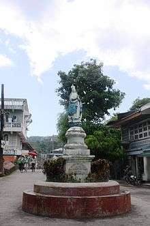
- Fuente de Belen: Located across the municipal hall, Fuente de Belen is a water fountain erected in 1864 by Eduardo Asuero. It is the source of fresh water for Romblon during the Spanish colonial period. Atop the fountain is an image of the Blessed Virgin Mary.
- Old Municipal Building: Built out of coral limestone during the Spanish colonial era, it housed the cuartel or headquarters of the local Guardia Civil. Retaining the old architecture of the building, the municipal hall is still used to house government offices and the municipal jail.[17]
- Bishop's Palace or Villa del Mar: Located in barangay Lonos, it serves as the official residence of the Bishop of Romblon. It was constructed out of clay bricks by the first bishop of Romblon, Msgr. Nicolas Mondejar
- Talipasak Beach Resort: It is located 13 kilometers from town in barangay Ginablan and offers a quiet and restful place for tourists. Activities include swimming, snorkeling, beach combing, and island hopping.
- Tiamban Beach: Located some 5 kilometers from the town proper, this fine white sand beach in barangay Lonos stretches to about 50 meters.
- Forts San Andres and Santiago: Twin Spanish forts constructed out of coral blocks and bricks between 1644 and 1573, which overlook the whole town and harbor at 156 feet above sea level. These served as a bastion to protect the people against Muslim raiders and Dutch pirates.
- Marble Beach Resort: Located in Barangay Ginablan, it is a perfect spot for nature lovers.
- Bonbon Beach: Located five kilometers away from town proper this shoreline in Barangay Lonos is covered with fine white sand and features a gradually sloping ocean floor free of sea grass and sharp stones.
- Nagoso Cave: Located in barangay Cobrador, it is the largest natural cave in the islands and believed to be an ancient burial ground as manifested by pottery and ancient works of arts found inside.
- Cobrador Beach: Barangay Cobrador's treasure is its beaches. This is located in the eastern side of the islet and has fine white sand and crushed corals.
- Romblon Harbor: It offers a perfect shelter for sea vessels since Spanish colonial period. Lying off the bay is a sunken galleon and the wreck of a Japanese battleship.
- Marble quarries and factories: Anyone interested in how Romblon marble is made can take a tricycle from the town proper to the marble quarries and factories. Romblon's marble can be compared to Italy's carara. It comes in a spectrum of shades ranging from white to black with a gamut of in-between tints like mottled white, tiger white, onyx and jade.
References
- ↑ "Municipalities". Quezon City, Philippines: Department of the Interior and Local Government. Retrieved 31 January 2013.
- 1 2 "ROMBLON - ROMBLON - City/Municipality Results - Eleksyon2016 - Results -".
- ↑ "Province: Romblon". PSGC Interactive. Makati City, Philippines: National Statistical Coordination Board. Retrieved 31 January 2013.
- 1 2 Milex Fabula. "Romblon". Romblon Travel Guide. romblon.homestead.com. Retrieved 4 February 2013.
- 1 2 3 "Total Population by Province, City, Municipality and Barangay: as of May 1, 2010" (PDF). 2010 Census of Population and Housing. National Statistics Office. Retrieved 31 January 2013.
- ↑ "Municipality/City: ROMBLON (Capital)". Philippine Statistics Authority. Retrieved 2 October 2015.
- 1 2 "Municipality/City: ROMBLON (Capital)". National Statistics office of the Philippines. 2010.
- 1 2 "History of Carmen including Historical and Cultural Background of North-eastern Barangays of the Municipality of San Agustin, Romblon." Romblon Municipal Library
- ↑ "comandancia". Merriam-Webster online dictionary. External link in
|work=(help) - ↑ Merriam-Webster, Inc (1997). Merriam-Webster's geographical dictionary. Merriam-Webster. pp. 1001. ISBN 978-0-87779-546-9.
- ↑ "An act providing for a local government code of 1991". 8th Congress of the Republic of the Philippines. Retrieved April 21, 2014.
- 1 2 "2013 Election Results: Romblon, Romblon - Comelec Live Data - Philippine National and Local Elections - Updated Real Time".
- ↑ "Philippines 2010 Elections Results". Archived from the original on 2016-05-30.
- 1 2 "How to get to Romblon". Romblon Lifestyles. Archived from the original on 2015-02-28. Retrieved 11 August 2014.
- ↑ "Fil-Asian Airways completes inaugural flight". Philippine Flight Network. 24 June 2013. Retrieved 11 August 2014.
- ↑ "SkyJet to make Romblon accessible to tourists". Philippine Flight Network. 3 July 2013. Retrieved 11 August 2014.
- ↑ "National Museum News". National Museum. 2013. Retrieved 31 May 2014.
External links
| Wikimedia Commons has media related to Romblon, Romblon. |
- Philippine Standard Geographic Code
- Philippine Census Information
- Local Governance Performance Management System
- Tourist Attractions - Romblon, Romblon Provincial Government of Romblon website. Retrieved on 1 April 2013
 |
Sibuyan Sea | | ||
| San Agustin / Romblon Pass | |
Romblon Channel / Magdiwang | ||
| ||||
| | ||||
| Sibuyan Sea |
