Rolpa District
| Rolpa,Nepal | |
|---|---|
| District | |
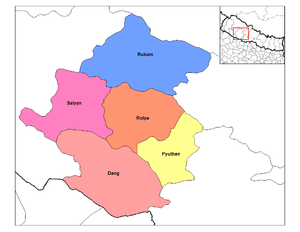
 Rolpa (red) | |
| Country | Nepal |
| Region | Mid-Western (grey) |
| Zone | Rapti (darker grey) |
| Headquarters | Libang |
| Population (2015[1]) | |
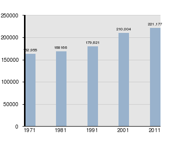
| • Total | 221,178 |
| Time zone | NPT (UTC+5:45) |
| Main language(s) | Nepali, Khamkura, Newari, English |
Coordinates: 28°22′N 082°33′E / 28.367°N 82.550°E
Rolpa(Nepali: रोल्पा जिल्ला![]() Listen , is a "hill" district some 280 km west of Kathmandu in Province No. 5 in midwestern Nepal. Rolpa covers an area of 1,879 km² with population (2011) of 221,177. Libang is the district's administrative center.
Listen , is a "hill" district some 280 km west of Kathmandu in Province No. 5 in midwestern Nepal. Rolpa covers an area of 1,879 km² with population (2011) of 221,177. Libang is the district's administrative center.
By Nepalese standards, Rolpa is an underdeveloped area plagued by low life expectancy (52 years) and poverty (averaging about $100 per capita). It was a major flashpoint in the 1996-2006 Civil War.
Adjoining districts are Dang to the south, Pyuthan to the east, Salyan to the west and Rukum to the north. Before the unification of Nepal by Prithvi Narayan Shah in 1769 Rolpa was a buffer between the Chaubisi confederation of small kingdoms to the east and the Baise confederation to the west.
Most of Rolpa is rugged highlands populated by the indigenous Kham Magar nationality. Irrigated ricefields along the Madi Khola are of limited extent because it has a narrow inner gorge. In any case the Kham Magar live about a thousand meters upslope where little rice can be grown. Upland harvests of maize, millet and barley are invariably insufficient and so Rolpa has chronic food deficits. As long as marijuana and charas (hashish) were legal in Nepal they were grown and processed in Rolpa and sent to Kathmandu to be sold in government monopoly stores. In 1976 the government gave in to international pressure and stopped buying these products, causing the district to lose an important source of cash income. Kham also make money by selling their labor. They work as agricultural laborers in other districts, as porters, as soldiers and as general laborers, but their input is devalued by Rolpa's underdeveloped education infrastructure. There is no post-secondary education in the district, and students who speak more Magar bhasha than Nepali are disadvantaged in primary and secondary education because Nepali is the medium of instruction and the national examination system selects against students who are not proficient in it. Without educational credentials Kham lack access to the more desirable jobs.
The various grievances of Rolpa's population made the district ripe for revolt. It became a "Maoist Stronghold" of the Communist Party of Nepal.[2] In May 2002 a major battle between Maoist guerillas and the army was fought at Lisne Lekh near the Rolpa-Pyuthan border.
Geography and Climate
Rolpa is drained southward by the Madi Khola from a complex of 3,000 to 4,000 meter ridges about 50 kilometers south of the Dhaulagiri Himalaya. This mountainous barrier historically isolated Rolpa by encouraging travelers between India and Tibet to detour to follow easier routes to the east or west, while east-west travelers found easier routes to the north through Dhorpatan Valley, or to the south through Dang Valley or along the Mahabharat Range.
| Climate Zone[3] | Elevation Range | % of Area |
|---|---|---|
| Upper Tropical | 300 to 1,000 meters 1,000 to 3,300 ft. |
3.3% |
| Subtropical | 1,000 to 2,000 meters 3,300 to 6,600 ft. |
61.7% |
| Temperate | 2,000 to 3,000 meters 6,400 to 9,800 ft. |
31.4% |
| Subalpine | 3,000 to 4,000 meters 9,800 to 13,100 ft. |
3.6% |
Population by Census 1971-2011[4][5]
Historic/Cultural/Archeological Sites
- Bhama Odar[6]
- Gari Lake, Jaulipokhari
- Bibang Daha, Gam
- Chaturbhuj Panchayan
- Baraha Khetra Badachaur
- Devi and Khadga Temple, Durga Bhawani, Durga Temple
- Gajulkot
- Jaljala, Jankot Jhankristhan
- Kalika Devi, Khungrikot, Kot Maula
- Pateswari Temple
- Shivalaya mandir
Village Development Committees (VDCs)
- Aresh
- Badachaur, Bhawang, Budhagaun
- Dhawang, Dubidanda, Dubring
- Eriwang
- Phagaam
- Gaam, Gajul, Gairigaun, Ghartigaun, Ghodagaun, Gumchal
- Harjang, Hwama
- Iriwang
- Jelbang, Jaimakasala, Jangkot, Jaulipokhari, Jedbang, Jhenam, Jinabang, Jungar
- Kareti, Khumel, Khungri, Korchabang, Kotgaun, Kureli
- Liwang
- Masina, Mijhing, Mirul
- Nuwagaun
- Pachhawang, Pakhapani, Pang
- Rangkot, Rangsi, Rank
- Sakhi, Seram, Sirpa, Siuri
- Talabang, Tebang, Thabang
- Uwa
- Wot
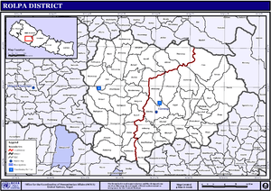
Maps
- From 1992 to 2002 a definitive series of large scale topographic maps were surveyed and published through a joint project by Government of Nepal Survey Department[7] and Finland's Ministry for Foreign Affairs contracting through the FinnMap consulting firm.[8] Japan International Cooperation Agency[9] substituted for FinnMap in Lumbini Zone.
References
- ↑ Statistics, Kathmandu, Nepal, Jan. 2014
- ↑ http://www.mercycorps.org/files/file1137793491.pdf
- ↑ The Map of Potential Vegetation of Nepal - a forestry/agroecological/biodiversity classification system (PDF), . Forest & Landscape Development and Environment Series 2-2005 and CFC-TIS Document Series No.110., 2005, ISBN 87-7903-210-9, retrieved Nov 22, 2013
- ↑
- "Districts of Nepal". Statoids. Gwillim Law. Retrieved January 23, 2014.
- ↑
- National Population and Housing Census 2011, Volume 3 (PDF). Kathmandu, Nepal: Government of Nepal, Central Bureau of Statistics. January 2014. Retrieved January 23, 2014.
- ↑ Budha Magar, Jaya Prakash, ed. (1997). Inventory of heritage sites in Nepal. Singapore: IUCN Nepal. Retrieved 11 November 2012.
- ↑ "Government of Nepal, Survey Department". Retrieved February 4, 2014.
- ↑ "Land Administration & Management, Mapping, Surveying and Aerial Photography, Major Reference Projects" (PDF). FinnMap. Retrieved February 4, 2014.
- ↑ "Japan International Cooperation Agency". Retrieved February 4, 2014.
- "Districts of Nepal". Statoids.
External links
| Wikimedia Commons has media related to Rolpa District. |