Rodeo Municipality
| Rodeo | |
|---|---|
| Municipality | |
 Municipality of Rodeo in Durango | |
|
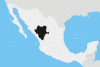
Rodeo Location in Mexico | |
| Coordinates: 25°11′N 104°34′W / 25.183°N 104.567°WCoordinates: 25°11′N 104°34′W / 25.183°N 104.567°W | |
| Country |
|
| State | Durango |
| Municipal seat | Rodeo |
| Area | |
| • Total | 1,854.9 km2 (716.2 sq mi) |
| Population (2010) | |
| • Total | 12,788 |
| • Density | 6.9/km2 (18/sq mi) |
Rodeo is one of the 39 municipalities of Durango, in north-western Mexico. The municipal seat lies at Rodeo. The municipality covers an area of 1,854.9 km².
As of 2010, the municipality had a total population of 12,788,[1] up from 11,231 as of 2005.[2]
As of 2010, the town of Rodeo had a population of 4,666.[1] Other than the town of Rodeo, the municipality had 71 localities, the largest of which (with 2010 population in parentheses) was: Abasolo (1,208), classified as rural.[1]
References
- 1 2 3 "Rodeo". Catálogo de Localidades. Secretaría de Desarrollo Social (SEDESOL). Retrieved 23 April 2014.
- ↑ "Rodeo". Enciclopedia de los Municipios de México. Instituto Nacional para el Federalismo y el Desarrollo Municipal. Retrieved November 18, 2008.
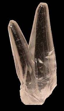
Twinned calcite crystals from Rodeo Municipio
This article is issued from Wikipedia - version of the 5/13/2014. The text is available under the Creative Commons Attribution/Share Alike but additional terms may apply for the media files.