Rockport, Maine
| Rockport, Maine | |
|---|---|
| Town | |
|
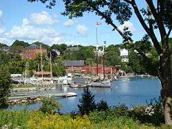
View of Rockport Harbor | |
 Location in Knox County and the state of Maine. | |
| Coordinates: 44°10′51″N 69°5′53″W / 44.18083°N 69.09806°W | |
| Country | United States |
| State | Maine |
| County | Knox |
| Incorporated | 1891 |
| Area[1] | |
| • Total | 33.34 sq mi (86.35 km2) |
| • Land | 21.64 sq mi (56.05 km2) |
| • Water | 11.70 sq mi (30.30 km2) |
| Elevation | 223 ft (68 m) |
| Population (2010)[2] | |
| • Total | 3,330 |
| • Estimate (2012[3]) | 3,317 |
| • Density | 153.9/sq mi (59.4/km2) |
| Time zone | Eastern (EST) (UTC-5) |
| • Summer (DST) | EDT (UTC-4) |
| ZIP code | 04856 |
| Area code(s) | 207 |
| FIPS code | 23-63660 |
| GNIS feature ID | 0582699 |
Rockport is a town in Knox County, Maine, United States. It is thirty-five miles southeast of Augusta. The population was 3,330 at the 2010 census. Rockport is a popular tourist destination and art colony.
History
Rockport, or "the River" was settled in 1769 by Robert Thorndike. Goose River Village (as it was known until 1852), was originally part of the Megunticook Plantation, incorporated in 1791 as Camden. Shipbuilding, ice harvesting and the manufacture of lime were important early industries.[4] In 1817, 300 casks of lime were sent to Washington, DC for use building the United States Capitol, which had been damaged by the British during the War of 1812. In 1852, the citizens of Goose River voted to change their village's name to Rockport for its rocky terrain.[5] On February 25, 1891, Rockport officially split from Camden because of a dispute over the cost of constructing a bridge. The town of Rockport was born and from Camden it took half the population, three quarters of the land, and most importantly the profitable lime and ice industries.
Rockport has a longstanding reputation as an artists' community, with notable artists and art institutions playing a significant role in the town's economic and social life. Bay Chamber Concerts was established in 1961 as a continuation of the summer music instruction of the Curtis Institute. Mary Louise Curtis Bok, central to founding both Bay Chamber Concerts and the Curtis Institute, was one of the largest landowners in Rockport. At one time she owned most of the eastern shore of the harbor. Mary Lea Park, adjacent to the Rockport Opera House, is named in honor of both her and Rockport resident and violinist Lea Luboshutz.[6]
Rockport was the home of Andre the Seal, a seal adopted by the Goodridge family in the 1961, and who was a significant tourist attraction in Rockport Harbor until his death in 1986. The seal's "owner" Harry Goodridge co-wrote a book about Andre, titled A Seal Called Andre. The 1994 film Andre was adapted from the book, although in the movie Andre is actually played by a sea lion, not a seal. A statue of Andre sits beside the harbor in his honor.[7] Rockport is also known for its Belted Galloway cattle. The cattle are raised at the 136-year-old Aldermere Farm, which is owned and operated by the Maine Coast Heritage Trust, a statewide land conservation organization. The Belted Galloways remain one of the area's most popular attractions, and often referred to as the "Oreo cookie" cows.[8]
The 1993 Warner Bros. film The Man Without a Face, starring Mel Gibson, Universal's 1995 film Casper and Miramax's 2001 film In the Bedroom were filmed in Rockport.
In 2008, Forbes magazine placed Rockport at the top of its list of the prettiest towns in America.[9]
Geography
According to the United States Census Bureau, the town has a total area of 33.34 square miles (86.35 km2), of which, 21.64 square miles (56.05 km2) of it is land and 11.70 square miles (30.30 km2) is water.[1] Drained by Varnah Brook and Goose River, Rockport is located beside Penobscot Bay and the Gulf of Maine, part of the Atlantic Ocean.
The town is crossed by U. S. Route 1 and state routes 17 and 90. It borders the towns of Rockland to the south, Warren to the southwest, Union to the west, Hope to the northwest, and Camden to the north.
Climate
This climatic region is typified by large seasonal temperature differences, with warm to hot (and often humid) summers and cold (sometimes severely cold) winters. According to the Köppen Climate Classification system, Rockport has a humid continental climate, abbreviated "Dfb" on climate maps.[10]
Demographics
| Historical population | |||
|---|---|---|---|
| Census | Pop. | %± | |
| 1900 | 2,314 | — | |
| 1910 | 2,022 | −12.6% | |
| 1920 | 1,774 | −12.3% | |
| 1930 | 1,651 | −6.9% | |
| 1940 | 1,526 | −7.6% | |
| 1950 | 1,656 | 8.5% | |
| 1960 | 1,893 | 14.3% | |
| 1970 | 2,067 | 9.2% | |
| 1980 | 2,749 | 33.0% | |
| 1990 | 2,854 | 3.8% | |
| 2000 | 3,209 | 12.4% | |
| 2010 | 3,330 | 3.8% | |
| Est. 2014 | 3,360 | [11] | 0.9% |
2010 census
As of the census[2] of 2010, there were 3,330 people, 1,422 households, and 967 families residing in the town. The population density was 153.9 inhabitants per square mile (59.4/km2). There were 1,956 housing units at an average density of 90.4 per square mile (34.9/km2). The racial makeup of the town was 97.6% White, 0.3% African American, 0.5% Native American, 0.4% Asian, and 1.2% from two or more races. Hispanic or Latino of any race were 1.1% of the population.
There were 1,422 households of which 27.7% had children under the age of 18 living with them, 56.1% were married couples living together, 8.7% had a female householder with no husband present, 3.2% had a male householder with no wife present, and 32.0% were non-families. 25.6% of all households were made up of individuals and 10.5% had someone living alone who was 65 years of age or older. The average household size was 2.34 and the average family size was 2.80.
The median age in the town was 48.8 years. 22% of residents were under the age of 18; 4.5% were between the ages of 18 and 24; 17.8% were from 25 to 44; 35.8% were from 45 to 64; and 19.9% were 65 years of age or older. The gender makeup of the town was 48.2% male and 51.8% female.
2000 census
In the 2000 census, there were 3,209 people, 1,373 households and 918 families in the town. The population density was 147.8 per square mile (57.1/km²). There were 1,677 housing units at an average density of 77.2 per square mile (29.8/km²). The racial makeup was 98.69% White, 0.16% African American, 0.06% Native American, 0.44% Asian, 0.19% from other races, and 0.47% from two or more races. Hispanic or Latino of any race were 0.75% of the population.
There were 1,373 households, of which 29.6% had children under 18 living with them, 56.2% were married couples living together, 8.2% had a female householder with no husband present, and 33.1% were non-families. 27.7% of all households were made up of individuals and 11.5% had someone living alone who was 65 years of age or older. The average household size was 2.33 and the average family size was 2.83.
In the town the population was spread out with 23.5% under 18, 5.0% from 18 to 24, 25.3% from 25 to 44, 28.9% from 45 to 64, and 17.3% who were 65 or older. The median age was 43. For every 100 females there were 91.7 males. For every 100 females 18 and over, there were 89.0 males.
The median income for a household in the town was $47,155, and the median for a family $56,068. Males had a median of $35,865 versus $25,542 for females. The per capita income for the town was $25,498. About 5.4% of families and 7.1% of the population were below the poverty line, including 10.2% of those under 18 and 7.3% of those 65 or over.
Gallery
 Tidal Island
 View of the harbor
 McCobb Spite House
Sites of interest
- Aldermere Farm—Maine Coast Heritage Trust[13]
- Bay Chamber Concerts
- Camden Area History Center[14]
- Camden-Rockport Historical Society[15]
- Center for Maine Contemporary Art[16]
- Indian Island Light[17]
- Maine Media Workshops
- Rockport Opera House[18]
Education
- Maine School Administrative District 28 operates K-8 schools
- Camden Hills Regional High School[19]
Notable People
- Stephen Bowen, state legislator and Commissioner of Education under Paul LePage
- Lew Dietz, writer
- T. Allen Lawson, artist
References
- 1 2 "US Gazetteer files 2010". United States Census Bureau. Retrieved 2012-12-16.
- 1 2 "American FactFinder". United States Census Bureau. Retrieved 2012-12-16.
- ↑ "Population Estimates". United States Census Bureau. Retrieved 2013-07-06.
- ↑ Maine League of Historical Societies and Museums (1970). Doris A. Isaacson, ed. Maine: A Guide 'Down East'. Rockland, Me: Courier-Gazette, Inc. pp. 264–265.
- ↑ Varney, George J. (1886), Gazetteer of the state of Maine. Camden (and Rockport), Boston: Russell
- ↑ A History of Bay Chamber Concerts
- ↑ Marine Life Series: Andre the Harbor Seal
- ↑ Aldermere Farm History
- ↑ Forbes: "America's Prettiest Towns"
- ↑ Climate Summary for Rockport, Maine
- ↑ "Annual Estimates of the Resident Population for Incorporated Places: April 1, 2010 to July 1, 2014". Retrieved June 4, 2015.
- ↑ "Census of Population and Housing". Census.gov. Retrieved June 4, 2015.
- ↑ Aldermere Farm -- Maine Coast Heritage Trust
- ↑ Camden Area History Center
- ↑ Camden-Rockport Historical Society
- ↑ Center for Maine Contemporary Art
- ↑ Indian Island Light
- ↑ Rockport Opera House
- ↑ Camden Hills Regional High School
External links
- Town of Rockport, Maine
- Rockport Public Library
- Chamber of Commerce
- Samoset Resort
- History of The Samoset Hotel
- Maine Genealogy: Rockport, Knox County, Maine
Coordinates: 44°11′04″N 69°04′34″W / 44.18444°N 69.07611°W
Municipalities and communities of Knox County, Maine, United States | ||
|---|---|---|
| City |  | |
| Towns | ||
| Plantation | ||
| Unorganized territory | ||
| CDPs | ||
| Other villages | ||