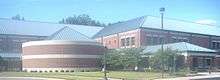
Rochester Hills, Michigan
| Rochester Hills, Michigan | |
|---|---|
| City | |
 | |
| Coordinates: 42°39′57″N 83°9′29″W / 42.66583°N 83.15806°W | |
| Country | United States |
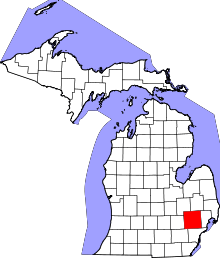
| State | Michigan |
| County | Oakland |
| Incorporated | 1984 |
| Government | |
| • Type | Council-Strong Mayor |
| • Mayor | Bryan K. Barnett |
| Area[1] | |
| • Total | 32.91 sq mi (85.24 km2) |
| • Land | 32.82 sq mi (85.00 km2) |
| • Water | 0.09 sq mi (0.23 km2) 0.27% |
| Elevation | 820 ft (250 m) |
| Population (2015)[2] | |
| • Total | 70,995 |
| • Estimate (2015[3]) | 72,283 |
| • Density | 2,163.2/sq mi (835.2/km2) |
| Time zone | Eastern (EST) (UTC-5) |
| • Summer (DST) | EDT (UTC-4) |
| ZIP codes | 48306, 48307, 48309 |
| Area code(s) | 248, 947 |
| FIPS code | 26-69035[4] |
| GNIS feature ID | 1675440[5] |
| Website | http://www.rochesterhills.org/ |
Rochester Hills is a city in northeast Oakland County of the U.S. state of Michigan, in the northern outskirts of Metropolitan Detroit area. As of the 2010 census, the city had a total population of 70,995.[6] The main branch of the Rouge River rises in Rochester Hills in Oakland County.
Communities
- Stoney Creek is a non-census designated village on the northeast end of the city on the border with Rochester.
- Yates is on the boundary with Rochester and Shelby Township, Oakland County (42°40′25″N 83°05′45″W / 42.67361°N 83.09583°W ; Elevation: 669 ft./204 m.).[7]
History
Prior to European settlement, the area now known as Rochester Hills was inhabited by Native Americans, namely the Potawatomi.[8] The Potawatomi depended on the area's abundant water sources, such as the Clinton River and Paint Creek, to grow crops, fish, and travel.[8][9] They resided here until the 1807 Treaty of Detroit caused them, along with the Odawa, Wyandot, and Ojibwe peoples, to cede their land in Southeast Michigan.[10][11]
The first European settler was James Graham who arrived in 1817. Graham and his family reached the area by following trails created by the Sauk Native Americans. [12][13]Avon Township was organized in 1835. Rochester incorporated as a village within the township in 1869. The township adopted a charter in 1948 under the Home Rule Act. Also in 1948 a post office was established under the name of Brooklands for the area between Auburn Road and Hamlin Road just to the west of Dequindre Road.[14]
In 1966, village residents voted to become the City of Rochester, effective in February 1967. As a result, Rochester residents no longer had to pay property taxes to the township, as it was now a separate municipality.
In 1967, Avon Township filed a petition to become a city. In January 1968, township voters approved the petition to move forward with seeking city status. Three proposed city charters were voted down by residents, the first in March 1969, the second in May 1970, and the third in September 1971. The city of Rochester then sought to annex all of the township, which was unanimously denied by the Michigan Boundary Commission. In 1972, petitions were filed to consolidate Avon Township and Rochester. In April 1974, the consolidation petition lost by 350 votes in the township, while passing by four votes in Rochester. In May 1974, Rochester's petition to annex 2.2 square miles (5.7 km2) of Avon Township was approved by the Michigan Boundary Commission. The township became Avon Charter Township in August 1978. Court challenges to the 1974 annexation continued until November 1981, when the township was ordered to surrender the annexed property.
In May 1984, township voters approved a city charter. On November 20, 1984, Avon Township became the City of Rochester Hills. The name of the new city was put to a vote, with the other choice being "Avon Hills". The name "Rochester Hills" won by a landslide with voters, based on the area's historical ties to Rochester and the rolling hills that abound in the area. Township Supervisor Earl E. Borden became Rochester Hills' first mayor.
Geography
Rochester Hills is bordered to the north by Oakland Charter Township, to the south by the city of Troy, to the east by Shelby Township in Macomb County, and to the west by the city of Auburn Hills. Rochester Hills is also partially bordered by the city of Rochester to the east. According to the United States Census Bureau, the city has a total area of 32.91 square miles (85.24 km2), of which 32.82 square miles (85.00 km2) is land and 0.09 square miles (0.23 km2) is water.[1] Elevations in the city range from 690 feet (210 m) above sea level in the southeastern portion of the city to 1,010 feet (310 m) in the northwestern section.
 |
Orion Township | Oakland Township | Washington Township | |
| Auburn Hills | |
Rochester Shelby Township | ||
| ||||
| | ||||
| Bloomfield Township | Troy | Sterling Heights |
Demographics
| Historical population | |||
|---|---|---|---|
| Census | Pop. | %± | |
| 1990 | 61,766 | — | |
| 2000 | 68,825 | 11.4% | |
| 2010 | 70,995 | 3.2% | |
| Est. 2015 | 73,424 | [15] | 3.4% |
2010 census
As of the census[2] of 2010, there were 70,995 people, 27,578 households, and 19,308 families residing in the city. The population density was 2,163.2 inhabitants per square mile (835.2/km2). There were 29,494 housing units at an average density of 898.7 per square mile (347.0/km2). The racial makeup of the city was 89.1% White, 2.5% African American, 0.2% Native American, 4.5% Asian, 0.7% from other races, and 1.9% from two or more races. Hispanic or Latino of any race were 1.1% of the population.
There were 27,578 households of which 33.2% had children under the age of 18 living with them, 59.2% were married couples living together, 8.1% had a female householder with no husband present, 2.8% had a male householder with no wife present, and 30.0% were non-families. 25.7% of all households were made up of individuals and 10.3% had someone living alone who was 65 years of age or older. The average household size was 2.53 and the average family size was 3.08.
The median age in the city was 40.9 years. 23.7% of residents were under the age of 18; 7.7% were between the ages of 18 and 24; 24.6% were from 25 to 44; 30.3% were from 45 to 64; and 13.8% were 65 years of age or older. The gender makeup of the city was 48.4% male and 51.6% female.
Between 2000 and 2010, the Asian population in Rochester Hills increased to almost 10% of the community's population, a 61% increase from the 2000 figure.[17]
Government
Rochester Hills has a Mayor-council government. The Rochester Hills City Council consists of seven Council Members: four district members and three at-large members. They are elected to four-year terms and, due to term limiting, can serve no more than two terms for a maximum of eight years.
Education
The Rochester Community Schools serves most of the city. Rochester Adams High School, Rochester High School, and Stoney Creek High School are in Rochester Hills.
Some portions of the city are in the Avondale School District. Much of the ASD portion of Rochester Hills is zoned to Deerfield Elementary School, within the city. Other portions are zoned to Auburn Elementary School in Auburn Hills and Woodland Elementary School in Troy. All ASD residents are zoned to Avondale Middle School in Rochester Hills and Avondale High School in Auburn Hills. The Meadows School, Avondale Academy, and the ASD transportation department are all in Rochester Hills.[18]
The city provides the Rochester Hills Public Library which is located in Rochester (The City of Rochester and Oakland Township contract with the City of Rochester Hills for residents' use of the library).
The Japanese School of Detroit, a supplementary school for Japanese citizens of school age, at one time had its administrative offices in the former Oakland Steiner School in Rochester Hills.[19]
Notable people
This list includes people from the Rochester area (Rochester, Rochester Hills, and Oakland Township) (48306, 48307, 48309, 48363):
- Andrew Good Major League baseball player grew up in Rochester Hills graduated from Rochester High
- Madonna, singer and actress; grew up in Rochester Hills, graduated from Rochester Adams High School[20]
- Tommy Clufetos, drummer for Ozzy Osbourne, Alice Cooper, and Ted Nugent; graduated from Rochester Adams High School
- Paul Davis, professional basketball player; graduated from Rochester High School
- Hal Foster, artist and writer; lived in Rochester for a period during his work of the comic strip Prince Valiant
- Amy Frazier, professional tennis player; graduated from Rochester Adams High School
- Jay Gibbons, professional baseball player[21]
- Shawn Hare, professional baseball player; attended Rochester Community Schools
- Greg and Tim Hildebrandt, fantasy artists and painters of the original Star Wars movie poster
- Rude Jude, television and radio personality; graduated from Rochester High School
- George Jamison, former NFL player for the Detroit Lions
- Bob Keselowski, NASCAR driver
- Brad Keselowski, NASCAR driver
- Walt Kowalczyk, professional American football player
- Jana Kramer, country music singer and actress
- Idris Goodwin, playwright, poet, activist, professor at Colorado College
- Alec Martinez, professional hockey player
- Marshall Bruce Mathers III (aka Eminem), rapper, actor and producer; currently lives in Oakland Township
- Craig Owens, lead singer of Chiodos and Cinematic Sunrise
- Roxy Petrucci, drummer of all-female rock/metal band Vixen in the 1980s
- Brian Sell, retired marathoner; resides in Rochester Hills
- Joey Sturgis, record producer; resides in Rochester
- Ron Teachworth, educator, artist, writer and filmmaker
- Jacob Trouba, NHL hockey player for the Winnipeg Jets
- Peter Vanderkaay, Olympic gold medalist in swimming; graduated from Rochester Adams High School in 2002
- Jason Varitek, professional baseball player; born in Rochester
- Dita Von Teese, burlesque artist, model and actress
- Robert Simpson Woodward, physicist and mathematician; born in Rochester
- Aileen Wuornos, serial killer; born in Rochester
References
Notes
- 1 2 "US Gazetteer files 2010". United States Census Bureau. Retrieved 2012-11-25.
- 1 2 "American FactFinder". United States Census Bureau. Retrieved 2012-11-25.
- ↑ "Population Estimates". United States Census Bureau. Retrieved 2013-06-03.
- ↑ "American FactFinder". United States Census Bureau. Retrieved 2008-01-31.
- ↑ U.S. Geological Survey Geographic Names Information System: Rochester Hills, Michigan
- ↑ "Race, Hispanic or Latino, Age, and Housing Occupancy: 2010 Census Redistricting Data (Public Law 94-171) Summary File (QT-PL), Rochester Hills city, Michigan". U.S. Census Bureau, American FactFinder 2. Retrieved August 19, 2011.
- ↑ U.S. Geological Survey Geographic Names Information System: Yates, Michigan & GNIS in Google Map
- 1 2 "Native Americans of the Clinton River Watershed". Clinton River Watershed Council. Clinton River Watershed Council. Retrieved 23 November 2016.
- ↑ De Vaudreuil, M. "General Memoir Respecting the Indians between Lake Erie and the Mississippi, with Remarks upon Their Territory, Manners, Habits, Etc." In Documents Relative to the Colonial History of the State of New York, edited by E. B. O'Callaghan, MD, compiled by John Romeyn Brodhead, Esq, 887-90. Vol. IX. Albany, NY: Weed, Parsons and Company Printers, 1855.
- ↑ Duval, Roger. "Potawatomi Native Americans Fish and Hunt at Bald Eagle Lake". History of Bald Eagle Lake. Bald Eagle Lake Property Owner's Association. Retrieved 26 November 2016.
- ↑ Hull, William. "Treaty with the Ottawa, Etc., 1807". Indian Affairs: Laws and treaties. Oklahoma State University. Retrieved 25 November 2016.
- ↑ "Our Community's History." Rochester Hills, MI Official Website. https://www.rochesterhills.org/index.aspx?NID=267.
- ↑ "Saginaw Trail Historic Marker." Detroit: The History and Future of the Motor City. July 2009. http://www.detroit1701.org/.
- ↑ Romig 1986, p. 80.
- ↑ "Annual Estimates of the Resident Population for Incorporated Places: April 1, 2010 to July 1, 2015". Retrieved July 2, 2016.
- ↑ "Census of Population and Housing". Census.gov. Retrieved June 4, 2015.
- ↑ Steele, Micki. "Asian-Americans settle in Metro Detroit enclaves." The Detroit News. April 19, 2011. Retrieved on September 9, 2013.
- ↑ "District Map" (Archive). Avondale School District. Retrieved on June 20, 2015.
- ↑ "JSD History" (Archive). Japanese School of Detroit. May 2, 2001. Retrieved on April 16, 2015. "(1999) 事務局移転(インターナショナル・アカデミー校→旧オークランド・シュタイナー校) "
- ↑ "Singer of the Week: Madonna". AskMen.com. IGN Entertainment, Inc. Archived from the original on 13 June 2006. Retrieved 2006-06-01.
- ↑ "Jay Gibbons Stats". Baseball Almanac. Retrieved November 21, 2012.
Sources
- Romig, Walter (October 1, 1986) [1973]. Michigan Place Names: The History of the Founding and the Naming of More Than Five Thousand Past and Present Michigan Communities. Great Lakes Books Series (Paperback). Detroit, Michigan: Wayne State University Press. ISBN 0-8143-1838-X. ISBN 978-0814318386.
External links
| Topics |  | |
|---|---|---|
| Detroit | ||
| Municipalities over 80,000 | ||
| Municipalities 40,000 to 80,000 | ||
| Cultural enclaves | ||
| Satellite cities | ||
| Counties in MSA | ||
| Counties in CSA | ||
Coordinates: 42°39′29″N 83°8′59″W / 42.65806°N 83.14972°W