Robinson, Kansas
| Robinson, Kansas | |
|---|---|
| City | |
|
Aerial view of Robinson (2013) | |
 Location within Brown County and Kansas | |
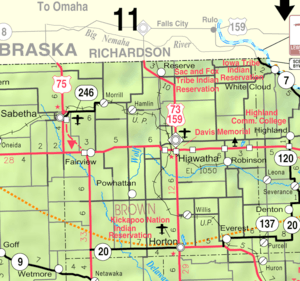 KDOT map of Brown County (legend) | |
| Coordinates: 39°48′59″N 95°24′38″W / 39.81639°N 95.41056°WCoordinates: 39°48′59″N 95°24′38″W / 39.81639°N 95.41056°W | |
| Country | United States |
| State | Kansas |
| County | Brown |
| Area[1] | |
| • Total | 0.24 sq mi (0.62 km2) |
| • Land | 0.24 sq mi (0.62 km2) |
| • Water | 0 sq mi (0 km2) |
| Elevation | 955 ft (291 m) |
| Population (2010)[2] | |
| • Total | 234 |
| • Estimate (2012[3]) | 232 |
| • Density | 980/sq mi (380/km2) |
| Time zone | Central (CST) (UTC-6) |
| • Summer (DST) | CDT (UTC-5) |
| ZIP code | 66532 |
| Area code(s) | 785 |
| FIPS code | 20-60325 [4] |
| GNIS feature ID | 0472996 [5] |
| Website | City Website |

Robinson is a city in Brown County, Kansas, United States. As of the 2010 census, the city population was 234.[6]
History
Robinson had its start in the year 1871 by the building of the railroad through that territory.[7][8] It was named to honor the first governor of the State of Kansas, Charles Robinson.[9] It had formerly been known locally as Lickskillet derived from the practice of an old trapper who allegedly put his dirty dishes out for his dog to lick clean.[10]
Geography
Robinson is located at 39°48′59″N 95°24′38″W / 39.81639°N 95.41056°W (39.816256, -95.410567),[11] along the Wolf River.[12] According to the United States Census Bureau, the city has a total area of 0.24 square miles (0.62 km2), all of it land.[1]
Demographics
| Historical population | |||
|---|---|---|---|
| Census | Pop. | %± | |
| 1880 | 210 | — | |
| 1900 | 493 | — | |
| 1910 | 492 | −0.2% | |
| 1920 | 500 | 1.6% | |
| 1930 | 457 | −8.6% | |
| 1940 | 413 | −9.6% | |
| 1950 | 381 | −7.7% | |
| 1960 | 317 | −16.8% | |
| 1970 | 278 | −12.3% | |
| 1980 | 324 | 16.5% | |
| 1990 | 268 | −17.3% | |
| 2000 | 216 | −19.4% | |
| 2010 | 234 | 8.3% | |
| Est. 2015 | 231 | [13] | −1.3% |
| U.S. Decennial Census | |||
2010 census
As of the census[2] of 2010, there were 234 people, 92 households, and 64 families residing in the city. The population density was 975.0 inhabitants per square mile (376.4/km2). There were 109 housing units at an average density of 454.2 per square mile (175.4/km2). The racial makeup of the city was 92.7% White, 0.4% from other races, and 6.8% from two or more races. Hispanic or Latino of any race were 1.3% of the population.
There were 92 households of which 37.0% had children under the age of 18 living with them, 56.5% were married couples living together, 8.7% had a female householder with no husband present, 4.3% had a male householder with no wife present, and 30.4% were non-families. 23.9% of all households were made up of individuals and 14.1% had someone living alone who was 65 years of age or older. The average household size was 2.54 and the average family size was 2.97.
The median age in the city was 42.5 years. 26.1% of residents were under the age of 18; 6.4% were between the ages of 18 and 24; 20.1% were from 25 to 44; 31.7% were from 45 to 64; and 15.8% were 65 years of age or older. The gender makeup of the city was 50.4% male and 49.6% female.
2000 census
As of the census[4] of 2000, there were 216 people, 94 households, and 62 families residing in the city. The population density was 887.0 people per square mile (347.5/km²). There were 111 housing units at an average density of 455.8 per square mile (178.6/km²). The racial makeup of the city was 93.98% White, 0.46% Native American, 0.46% Asian, 1.85% from other races, and 3.24% from two or more races. Hispanic or Latino of any race were 1.85% of the population.
There were 94 households out of which 30.9% had children under the age of 18 living with them, 55.3% were married couples living together, 7.4% had a female householder with no husband present, and 33.0% were non-families. 29.8% of all households were made up of individuals and 20.2% had someone living alone who was 65 years of age or older. The average household size was 2.30 and the average family size was 2.81.
In the city the population was spread out with 24.1% under the age of 18, 6.0% from 18 to 24, 21.8% from 25 to 44, 26.4% from 45 to 64, and 21.8% who were 65 years of age or older. The median age was 44 years. For every 100 females there were 116.0 males. For every 100 females age 18 and over, there were 97.6 males.
The median income for a household in the city was $20,938, and the median income for a family was $24,375. Males had a median income of $30,208 versus $16,364 for females. The per capita income for the city was $13,203. About 13.8% of families and 22.3% of the population were below the poverty line, including 39.1% of those under the age of eighteen and 22.2% of those sixty five or over.
Notable people
- James Breeding, U.S. Representative from Kansas.
- Martin Trapp, sixth governor of Oklahoma.
References
- 1 2 "US Gazetteer files 2010". United States Census Bureau. Retrieved 2012-07-06.
- 1 2 "American FactFinder". United States Census Bureau. Retrieved 2012-07-06.
- ↑ "Population Estimates". United States Census Bureau. Retrieved 2013-05-29.
- 1 2 "American FactFinder". United States Census Bureau. Retrieved 2008-01-31.
- ↑ "US Board on Geographic Names". United States Geological Survey. 2007-10-25. Retrieved 2008-01-31.
- ↑ "2010 City Population and Housing Occupancy Status". U.S. Census Bureau. Retrieved April 9, 2012.
- ↑ Kansas State Historical Society (1916). Biennial Report of the Board of Directors of the Kansas State Historical Society. Kansas State Printing Plant. p. 150.
- ↑ Blackmar, Frank Wilson (1912). Kansas: A Cyclopedia of State History, Volume 2. Standard Publishing Company. p. 589.
- ↑ Capace, Nancy (1 June 2000). Encyclopedia of Kansas. North American Book Dist LLC. p. 259. ISBN 978-0-403-09312-0.
- ↑ Kansas Place-Names, John Rydjord, University of Oklahoma Press, 1972, p. 327 ISBN 0-8061-0994-7
- ↑ "US Gazetteer files: 2010, 2000, and 1990". United States Census Bureau. 2011-02-12. Retrieved 2011-04-23.
- ↑ DeLorme (2003). Kansas Atlas & Gazetteer. p. 26. Yarmouth, Maine: DeLorme. ISBN 0-89933-342-7.
- ↑ "Annual Estimates of the Resident Population for Incorporated Places: April 1, 2010 to July 1, 2015". Retrieved July 2, 2016.
External links
| Wikimedia Commons has media related to Robinson, Kansas. |
- City
- Schools
- USD 415, local school district
- Maps
- Robinson City Map, KDOT
Municipalities and communities of Brown County, Kansas, United States | ||
|---|---|---|
| Cities | 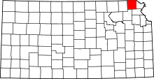 | |
| CDPs | ||
| Unincorporated communities | ||
| Indian reservations | ||
| Townships | ||
| Footnotes | ‡This populated place also has portions in an adjacent county or counties | |