Roads in Ireland
.png)
(OpenStreetMap mapping)
The island of Ireland, comprising Northern Ireland and the Republic of Ireland, has an extensive network of tens of thousands of kilometres of public roads, usually surfaced. These roads have been developed and modernised over centuries, from trackways suitable only for walkers and horses, to surfaced roads including modern motorways. Northern Ireland has had motorways since 1962, and has a well-developed network of primary, secondary and local routes. Historically, the road network in the Republic of Ireland was less well developed and maintained. However, with the advent of the Celtic Tiger and significant European Union funding, most national roads in the Republic continue to be upgraded. In the 1990s the Republic went from having only a few short sections of motorway to constructing motorways, dual-carriageways and other improvements on most major routes as part of a National Development Plan. Road construction in Northern Ireland has proceeded at a slower pace in recent years, although a number of important bypasses and upgrades to dual carriageway have recently been completed or are about to begin.
Roads in Northern Ireland are classified as either Highways, motorways (shown by the letter M followed by a route number, e.g. M1), A-roads (shown by the letter A followed by a route number, e.g. A6), B-roads (shown by the letter B followed by a route number, e.g. B135) and other roads. There are two types of A-roads: primary and non-primary.
Roads in the Republic are classified as either motorways (shown by the letter M followed by a route number, e.g. M7), National roads (shown by the letter N followed by a route number, e.g. N25), Regional roads (shown by the letter R followed by a route number, e.g. R611) and Local roads (shown by the letter L followed by a route number, e.g. L4202). There are two types of National roads: National Primary routes and National Secondary routes.
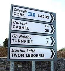
Distance signposts in Northern Ireland show distances in miles, while all signposts placed in the Republic since the 1990s use kilometres. The Republic's road signs are bilingual, using both official languages, Irish and English. The Irish names are written in lower case italic script. Signs in Northern Ireland are in English only. Warning signs in the Republic have a yellow background and are diamond-shaped, those in Northern Ireland are triangle-shaped and have a white background with a red border.
Speed limits in Northern Ireland are specified in miles per hour. Those in the Republic use kilometres per hour (km/h or kph), a change introduced on 20 January 2005.[1] This involved the provision of 58,000 new metric speed limit signs, replacing and supplementing 35,000 imperial signs.
History
There have been routes and trackways in Ireland connecting settlements and facilitating trade since ancient times. Ireland was never part of the Roman Empire and, therefore, Roman roads were not built in Ireland. However, an Iron Age road with a stone surface has been excavated in Munster[2] and togher (Irish: tóchar) roads, a type of causeway built through bogs, were found in many areas of the country.[3]
According to an entry[4] in the Annals of the Four Masters for AD 123, there were five principal highways (Irish: slighe) leading to Tara (Irish: Teamhair) in Early Medieval Ireland.
Early medieval law-tracts[5] set out five types of road including the highway (slighe), the '[regional] main road' (ród or rout), the 'connecting road' (lámraite), the 'side road' (tógraite) which could be tolled, and the 'cow road' (bóthar). Bóthar is the most common term for 'road' in modern Irish: its diminutive form, bóithrín, (or boreen in English) is used as a term for very narrow, rural roads.
The development of roads in Ireland seemed to have stagnated until the eighteenth- and early nineteenth-centuries. However, in the 18th century, a network of turnpike roads (charging tolls) was built: "a turnpike was a primitive form of turnstile – a gate across the road, opened on payment of a toll. The average length of a turnpike road was 30 miles". Routes to and from Dublin were developed initially and the network spread throughout the country. Turnpikes operated between 1729 and 1858 when the extensive railway network made them increasingly unpopular.[6]
Specialist routes to facilitate the butter trade, which centred on Cork, were built in Munster. The first butter road was commissioned in 1748 and was built by John Murphy of Castleisland in County Kerry.[7] In other areas, notably in County Wicklow, military roads were built to help secure British military control over remote areas. The Military Road through County Wicklow was begun in 1800 and completed in 1809.[8] The R115 is part of the Military Road for its entire length.
Railways became the dominant form of land transport from the mid-19th century. This situation persisted until the first half of the 20th century when motorised road transport (cars, buses and trucks) gradually began to take over from railways as the most important form of land transport.
Pre-independence legislation (the Ministry of Transport Act, 1919[9]) laid the foundation for the regulation of the modern system of public roads in Ireland. The Act gave the Minister for Local Government the power to classify roads: Trunk Road Funds were used to enable local councils to improve major roads and road surfacing was gradually undertaken throughout the 1920s, 1930s and beyond.
By the 1950s an established system of road classification and numbering with Trunk Roads and Link Roads had long been developed. The present system of road classification and numbering began in 1977 when twenty-five National primary roads and thirty-three National secondary roads were designated.
Regional roads were first formally designated in 1994, although Regional road route-numbers began appearing on signposts in the 1980s. The Roads Act 1993 also classified all public roads which are not national or regional roads as local roads.
Roads in the Republic of Ireland

County Laois.
The Republic has an extensive network of public roads connecting all parts of the country. As of 31 December 2007, there was a total of 5,427.58 km of national roads: 2,743.606 km of national primary routes (including motorways) and 2,683.974 km of national secondary routes.[10] In addition to national roads, the Republic also has an extensive network of other public roads: there are 11,630 kilometres of regional roads and 78,972 kilometres of local roads.
The Republic's major road network is focused on Dublin. Motorways were extended from Dublin to other major cities as part of the Transport 21 programme which aimed to have a world-class motorway network in place by the end of 2010. By the end of 2010, Ireland's main cities (Cork, Limerick, Galway, Waterford and Belfast) excluding Derry were connected to Dublin with motorways or with near-motorway standard roads. Dublin has been the focus of some other major projects, such as the East-Link and West-Link toll-bridges, as well as the Dublin Port Tunnel. Major by-pass projects are underway at other cities and towns; most of these are under construction as of 2009. The Jack Lynch Tunnel under the River Lee in Cork was a major project outside Dublin, and a fourth crossing at Limerick under the River Shannon (known as the Limerick Tunnel) opened in 2010.
The different classes of roads in Ireland are allocated blocks of numbers so that no number is used more than once.(not all road numbers are currently in use):
- National Primary Roads are numbered from N1 to N50 (motorway sections are signed with M prefix instead of N ).
- National Secondary Roads are numbered from N51 to N99.
- Regional Roads are numbered from R100 to R999.
- Local Primary Roads are numbered from L1000 to L4999.
- Local Secondary Roads are numbered from L5000 to L8999.
- Local Tertiary Roads are numbered from L10001 to L89999 with the first 4 digits representing the Local Primary or Secondary road it is off. Local Tertiary roads which are unrelated to a Local Primary or Secondary road are given numbers from L90000 up.
Motorways
In the Republic of Ireland, a motorway forms part of a national primary route, but is indicated by the prefix M instead of N. Motorways are the highest standard roads are certain drivers and vehicles are prohibited from using them. The motorway network has been expanded extensively since the 1990s, through construction of new motorways and redesignation of existing motorway-standard dual-carriageway sections of National Primary routes.
The first motorway section in the state was the M7 Naas by-pass, which opened in 1983. As of 2009, all motorways in Ireland are part of, or form, national primary roads. At the end of 2004 there were 192 km (119 mi) of motorway in the Republic and 286 km (178 mi) of dual-carriageway.[11] This was extended, by the end of 2005, to 247 km (153 mi) of motorway and 297 km (185 mi) of dual-carriageway.[12] By the end of December 2009 there were 667 km (414 mi) of motorway in Ireland, with 385 kilometres (239 mi) under construction.[13]
As of 2012, the following motorway routes are in operation:
- M1, part of the Dublin – Belfast route: from M50 J3 at Dublin Airport to Thistle Cross (just north of Dundalk) where it reverts to the N1 dual carriageway up to the border with Northern Ireland (where it continues without interruption as the A1 to Belfast).
- M2, part of the Dublin – Derry route: from just north of M50 J5 to just north of Ashbourne, County Meath, where it reverts to the N2.
- M3, part of the Dublin – Cavan/Enniskillen route: from Clonee (on N3 from M50 J6) to Kells bypass.
- M4, part of the Dublin – Sligo route: from Lucan (on N4 from M50 J7) to Kinnegad at which point it reverts to dual carriageway to (bypass) Mullingar.
- M6, part of the Dublin – Galway route: leaves M4 at J11 near Kinnegad, ending at the N18 crossing where it reverts to the N6 dual carriageway around Galway. The section around Athlone reverts to N6 status as it is an all-traffic dual carriageway. This was the first city-to-city motorway link in Ireland. Opened Jan 2010.
- M7, part of the Dublin – Limerick route: begins at the Naas bypass at the end of the N7 Naas Road dual carriageway from M50 J9 and continues to Rossbrien outside Limerick where the motorway forms an interchange with the N18 & M20 routes at junction 30.
- M8, part of the Dublin – Cork route: branches off the M7 at junction 19 and continues to the Dunkettle interchange outside Cork where it forms an interchange with the N25 and N40 routes.
- M9, part of the Dublin – Waterford route: branches off the M7 at junction 11 and continues towards the Quarry Roundabout outside Waterford where it forms a junction with the N24.
- M11, three separate parts of the Dublin – Wexford route: the southern tip of the M50 to the west side of Bray, the Ashford/Rathnew Bypass and the Arklow/Gorey Bypass.
- M18, part of the Limerick – Galway route: begins at junction 9 for Shannon Airport from the N18 dual carriageway from the Rossbrien Interchange in Limerick and continues to junction 16 for Gort. From here the route reverts to single carriageway to Claregalway with a junction on the M6 for Galway.
- M20, part of the Limerick – Cork route: branches off the M7 at junction 30 and the N18 at junction 1 at the Rossbrien interchange outside Limerick and continues for 10 km towards Attyflin near Patrickswell at junction 4. Here the route forms an interchange with the N20 towards Cork and the N21 to Tralee & Killarney. Both the N20 & N21 from here are single carriageway.
- M50, 45 km C – shaped ring road that forms a bypass of Dublin. The motorway connects to all the national primary routes from Dublin to the main cities and regions of Ireland as well as Dublin City centre.
In June 2007, it was announced that around 800 kilometres of 'new' motorway would be created; however, much of this resulted from the re-classification of most of the country's high-quality dual carriageways to motorway regulations rather than the construction of purpose-built motorways. This has affected most of the major inter-urban routes between Dublin and various towns and cities and some of the Atlantic Corridor along the Western seaboard.[14]
Planned Motorways
- M17; In December 2007, it was announced that a planned high quality dual carriageway scheme between Galway and Tuam would be built as a motorway, the first such new motorway project to be announced since the early 2000s.[15][16]
- M18; from Gort to Galway completing the upgrade of the Limerick to Galway route. On 30 September 2008 (see below), it was announced that the proposed 26.6 km Gort to Oranmore scheme was to be included in the second tranche of motorway re-designations as it will link into the proposed M17.
- M20; Completion of the upgrading of the N20 route between Cork and Limerick to motorway standard.[17] This will extend the existing section of M20 outside Limerick to Cork.
By 2015, the NRA planned that there would be approximately 1090 km of motorway in Ireland, comprising the M50 (49 km), M20 (90 km approx), M18 (70 km approx), M17 (25.5 km), M11 (62 km), M9 (116.5 km), M8 (143 km), M7 (185 km), M6 (144 km), M4 (62 km), M3 (57 km), M2 (13 km), and M1 (83 km). However the Irish financial crisis has brought this target into question.
National primary roads
National Primary routes form the main cross country roads in Ireland and include all motorways. This category of road is numbered from 1–50 with the prefix "N" (or "M" for motorway sections). The routes numbered N1-N11 radiate anti-clockwise from Dublin, with those in the range N12-N26 being cross-country roads and N27-N33 being newer short link roads. The N40 is the Cork Ring Road and the N50 is the Dublin Ring Road. National secondary roads (see next section) are numbered under the same scheme with higher numbers. On road signage, destinations served but not on the route in question are listed in brackets, with the connecting route also listed (see thumbnail).
Northern Ireland route sections (which are classified separately according to NI schemes) are in some cases included in a theoretical complete cross-border route – for example the N3 route, which re-enters the Republic. These are listed here in brackets for completeness (and are present on southern road signage).


This list ignores the sections of route reclassified as motorway (see previous section).
| Name | Description |
|---|---|
| N1 | Dublin – Border (North of Dundalk) – (A1 Newry – Lisburn, M1 (NI) to Belfast) |
| N2 | Dublin – Monaghan – (A5 Omagh – Derry) |
| N3 | Dublin – Cavan – Ballyshannon (A509 Teemore – Enniskillen, A46 Enniskillen – Belleek) |
| N4 | Dublin – Sligo |
| N5 | (N4 from Dublin) – Longford – Westport |
| N6 | (N4 from Dublin) – Kinnegad – Galway |
| N7 | Dublin – Limerick |
| N8 | (N7 from Dublin) – Portlaoise – Cork |
| N9 | (N7 from Dublin) – Kilcullen – Carlow – Waterford |
| N10 | (N9 from Dublin) – Paulstown – Kilkenny – Ballyhale – (N9 to Waterford) |
| N11 | Dublin – Wexford |
| N12 | Monaghan – (A3 to Belfast) |
| N13 | (N15 from Sligo) – Stranorlar – Letterkenny – (A2 to Derry, A6, M22, M2 to Belfast) |
| N14 | Letterkenny – Lifford – (A38 to Strabane) |
| N15 | Sligo – Donegal – Lifford – (A38, A5 to Derry) |
| N16 | Sligo – (A4 to Enniskillen, A4, M1 to Belfast) |
| N17 | Galway – Claremorris – Collooney – (N4 to Sligo) |
| N18 | (N4, N17 from Sligo) – Claregalway – (N6 from Galway) Oranmore – Ennis – Limerick |
| N19 | (N18 from Ennis/Limerick) – Shannon Town – Shannon Airport |
| N20 | Limerick – Cork |
| N21 | Limerick – Castleisland – Tralee |
| N22 | Cork – Killarney – Farranfore – Tralee |
| N23 | (N21 from Limerick) – Castleisland – Farranfore – (N22 to Killarney) |
| N24 | Limerick – Waterford |
| N25 | Cork – Waterford – Rosslare Europort |
| N26 | (N4, N5 from Dublin) – Swinford – Ballina |
| N27 | Cork city centre – Cork Airport |
| N28 | Cork – Ringaskiddy |
| N29 | (Spur off N25 east of Waterford to Belview Port) |
| N30 | (N25 from Cork, Waterford near New Ross) -– Enniscorthy – (N11 to Dublin) |
| N31 | (Spur off N11 at Dublin to Dún Laoghaire) |
| N32 | (Continuation of M50 to Malahide Road) |
| N33 | (Spur off M1 to Ardee) |
| N40 | Cork Ring (South Ring Road) |
| (N50) | Dublin ring-road. Only exists as the M50, but route set out in legislation as a primary (N) route.[18] |
National secondary roads

National secondary roads fill in the rest of the main cross country routes in Ireland. They connect large towns (such as Birr) which are not served by National Primary routes, and some routes (such as N59) follow long coastal route connecting many towns. They are indicated with a "N" prefix followed by a number from 51 to 99 (N87 is currently the highest).
There are 2683.974 km of national secondary roads in Ireland, making up slightly less than 50% of the entire national route (national primary and national secondary) network.[19] National secondary routes are generally more poorly maintained than primary routes (although their quality can vary widely), but often carry more traffic than regional roads. Almost the entire network of national secondary roads is single carriageway, although there are some short sections of dual carriageway on the Tallaght bypass section of the N81, on the N52 at Dundalk, on the N85 at Ennis, on the N62 at Athlone and on the N71 between Cork and Bandon. Typically, national secondary roads are of a similar standard or higher than regional roads although some are of lower quality than the better sections of regional roads. Many of them have been resurfaced with higher quality pavements in recent years with relatively smooth surfaces and good road markings and signposting. However, road widths and alignments are often inadequate, with many narrow and winding sections.
National secondary roads generally do not bypass towns on their routes although there are a number of exceptions: the N52 bypasses Nenagh, Mullingar and the centre of Dundalk (as a relief road) with a further N52 bypass of Tullamore planned, the N55 (along with the N3) bypasses Cavan, the N56 forms part of the Donegal bypass, the N61 and the N63 bypass Roscommon, the N71 bypasses Halfway and Skibbereen, the N74 bypasses Cashel, the N76 bypasses Callan, the N77 forms the northern part of the Kilkenny ring road, the N80 bypasses Carlow and the N85 bypasses Ennis. When the Fermoy (Moorepark) to Kilbehenny section of the M8 was completed, the former N8 bypass of Mitchelstown was re-classified as the N73.
Examples of national secondary roads are:
- N52 Dundalk via Mullingar and Birr to Nenagh joining M7 to Limerick
- N59 Galway – Clifden – Westport – Bangor Erris – Ballina – Ballysadare
- N62 Athlone – Horse and Jockey
- N74 Cashel – Golden – Tipperary Town
- N81 Dublin – Tullow
- N86 Tralee – Dingle via Lispole
Alternative National roads
Alternative National roads are regional roads which provide an alternative route to a national route. A large amount of national primary routes have been replaced by motorways, which certain drivers and vehicles are prohibited from using. These regional roads provide an alternative route to the motorway for these drivers. They are usually the former national road which was downgraded following the opening of the motorway. In 2010 new signage was introduced for alternative routes. They are signposted in black on a yellow background, instead of black on a white background for other regional roads.[20] This new signage has currently not been installed on many roads but is being included when signage is being replaced. Places where the new signage has been installed include the R132 in Swords (alternative to M1) and the R147 in Dunshaughlin (alternative to M3).
Regional roads
Regional Roads fill in the rest of the main roads in Ireland. They connect many small towns to each other and to the national road network. There are over 11,600 kilometres of regional roads.[21] Regional roads are numbered with three digit route numbers, prefixed by "R" (e.g. R105). Route numbers range from R1xx in the north-east to R7xx in the south-east of the country, with newer short urban roads numbered R8xx and R9xx. They are signposted in black with a white background. Some of the more important regional roads such as the R136 Outer Orbital, Dublin and the R710 Waterford Outer Ring Road are dual-carriageway in whole or part. Most regional roads are however single carriageway roads, and many are rather narrow country roads.
Regional roads are subject to a general speed limit of 80 km/h (imperial equivalent: 50 mph) or 50 km/h (imperial equivalent: 31.25 mph) in built-up areas.
While funding for national primary roads is administered centrally by the National Roads Authority (NRA), regional and local roads are less well funded (although funding has increased in the 2000s). Local councils are responsible for these roads, as opposed to the NRA.
Local Roads

All public roads which are not motorways, national roads or regional roads are local roads: "a public road, other than a national road or a regional road, shall be a local road".[22]
Local roads vary greatly in quality, from wide urban streets to very narrow, rural lanes, known as boreens in Ireland. There are three types of Local Road: Local Primary (local roads wider than 4 metres), Local Secondary (local roads narrower than 4 metres) and Local Tertiary (cul-de-sacs and other minor roads).
Local roads are subject to a general speed limit of 80 km/h (imperial equivalent: 50 mph) or 50 km/h (imperial equivalent: 31.25 mph) in built-up areas. This limits appear independent of safety concerns. Some roads, with sharp turns and low visibility, barely wide enough for two cars passing each other have the same speed limit as many sections of dual carriageways, with physical segregation of and multiple lanes for each direction, only very light turns and excellent visibility.
Local roads are not generally referred to by number, but are registered with a four- or five-digit "L" number, taking the form Lxxxx. It used to be rare to see these numbers on signposts (and these numbers do not appear on Ordnance Survey maps), but in 2006 the Department of the Environment, Heritage and Local Government began a programme of new signage for regional roads that incorporates local road numbers on directional signage (see thumbnails).[23]
Old system

The Republic of Ireland had a different road numbering system prior to the introduction of the National Route numbering system.
Major roads were marked with "T" for Trunk Road, less important roads were marked with "L" for Link Road.
The first nine Trunk Roads (T1, T2, T3, T4, T4a, T5, T6, T7, T8) radiated out from Dublin (with the T8 branching off the T7 at Enniscorthy) and followed an anti-clockwise pattern. This pattern was similar to the existing anti-clockwise pattern which the routes radiating out of Dublin follow.
Unlike the present system, where each road (whether N- or R-) has a unique number, under the Trunk/Link system, the L-roads were numbered separately beginning with L1. These L (for Link Road) classifications are not related to the current Lxxxx numbers for Local Roads. Confusingly, some old road signs still show the former (now obsolete) road numbers.
Trunk Roads were broadly equivalent to the present National Roads, and Link Roads to the present Regional Roads. Most of the National Primary and National Secondary routes had been Trunk Roads and generally they followed the routes of these Trunk roads, albeit with a different numbering system. However, some National Primary and Secondary roads also incorporated Link Roads and unclassified roads into their routes. Furthermore, many Trunk Roads were downgraded to Regional roads, effectively 'de-trunked'. Some newer National Primary routes were built as new roads in the 1990s and therefore did not incorporate former Trunk, Link or unclassified roads into their routes.
Former Major Trunk Roads in Ireland & Current Equivalents
- T1 = Dublin – north of Dundalk (Belfast). Mainly present R132, old N1; largely replaced by M1
- T2 = Dublin – north of Monaghan (Derry). Mainly present N2 road
- T3 = Dublin–Sligo. Mainly present N4 road
- T4 = Dublin–Galway. Mainly present N6 road (& R348).
- T5 = Dublin–Limerick. Mainly present N7 road
- T6 = Dublin–Cork. Including parts of present N9 road, N8 road and N30 road
- T7 = Dublin–Waterford. Mainly present N11 road
- T8 = Enniscorthy–Rosslare. Mainly part of present N11 road and N25 road.
- T11 = Cork–Sligo. Mainly present N20 road, N18 road and N17 road
- T12 = Cork–Wexford. Mainly present N25 road
- T13 = Limerick–Waterford. Mainly present N24 road
- T18 = Sligo – near Strabane (Derry). Mainly present N15 road
- T28 = Limerick–Tralee. Mainly present N21 road
- T29 = Cork–Tralee. Mainly present N22 road
- T35 = Dublin–Cavan–Donegal. Mainly present N3 road
- T77 = Dublin–Ballina. Mainly parts of present N5 road & N26 road
Roads in Northern Ireland
The main roads in Northern Ireland, which connect well with those in the south, are classified "M"/"A"/"B" as in Great Britain. Whereas the roads in Great Britain are numbered according to a zonal system, there is no available explanation for the allocation of road numbers in Northern Ireland,[24] though their numbering is separate from the system in England, Scotland and Wales.
Euro Routes
The following Euro Routes include sections in Ireland:
- E01 – Larne – Belfast – Dublin – Rosslare – A Coruña – Pontevedra – Valença do Minho – Vila Real de Santo António – Huelva – Sevilla
- E16 – Derry – Belfast ... Glasgow – Edinburgh ... Bergen – Arna – Voss ... Lærdal – Tyin – Fagernes – Hønefoss – Sandvika – Oslo
- E18 – Craigavon – Belfast – Larne ... Stranraer – Gretna – Carlisle – Newcastle ... Kristiansand – Arendal – Porsgrunn – Larvik – Sandefjord – Horten – Drammen – Oslo – Askim – Karlstad – Örebro – Västerås – Stockholm/Kapellskär ... Mariehamn ... Turku/Naantali – Helsinki – Kotka – Vaalimaa – Vyborg – Saint Petersburg
- E20 – Shannon – Limerick – Dublin ... Liverpool – Manchester – Leeds – Kingston upon Hull ... Esbjerg – Copenhagen – Malmö – Helsingborg – Halmstad – Gothenburg – Örebro – Stockholm ... Tallinn – Narva – Saint Petersburg
- E30 – Cork – Waterford – Wexford – Rosslare ... Fishguard – Swansea – Cardiff – Newport – Bristol – London – Colchester – Ipswich – Felixstowe ... Hoek van Holland – The Hague – Gouda – Utrecht – Amersfoort – Oldenzaal – Osnabrück – Bad Oeynhausen – Hanover – Braunschweig – Magdeburg – Berlin – Świebodzin – Poznań – Warsaw – Brest – Minsk – Smolensk – Moscow – Ryazan – Penza – Samara – Ufa – Chelyabinsk – Kurgan – Ishim – Omsk
- E201 – Cork – Portlaoise
See also
- Atlantic Corridor
- Dublin Port Tunnel
- History of Roads in Ireland
- Jack Lynch Tunnel
- List of Ireland-related topics
- List of roads of County Mayo
- Local Roads in Ireland
- Motorways in the Republic of Ireland
- National primary road
- National Roads Authority
- National secondary road
- Northern Irish Vehicle Registration Plates
- Regional road
- Road signs in the Republic of Ireland
- Road speed limits in the Republic of Ireland
- Transport in Ireland
- Trunk Roads in Ireland
- Vehicle registration plates of Ireland
- List of toll roads in the Republic of Ireland
References
- S.I. No. 209/1994: Roads Act, 1993 (Declaration of National Roads) Order, 1994 (revoked)
- S.I. No. 49 of 1995 Roads Act, 1993 (Declaration of National Roads) Order, 1995 (revoked)
- S.I. No. 347 of 1996 Roads Act, 1993 (Declaration of National Roads) Order, 1996 (revoked)
- S.I. No. 26 of 2003 Roads Act, 1993 (Classification of National Roads) (Kilcock – Kinnegad Route) Order, 2003 (revoked)
- S.I. No. 249 of 2004 Roads Act, 1993 (Classification of National Roads) (Fermoy, Rathcormac and Watergrass Hill) Order, 2004 (revoked)
- S.I. No. 18 of 2004 Roads Act, 1993 (Classification of National Roads) (Gormanstown to Dundalk Route) Order, 2004 (revoked)
- Roads Act 1993 (Classification of National Roads) Order 2006 (PDF)- Department of Transport
- ↑ UKMA road signs – International experience
- ↑ – Science Magazine
- ↑ – Library Ireland: A Smaller Social History of Ancient Ireland
- ↑ – UCC: CELT
- ↑ – Archaeology
- ↑ – Sunday Business Post
- ↑ – Ireland of the Welcomes
- ↑ – John Godden: the Military Road
- ↑ – OPSI
- ↑ NRA: National Route Lengths as of 31 December 2007
- ↑ NRA source
- ↑ www.nra.ie – Schemes completed in 2005
- ↑
- ↑ www.independent.ie – Motorists can go 20 km/h faster
- ↑ www.nra.ie – N17 Galway to Tuam
- ↑ www.galway.ie – M17 Galway (Rathmorrissy) to Tuam official website
- ↑ http://www.corkrdo.ie/n20_cork_limerick_motorway_scheme_introduction.php
- ↑ http://www.irishstatutebook.ie/ZZSI209Y1994.html
- ↑ NRA: National Route Lengths 2007
- ↑ http://www.transport.ie/upload/general/12971-TSM_CHAPTER_2-2.PDF
- ↑ Roads Ireland, '€17 billion for roads', issue 4, 48.
- ↑ Roads Act, 1993 – Section 10.1.(c) – Irish Statute Book
- ↑ Policy on the Provision of Tourist and Leisure Signage on National Roads (PDF), page 3 – National Roads Authority
- ↑ "Northern Ireland Assembly – WRITTEN ANSWERS Friday 15 December 2000". Retrieved 19 November 2007.
External links
| Wikimedia Commons has media related to Roads in Ireland. |
- Roads Service – Northern Ireland
- National Roads Authority (Republic of Ireland)
- A discussion on RTÉ Radio One's science show Quantum Leap about the quality of GPS mapping in Ireland is available here. The discussion starts 8mins 17sec into the show. It was aired on 18 January 2007 Requires RealPlayer.