Riversdale, Western Cape
| Riversdale | |
|---|---|
|
Approaching the town of Riversdale on the N2 highway | |
 Riversdale  Riversdale  Riversdale
| |
| Coordinates: 34°05′49″S 21°15′44″E / 34.09694°S 21.26222°ECoordinates: 34°05′49″S 21°15′44″E / 34.09694°S 21.26222°E | |
| Country | South Africa |
| Province | Western Cape |
| District | Eden |
| Municipality | Hessequa |
| Established | 1838[1] |
| Area[2] | |
| • Total | 100.45 km2 (38.78 sq mi) |
| Elevation | 110 m (360 ft) |
| Population (2011)[2] | |
| • Total | 16,176 |
| • Density | 160/km2 (420/sq mi) |
| Racial makeup (2011)[2] | |
| • Black African | 8.9% |
| • Coloured | 75.2% |
| • Indian/Asian | 0.3% |
| • White | 15.3% |
| • Other | 0.3% |
| First languages (2011)[2] | |
| • Afrikaans | 92.3% |
| • Xhosa | 3.7% |
| • English | 2.2% |
| • Other | 1.8% |
| Postal code (street) | 6670 |
| PO box | 6670 |
| Area code | 028 |
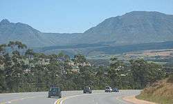
Riversdale (Afrikaans: Riversdal) is a town located on the N2 highway between Cape Town and George on the Agulhas Coastal Plain of the southern Western Cape province of South Africa. It is an agricultural service oriented town, being a hub for shopping and other services for surrounding farming communities, smaller towns, and coastal resorts, like Witsand and Stilbaai. It is located beneath the imposing Langeberg Mountains to the north, with Sleeping Beauty Mountain overlooking the town.
The town was founded as a church on the farm, Doornkraal, and was subsequently named after Harry Rivers, the then incumbent Civil Commissioner of Swellendam. It was proclaimed a town on 30 August 1838. Riverdale is the seat of the Hessequa Local Municipality. It is also sometimes considered the westernmost point in the Garden Route region.
Notable residents
- Dyan Buis, Paralympic Athlete
- JT Jackson, Blue Bulls rugby
- Dr Cecil Moss, Springbok
- Jack Simons, academic and anti-apartheid activist
- Jan Ernst Abraham Volschenk (20 August 1853 Riversdale – 22 January 1936 Riversdale), was a South African painter, noted for his majestic landscapes of the Langeberg Range in the Western Cape Province
- Vera Volschenk (1899-1987) was a South African painter who was born in 1899. Eldest of nine daughters of Jan Ernst Abraham Volschenk[3]
See also
References
| Wikimedia Commons has media related to Riversdale, Western Cape. |
Municipalities and communities of Eden District Municipality, Western Cape | ||
|---|---|---|
District seat: George | ||
| Bitou | .svg.png) | |
| George | ||
| Hessequa | ||
| Kannaland | ||
| Knysna | ||
| Mossel Bay | ||
| Oudtshoorn | ||