River Taf
The River Taf (Welsh: Afon Taf) is a river in West Wales. It rises in the Preseli Hills of north Pembrokeshire and flows approximately 50 km (30 mi) through Carmarthenshire to Carmarthen Bay. It is one of three rivers, along with the River Gwendraeth and River Towy, to enter the sea on the east side of Carmarthen Bay.[1]
Water drains from high ground above the village of Crymych in Pembrokeshire, and at one time flowed at ground level across the main Cardigan–Tenby road (A478) before falling to the level of the defunct Whitland and Cardigan Railway station Crymmych Arms (Great Western Railway) where, on the UK Ordnance Survey map of 1866 it is shown as the source of the Taf.
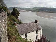
At this point the stream fulfils its description "Crymych" (in Welsh "crooked stream") by turning through almost a right angle along the floor of the valley. The stream is mentioned—with various spellings—in records since 1468 and provided both the village and its hostelry with an identity. From there the Taf, augmented by numerous minor tributaries, flows ESE to Llanfyrnach then SW through Glandŵr, Llanglydwen and Login to Whitland. It then flows east to St Clears, south of which its broad estuary meets Carmarthen Bay near Laugharne. Its length is about 56 km (35 mi) from Crymych to Ginst Point, of which about 14 km (9 mi) is tidal.
| Wikimedia Commons has media related to River Taf. |
References
- ↑ The Journal of Conchology 1979 p 7 "CARMARTHEN BAY. Three large estuaries, the Gwendraeth, Afon Tywi and Afon Taf enter the sea on the east side of Carmarthen Bay and these rivers contribute to deposits of muddy shores.
Coordinates: 51°48′N 4°29′W / 51.800°N 4.483°W