River Rouge, Michigan
| River Rouge, Michigan | |
|---|---|
| City | |
|
City hall | |
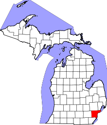
 Location in Wayne County and the state of Michigan | |
| Coordinates: 42°16′17″N 83°8′5″W / 42.27139°N 83.13472°W | |
| Country | United States |
| State | Michigan |
| County | Wayne |
| Incorporated (village) | 1899 |
| Incorporated (city) | 1922 |
| Government | |
| • Mayor | Michael D. Bowdler |
| Area[1] | |
| • Total | 3.24 sq mi (8.39 km2) |
| • Land | 2.65 sq mi (6.86 km2) |
| • Water | 0.59 sq mi (1.53 km2) |
| Elevation | 584 ft (178 m) |
| Population (2010)[2] | |
| • Total | 7,903 |
| • Estimate (2012[3]) | 7,762 |
| • Density | 2,982.3/sq mi (1,151.5/km2) |
| Time zone | EST (UTC-5) |
| • Summer (DST) | EDT (UTC-4) |
| ZIP code | 48218 |
| Area code(s) | 313 |
| FIPS code | 26-68760[4] |
| GNIS feature ID | 0635965[5] |
| Website | http://www.cityofriverrouge.com |
_2.jpg)
River Rouge is a city in Wayne County in the U.S. state of Michigan and an industrial Downriver suburb of Detroit. The population was 7,903 at the 2010 census. It is named after the River Rouge (or Rouge River from the French "rouge" meaning red), which flows along the city's northern border and into the Detroit River. The city includes the heavily industrialized Zug Island at the mouth of the River Rouge.
Geography
According to the United States Census Bureau, the city has a total area of 3.24 square miles (8.39 km2), of which 2.65 square miles (6.86 km2) is land and 0.59 square miles (1.53 km2) is water.[1] Of the land area, 0.93 mi square mile (2.4 km²) consists of Zug Island.
Demographics
| Historical population | |||
|---|---|---|---|
| Census | Pop. | %± | |
| 1900 | 1,748 | — | |
| 1910 | 4,163 | 138.2% | |
| 1920 | 9,822 | 135.9% | |
| 1930 | 17,314 | 76.3% | |
| 1940 | 17,008 | −1.8% | |
| 1950 | 20,549 | 20.8% | |
| 1960 | 18,147 | −11.7% | |
| 1970 | 15,947 | −12.1% | |
| 1980 | 12,912 | −19.0% | |
| 1990 | 11,314 | −12.4% | |
| 2000 | 9,917 | −12.3% | |
| 2010 | 7,903 | −20.3% | |
| Est. 2015 | 7,546 | [6] | −4.5% |
2010 census
As of the census[2] of 2010, there were 7,903 people, 2,897 households, and 1,885 families residing in the city. The population density was 2,982.3 inhabitants per square mile (1,151.5/km2). There were 3,731 housing units at an average density of 1,407.9 per square mile (543.6/km2). The racial makeup of the city was 39.4% White, 50.5% African American, 0.6% Native American, 0.2% Asian, 0.1% Pacific Islander, 4.2% from other races, and 5.0% from two or more races. Hispanic or Latino of any race were 11.2% of the population.
There were 2,897 households of which 37.7% had children under the age of 18 living with them, 25.1% were married couples living together, 32.3% had a female householder with no husband present, 7.6% had a male householder with no wife present, and 34.9% were non-families. 29.5% of all households were made up of individuals and 10.2% had someone living alone who was 65 years of age or older. The average household size was 2.73 and the average family size was 3.37.
The median age in the city was 33 years. 29.2% of residents were under the age of 18; 10.6% were between the ages of 18 and 24; 24.4% were from 25 to 44; 24.7% were from 45 to 64; and 11.2% were 65 years of age or older. The gender makeup of the city was 47.0% male and 53.0% female.
2000 census
As of the census[4] of 2000, there were 9,917 people, 3,640 households, and 2,504 families residing in the city. The population density was 3,713.9 per square mile (1,434.1/km²). There were 4,080 housing units at an average density of 1,528.0 per square mile (590.0/km²). The racial makeup of the city was 52.58% White, 42.01% African American, 0.78% Native American, 0.16% Asian, 0.04% Pacific Islander, 1.63% from other races, and 2.80% from two or more races. Hispanic or Latino of any race were 4.96% of the population.
There were 3,640 households out of which 36.0% had children under the age of 18 living with them, 31.4% were married couples living together, 30.4% had a female householder with no husband present, and 31.2% were non-families. 26.3% of all households were made up of individuals and 8.9% had someone living alone who was 65 years of age or older. The average household size was 2.72 and the average family size was 3.25.
In the city the population was spread out with 31.2% under the age of 18, 10.2% from 18 to 24, 29.2% from 25 to 44, 18.8% from 45 to 64, and 10.6% who were 65 years of age or older. The median age was 31 years. For every 100 females there were 89.4 males. For every 100 females age 18 and over, there were 84.1 males.
The median income for a household in the city was $29,214, and the median income for a family was $33,875. Males had a median income of $35,613 versus $24,391 for females. The per capita income for the city was $13,728. About 19.1% of families and 22.0% of the population were below the poverty line, including 30.6% of those under age 18 and 10.5% of those age 65 or over.
Community resources
A number of community resources exist in River Rouge. These include the Senior Center, Teen Center, Beechwood Center, the Walter White Community Center, the River Rouge Historical Museum and the River Rouge Public Library.
In September 2015, River Rouge was selected by Gov Rick Snyder as one of only 10 "Rising Tide" communities throughout the state, and is scheduled to benefit from the Michigan Department of Talent and Economic Development's ongoing efforts and resources. River Rouge is also seeing a major push into the redevelopment of the existing housing stock, with numerous families and investors attracted to the high demand for quality family housing there.
River Rouge also welcomes major business, and these include local and international presences in steel, lime, petroleum/lubricants/ethanol, recycling/resource recovery, precast concrete manufacturing, shipping and terminals, all located in River Rouge.
Education
River Rouge School District serves River Rouge. Schools include Ann Visger Elementary School, Clarence B. Sabbath Elementary/Middle School, and River Rouge High School.
Gallery
.jpg)
 Visger Elementary School
 River Rouge High School
_2.jpg) Public library
Public library_2.jpg) Post office
Post office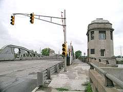 The Bridge
.jpg) River Rouge Post Office.
River Rouge Post Office.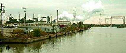 Industrial area along the riverfront of River Rouge.
 Sabbath Middle School
Climate
This climatic region is typified by large seasonal temperature differences, with warm to hot (and often humid) summers and cold (sometimes severely cold) winters. According to the Köppen Climate Classification system, River Rouge has a humid continental climate, abbreviated "Dfb" on climate maps.[8]
Historical Significance
River Rouge has a rich history. One of the most important historical associations with River Rouge is its relationship to the Great Lakes freighter, the SS Edmund Fitzgerald. The ship was constructed at the Great Lakes Engineering Works in River Rouge in 1959.
References
- 1 2 "US Gazetteer files 2010". United States Census Bureau. Retrieved 2012-11-25.
- 1 2 "American FactFinder". United States Census Bureau. Retrieved 2012-11-25.
- ↑ "Population Estimates". United States Census Bureau. Retrieved 2013-06-03.
- 1 2 "American FactFinder". United States Census Bureau. Retrieved 2008-01-31.
- ↑ "US Board on Geographic Names". United States Geological Survey. 2007-10-25. Retrieved 2008-01-31.
- ↑ "Annual Estimates of the Resident Population for Incorporated Places: April 1, 2010 to July 1, 2015". Retrieved July 2, 2016.
- ↑ "Census of Population and Housing". Census.gov. Retrieved June 4, 2015.
- ↑ Climate Summary for River Rouge, Michigan
External links
- City of River Rouge Official Website
- River Rouge Public Library Official Website
- River Rouge School District Official Website
 |
Detroit | Detroit River | | |
| |
Detroit River / | |||
| ||||
| | ||||
| Lincoln Park | Ecorse | Detroit River / |
Municipalities and communities of Wayne County, Michigan, United States | ||
|---|---|---|
| Cities |
|  |
| Charter townships | ||
| General law townships | ||
| Unincorporated community | ||
| Footnotes | ‡This populated place also has portions in an adjacent county or counties | |
| Topics |  | |
|---|---|---|
| Detroit | ||
| Municipalities over 80,000 | ||
| Municipalities 40,000 to 80,000 | ||
| Cultural enclaves | ||
| Satellite cities | ||
| Counties in MSA | ||
| Counties in CSA | ||
Coordinates: 42°16′24″N 83°08′04″W / 42.27333°N 83.13444°W