River Misbourne
Coordinates: 51°42′14″N 0°42′29″W / 51.704°N 0.708°W
| River Misbourne | |
|---|---|
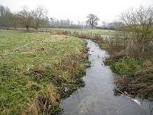 River Misbourne near Chalfont St Giles | |
| Country | England |
| Basin | |
| Main source | nr Great Missenden |
| River mouth | River Colne near Denham |
| River system | Thames |
The River Misbourne rises in a field on the outskirts of Great Missenden, Buckinghamshire, and flows down the Misbourne valley to join the River Colne just north of where the latter is crossed by the A40 Western Avenue.
It passes through Little Missenden, Old Amersham, Chalfont St Giles and Chalfont St Peter, and under the Chiltern railway line and the M25 on its way down the valley. It has for some years had intermittent reduced or stopped flow because of abstraction for supply from the aquifers feeding it. The low flow caused its course to be neglected or partially obstructed, so when the water companies undertook remedial measures which restored the flow there were episodes of flooding in Chalfont St Peter and Chalfont St Giles village centres. Later work has restored the integrity of the course, and no floods have occurred since then.
The river is a 'perch' stream, flowing over a bed of impermeable material on top of a porous substrate. This state is only quasi-stable, since in periods of low rainfall the water table drops below the level of the impermeable layer. If ground works are then carried out which damage this layer, the river can sink into the porous substrate and disappear.
The upper part of the river was dry for over 3 years starting in November 2003 but re-appeared in February 2007 following several months of above-average rainfall which raised the water table.[1]
References
External links
![]() Media related to River Misbourne at Wikimedia Commons
Media related to River Misbourne at Wikimedia Commons
| Non-tributaries | |
|---|---|
| Tributaries | |
| Passing Denham/Iver |
|
| Man-made | |