River Gwaun
| Afon Gwaun | |
| River Gwaun | |
| River | |
| Country | Wales |
|---|---|
| Counties | Pembrokeshire |
| Towns | Fishguard |
| Source | |
| - location | Preseli Hills |
| - coordinates | 51°57′29″N 4°48′15″W / 51.9580°N 4.8043°W |
| Mouth | |
| - location | Fishguard, Pembrokeshire |
| - coordinates | 51°59′45″N 4°58′11″W / 51.9959°N 4.9696°WCoordinates: 51°59′45″N 4°58′11″W / 51.9959°N 4.9696°W |
| Length | 15 km (9 mi) |
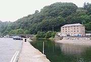
The River Gwaun (Welsh: Afon Gwaun, "Gwaun" meaning 'marsh, moor') is a river in Pembrokeshire, West Wales, which flows principally westwards, through the hamlet of Cwm Gwaun, draining to the sea into Fishguard Bay at Fishguard (Welsh: Abergwaun - 'mouth of the Gwaun').
Course

The Gwaun rises in the Pembrokeshire Coast National Park on the northern slopes of Foel Eryr in the Preseli Hills, to the east of Pontfaen hamlet. The river is a slowly meandering stream passing through marshy, wet woodland with alder trees, water meadows and flood plains. Its river valley is deep and secluded through the Gwaun Valley, past the hamlets of Cwm Gwaun and Llanychaer up to where it meets the sea at Lower Fishguard.
It has a total length of 9 miles (14 km) and is navigable by canoe[1] for the lower third of its length, beginning west of Pontfaen. Before Pontfaen, the river is joined by the Afon Cwmau which flows from the south.
Formation
The river was formed as a meltwater channel for the retreating glaciers at the end of the Ice Age.
References
- ↑ "Afon Gwaun - UK Rivers Guidebook". Retrieved 1 June 2014.
| Wikimedia Commons has media related to River Gwaun. |