Drava
| Drava | |
| Drau, Drave, Dráva | |
| River | |
 Drava near Ormož, Slovenia | |
| Countries | Italy, Austria, Slovenia, Croatia, Hungary |
|---|---|
| Cities | Lienz, Spittal an der Drau, Villach, Ferlach, Dravograd, Vuzenica, Muta, Ruše, Maribor, Ptuj, Ormož, Varaždin, Osijek, Barcs |
| Source | North of the Neunerkogel over the Toblacher Feld |
| - location | Toblach, South Tyrol, Italy |
| - elevation | 1,450 m (4,757 ft) |
| - coordinates | 46°43′9″N 12°15′16″E / 46.71917°N 12.25444°E |
| Mouth | Danube near Osijek |
| - coordinates | 45°32′38″N 18°55′31″E / 45.54389°N 18.92528°ECoordinates: 45°32′38″N 18°55′31″E / 45.54389°N 18.92528°E |
| Length | 749 km (465 mi) |
| Basin | 40,120 km2 (15,490 sq mi) |
| Discharge | |
| - average | 670 m3/s (23,661 cu ft/s) |
 Map of Drava River | |
The Drava[1] (German: Drau; Hungarian: Dráva) or Drave[1] is a river in southern Central Europe. With a length of 749 kilometres (465 mi), it is the fourth longest tributary of the Danube.[2] Its source is near the market town of Innichen (San Candido), in the Puster Valley of South Tyrol, Italy. The river flows eastwards through East Tirol and Carinthia in Austria into the Styria region of Slovenia. It then turns southeast, passing through Croatia and forming most of the border between Croatia and Hungary, before it joins the Danube near Osijek.
Overview
In ancient times the river was known as Latin: Dravus, cf. Sanskrit: द्रवति, dravati, "flow". The name is most likely of Celtic or Illyrian origin (see Old European hydronymy). The river gives its name to the dravite species of tourmaline.
The Drava (along with one of its tributaries, the Slizza) and the Spöl are the only two rivers originating in Italy that belong to the Danube drainage basin. The Gail in Austria, the Meža and Dravinja in Slovenia, and the Bednja in Croatia from the south, as well as the Möll, the Gurk and the Lavant in Austria, and the Mur (near Legrad) in Croatia from the north are its main tributaries.
Course
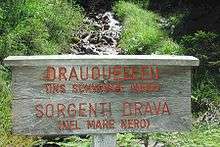
The Drava sources are located at the drainage divide between the market town of Innichen and neighbouring Toblach (Dobbiaco) in the west, where the Rienz river rises, a tributary of the Adige (Etsch). The river flows eastwards and after a few kilometres reaches the border with East Tyrol in Austria. It flows through Lienz and into Carinthia at Oberdrauburg. The river separates the Kreuzeck range of the High Tauern in the north and the Gailtal Alps in the south, passes the Sachsenburg narrows and the site of the ancient city of Teurnia, before it reaches the town of Spittal an der Drau. Downstream of Villach, it runs along the northern slopes of the Karawanks to Ferlach and Lavamünd.
The Drava passes into Slovenia at Dravograd, from where it runs for 142 kilometres (88 mi)[3] via Vuzenica, Muta, Ruše, and Maribor, with a population of about 120,000 the largest city on the Drava, to Ptuj and the border with Croatia at Ormož. The river then passes Varaždin, Belišće and Osijek in Croatia, and Barcs in Hungary. It is navigable for about 90 kilometres (56 mi) from Čađavica in Croatia to its mouth.[3]
The hydrological parameters of Drava are regularly monitored in Croatia at Botovo, Terezino Polje, Donji Miholjac and Osijek.[4]
Hydroelectric power plants
Currently, there are 22 hydroelectric power plants on the Drava. The power plants are listed beginning at the headwaters:
| Dam | Nameplate capacity (MW) | Annual generation (Mio. kwh) |
|---|---|---|
| Amlach[5] | 60 | 219 |
| Paternion[6] | 24 | 95 |
| Kellerberg[6] | 25 | 96 |
| Villach[6] | 25 | 100 |
| Rosegg-St. Jakob[6] | 80 | 338 |
| Feistritz-Ludmannsdorf[6] | 88 | 354 |
| Ferlach-Maria Rain[6] | 75 | 318 |
| Annabrücke[6] | 90 | 390 |
| Edling[6] | 87 | 407 |
| Schwabeck[6] | 79 | 378 |
| Lavamünd[6] | 28 | 156 |
| Dravograd[7] | 26.2 | 142 |
| Vuzenica[7] | 55.6 | 247 |
| Vuhred[7] | 72.3 | 297 |
| Ožbalt[7] | 73.2 | 305 |
| Fala[7] | 58 | 260 |
| Mariborski Otok[7] | 60 | 270 |
| Zlatoličje[7] | 126 | 577 |
| Formin[7] | 116 | 548 |
| Varaždin | 86 | 476 |
| Čakovec | 75.9 | 400 |
| Dubrava | 84 | |
External links
| Wikimedia Commons has media related to Drava. |
- DrauDrava - old river and new sounds
- Condition of Drava in various locations in Slovenia:
- Črneče - graphs, in the following order, of water level, flow and temperature data for the past 30 days (taken in Črneče by ARSO)
- Ptuj - graphs, in the following order, of water level, flow and temperature data for the past 30 days (taken in Ptuj by ARSO)
- Borl - graphs, in the following order, of water level, flow and temperature data for the past 30 days (taken in Borl by ARSO)
Hydrography of Slovenia | ||
|---|---|---|
| Rivers |
|  |
| Streams | ||
| Waterfalls | ||
| Lakes | ||
| Wetlands | ||
| Sea | ||
| River valleys |
| |
| Canyons and gorges |
| |
| Countries |  | |
|---|---|---|
| Cities | ||
| Tributaries | ||
| See also | ||
References
- 1 2 Utrata Fachwörterbuch: Geographie - Englisch-Deutsch/Deutsch-Englisch by Jürgen Utrata (2014). Retrieved 10 Apr 2014.
- ↑ Klement Tockner, Urs Uehlinger, Christopher T. Robinson (2009), Rivers of Europe, Academic Press, no nr., ISBN 978-0-12-369449-2
- 1 2 "Reke, dolge nad 25 km, in njihova padavinska obmocja" [Rivers, longer than 25 km, and their catchment areas] (in Slovenian and English). Statistical Office of the Republic of Slovenia. 2002.
- ↑ "Daily hydrological report". State Hydrometeorological Bureau of the Republic of Croatia. Retrieved 2010-09-09.
- ↑ "Kraftwerk Amlach" (in German). Tiwag. Retrieved 2016-08-25.
- 1 2 3 4 5 6 7 8 9 10 "Die Drau" (in German). Verbund. Retrieved 2016-08-25.
- 1 2 3 4 5 6 7 8 "Power plants". Dravske elektrarne Maribor. Retrieved 2016-08-25.