River Ash, Surrey
| River Ash | |
| River | |
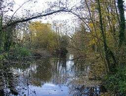 Reach with wider banks, reeds and woodland close to Shepperton Studios | |
| Country | United Kingdom |
|---|---|
| Region | England |
| City | Shepperton,Coordinates: 51°24′25″N 0°28′08″W / 51.407°N 0.469°W Ashford, Staines-upon-Thames |
| Source | River Colne |
| - location | Staines-upon-Thames, Spelthorne, England, United Kingdom |
| Mouth | River Thames |
| - location | Lower Sunbury, Spelthorne, England, United Kingdom |
| Length | 10 km (6 mi) |
The River Ash is a small, shallow river in Surrey, England and its course of 10 km or 6 miles is just outside Greater London. Work has been carried out to straighten, sluice control, dredge and hem in sections over centuries. It flows as one of the seven present distributaries of the River Colne from just south of Staines Moor by the M25 motorway eastwards through the rest of the borough of Spelthorne before meeting the River Thames. It is not navigable to craft and is rich in plant and insects, particularly reeds and butterflies.
Course
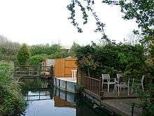
The river is a distributary of the River Colne forming the traditional boundary of Staines-upon-Thames first with Stanwell then with Ashford.[n 1] It then from eastward turns southward and forms the boundary of Littleton (specifically the Queen Mary Reservoir followed by Shepperton Studios) on its east then north bank. On the other bank is Laleham where it turns eastward for the rest of its course - however for almost 1 mile (1.6 km) the south bank becomes Shepperton Green which is developed right up to the urban/suburban re-centred and retracted village of Littleton on the north bank. The large Sunbury Golf Course in Upper Halliford, then a rural Green Belt part of Sunbury-on-Thames proper replace its north bank. In the far east of Shepperton it joins the River Thames, flowing gently into the Creek, (a secondary weirstream of the Thames) facing a long residential island named Wheatley's Ait.[1] It is privately owned and forms a feature in parks, farms and end of gardens.[2] The five urban centres in the borough are a minimum of 500m from the river and three parks make use of the river for walks, the longest of which is in Fordbridge Park, Ashford. Being otherwise private, even experienced canoeists do not travel the river/stream given its reedier sections, short barrages and upper culverts.
Flow
In terms of flow of the seven distributaries, it is mid-ranked, ahead of Sweeps Ditch, Staines, and the long but ornamental Duke of Northumberland's the Longford Rivers, usually.[n 2]
It is below the size of the short final main River Colne channel itself, the Colne Brook and the River Wraysbury which just rejoins the trunk of the Colne tens of metres from the Thames so is (arguably) the seventh distributary.
Soil divide and water characteristics
Alluvium on gravel (with London Clay outcrops, such as Harrow on the Hill, Hampstead Heath and the Hertfordshire border hills) is the soil profile of the north bank, west of the City of London as far as the Chiltern Hills.[3] As to topsoil the river marks a divide between permeable shallow gravelly topsoil for many miles to the north and almost impermeable alluvium to the south. A very thin, agriculturally prosperous alluvial belt by the River Thames 0.6 miles (0.97 km) to 3 miles (4.8 km) away was caused by deposition from seasonal floods.[4] This prevents for 6 miles the rivers joining despite their proximity. As the gravel former terraces of the Thames slope from north to south lowering the water table as far as the more clay-rich parts of the north, the Ash collects almost all its water from the Colne having no springs of its own, and having a bed largely divorcing it from the rise and fall of the Thames Basin's water table. Water quality is good despite the effluent treatment works along the Colne and for a slow-flowing river eutrophication and depostion is moderate to low.
History
Ashford gains its name from the river, forming the southern boundary of all but its eastern, former common land part. Maps featuring the Ash date to medieval times, thus documenting the artificial changes to the course of the shallow river. The earliest one shows the history of various courses by the Shepperton Studios site in Littleton, a map commissioned by Shepperton Manor two miles to the south.[5] This refers to the monks of Westminster, who, it is suggested, may have done the widening here still visible today, including into pools at points.[6]
In 1910 the Metropolitan Water Board roughly followed its course when building the Staines Aqueduct to supply water from the River Thames at Hythe End to its works at Sunbury and Hampton. Its works conveyed the river in a culvert 'siphon channel' beneath/above the aqueduct at three locations: Birch Green, Shortwood Allotments and West of Queen Mary Reservoir at Laleham.
Shortly after this, the mid-course was shifted a little west to make way for the Queen Mary Reservoir in Littleton. An initial trace of the original course is visible near the reservoir's Intake and Pumping Station.
In the early 1960s, the River Ash outflow from the River Colne was moved south and, eastward; 100 metres of its length was diverted to make way for the Staines Bypass (the A30) where it flows underground for 270 metres beneath the Crooked Billet roundabout.[7]
1947 Flood
The most recent serious flood on the River Ash was in 2014, with the previous being in 1947[n 3] when homes and roads were severely affected by significant inland flooding in this part of England. This was not due to the flood prevention methods on the River Ash but to those on the River Colne, as well as high water levels on the River Thames.
The 2014 flood was also due to high waters in the Thames and Coln. After two years of a promised investigation the local council stopped before actually starting, due to limited powers to investigate private companies and out of date records
Flood risk alleviation
More work has been carried out under the River Ash Flood Alleviation Scheme. An upgrade of the fresh water treatment works at Ashford Common (1994—1995) by Thames Water Utilities resulted in an increased steady outflow and flood risk at properties abutting the lowest part, as the works discharges to the lower River Ash near the M3, when river levels are highest. Consequently, a flood relief channel was suggested. This was built during the first five months in 1995 and cost £450,000.
Notes and references
- Notes
- ↑ In the parish system.
- ↑ The Duke of Northumberland's River was not only used for its current garden lake feature use in Syon Park but also to top up the River Crane for the Shot Tower gunpowder mills, then in Hounslow Heath from the late 16th to late 18th centuries.
- ↑ See also, for example 1947 floods of the River Mole/River Ember
- References
- ↑ Grid square map TQ1068 Ordnance survey website
- ↑ Grid square map TQ0968 Ordnance survey website
- ↑ Robbins, Michael (2003) [1953]. Middlesex. Chichester: Phillimore. ISBN 9781860772696.
- ↑ Natural England - Geodiversity
- ↑ William Page (Editor) (1911). "Spelthorne Hundred: Littleton". A History of the County of Middlesex: Volume 2: General; Ashford, East Bedfont with Hatton, Feltham, Hampton with Hampton Wick, Hanworth, Laleham, Littleton. Institute of Historical Research. Retrieved 15 June 2013.
- ↑ Grid square map TQ0768 Ordnance survey website
- ↑ Grid square map TQ0472 Ordnance survey website
See also
| Next confluence upstream | River Thames | Next confluence downstream |
| River Wey (south) | River Ash, Surrey | Longford River (north) |