Rio Vista, California
| City of Rio Vista | |
|---|---|
| City | |
| Motto: The Gateway to the Delta | |
 Location in Solano County and the state of California | |
 City of Rio Vista Location in the United States | |
| Coordinates: 38°9′50″N 121°41′45″W / 38.16389°N 121.69583°WCoordinates: 38°9′50″N 121°41′45″W / 38.16389°N 121.69583°W | |
| Country |
|
| State |
|
| County | Solano |
| Incorporated | January 6, 1894[1] |
| Government | |
| • State senator | Bill Dodd (D)[2] |
| • Assemblymember | Jim Frazier (D)[2] |
| • U. S. rep. | John Garamendi (D)[3] |
| Area[4] | |
| • Total | 7.094 sq mi (18.375 km2) |
| • Land | 6.691 sq mi (17.330 km2) |
| • Water | 0.403 sq mi (1.044 km2) 5.68% |
| Elevation[5] | 20 ft (6 m) |
| Population (April 1, 2010)[6] | |
| • Total | 7,360 |
| • Estimate (2013)[6] | 7,736 |
| Time zone | Pacific (UTC-8) |
| • Summer (DST) | PDT (UTC-7) |
| ZIP code | 94571 |
| Area code | 707 |
| FIPS code | 06-60984 |
| GNIS feature IDs | 277585, 2410955 |
| Website |
www |
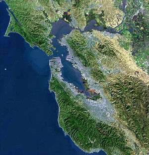
Rio Vista is a city located in the eastern end of Solano County, California, in the San Francisco Bay Area—either in the East Bay or the North Bay, depending on what definition is used—on the Sacramento River, in the Sacramento River Delta region.[7] The population was 7,360 at the 2010 census.
Geography
Rio Vista is approximately 60 miles (100 kilometers) northeast of San Francisco, on the Sacramento River in the Sacramento River Delta.
According to the United States Census Bureau, the city has a total area of 7.1 square miles (18 km2), of which, 6.7 square miles (17 km2) of it is land and 0.4 square miles (1.0 km2) of it (5.68%) is water.
Climate
According to the Köppen Climate Classification system, Rio Vista has a warm-summer Mediterranean climate, abbreviated "Csa" on climate maps.[8]
History
The present location of Rio Vista is several miles south of the original settlement. Colonel Nathan H. Davis founded "Brazos del Rio" near the entrance of Cache Slough at the Sacramento River, on the Rancho Los Ulpinos Mexican land grant, in 1858. The settlement was renamed "Rio Vista" before a flood in 1862 that resulted in the town moving to its present location on higher ground. The city's name combines the Spanish words for "river" and "view." Post authorities established office in 1858.[9] The community was officially incorporated as Rio Vista on December 30, 1893. The newspaper of record there is the River News-Herald and Isleton Journal,[10] established in 1890.[11]
From 1911 through 1992 Rio Vista was home to the United States Army Reserve Center, Rio Vista. The facility was initially established as a base for river control activities by the U.S. Army Corps of Engineers. During the 1950s it was used by the U.S. Army Transportation Corps to store and maintain harbor craft, and during the 1960s and 1970s it was used to prepare amphibious vehicles for transportation to Vietnam and to train troops in their use. In 1980 it was transferred to the U.S. Army Reserve and in 1992 it was closed due to a BRAC decision. The town also hosts a United States Coast Guard station, established in 1963.[12]
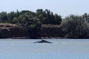
Rio Vista was visited by a lost humpback whale in 1985, despite being 60 miles (100 kilometers) upriver from the Pacific Ocean. The young whale, nicknamed "Humphrey", attracted throngs of curiosity seekers before he was eventually guided back to sea by rescuers. Again in May 2007, humpbacks were sighted in Rio Vista. "Delta" and "Dawn," mother and calf, stopped at least twice in the river near the town.
Demographics
| Historical population | |||
|---|---|---|---|
| Census | Pop. | %± | |
| 1870 | 319 | — | |
| 1880 | 666 | 108.8% | |
| 1890 | 648 | −2.7% | |
| 1900 | 682 | 5.2% | |
| 1910 | 884 | 29.6% | |
| 1920 | 1,104 | 24.9% | |
| 1930 | 1,309 | 18.6% | |
| 1940 | 1,666 | 27.3% | |
| 1950 | 1,831 | 9.9% | |
| 1960 | 2,616 | 42.9% | |
| 1970 | 3,135 | 19.8% | |
| 1980 | 3,142 | 0.2% | |
| 1990 | 3,316 | 5.5% | |
| 2000 | 4,571 | 37.8% | |
| 2010 | 7,360 | 61.0% | |
| Est. 2015 | 8,348 | [13] | 13.4% |
2010
The 2010 United States Census[15] reported that Rio Vista had a population of 7,360. The population density was 1,037.4 people per square mile (400.6/km²). The racial makeup of Rio Vista was 6,003 (81.6%) White, 372 (5.1%) African American, 53 (0.7%) Native American, 359 (4.9%) Asian, 15 (0.2%) Pacific Islander, 288 (3.9%) from other races, and 270 (3.7%) from two or more races. Hispanic or Latino of any race were 914 persons (12.4%).
The Census reported that 100% of the population lived in households.
There were 3,454 households, out of which 626 (18.1%) had children under the age of 18 living in them, 1,846 (53.4%) were opposite-sex married couples living together, 255 (7.4%) had a female householder with no husband present, 139 (4.0%) had a male householder with no wife present. There were 146 (4.2%) unmarried opposite-sex partnerships, and 24 (0.7%) same-sex married couples or partnerships. 1,045 households (30.3%) were made up of individuals and 605 (17.5%) had someone living alone who was 65 years of age or older. The average household size was 2.13. There were 2,240 families (64.9% of all households); the average family size was 2.60.
The population was spread out with 1,145 people (15.6%) under the age of 18, 349 people (4.7%) aged 18 to 24, 1,089 people (14.8%) aged 25 to 44, 2,400 people (32.6%) aged 45 to 64, and 2,377 people (32.3%) who were 65 years of age or older. The median age was 57.2 years. For every 100 females there were 92.6 males. For every 100 females age 18 and over, there were 91.3 males.
There were 3,890 housing units at an average density of 548.3 per square mile (211.7/km²), of which 77.7% were owner-occupied and 22.3% were occupied by renters. The homeowner vacancy rate was 2.7%; the rental vacancy rate was 13.7%. 75.1% of the population lived in owner-occupied housing units and 24.9% lived in rental housing units.
2007
As of 2007, there were 7,876 people, 1,881 households, and 1,286 families residing in the city. The population is predicted to be 22,000 by 2020. The population density was 676.9 people per square mile (261.5/km²). There were 1,974 housing units at an average density of 292.3 per square mile (112.9/km²). The racial makeup of the city was 88.34% White, 1.18% African American, 0.92% Native American, 1.60% Asian, 0.02% Pacific Islander, 4.09% from other races, and 3.85% from two or more races. Hispanic or Latino of any race were 11.42% of the population.
There were 1,881 households, out of which 29.0% had children under the age of 18 living with them, 55.9% were married couples living together, 8.7% had a female householder with no husband present, and 31.6% were non-families. 26.4% of all households were made up of individuals and 13.9% had someone living alone who was 65 years of age or older. The average household size was 2.43 and the average family size was 2.92.
In the city the population was spread out with 25.0% under the age of 18, 6.1% from 18 to 24, 25.6% from 25 to 44, 23.6% from 45 to 64, and 19.7% who were 65 years of age or older. The median age was 41 years. For every 100 females there were 95.4 males. For every 100 females age 18 and over, there were 92.4 males.
The median income for a household in the city was $44,534, and the median income for a family was $52,007. Males had a median income of $43,458 versus $28,665 for females. The per capita income for the city was $24,627. About 6.6% of families and 10.2% of the population were below the poverty line, including 17.7% of those under age 18 and 2.5% of those age 65 or over.
The Trilogy at Rio Vista development, aimed at active adults, is a mile northwest of the original city on the Rio Vista Highway (SR 12). It is built around the 18-hole Rio Vista Golf Club. There will be between 2,800 and 3,000 homes when Trilogy is complete.

Industry
Natural gas was discovered in the Rio Vista area in 1936[16] and the Rio Vista Field, the largest natural gas field in California, became a major source of employment for the remainder of the 20th century. Other industries include agriculture, manufacturing and tourism. There are over 750 wind turbines belonging to the three renewable energy projects (Shiloh Wind Power Plant, NextEra Energy Resources' High Winds Energy Center and one owned by the Sacramento Municipal Utility District) on the Montezuma Hills, close to the city. There are plans to add an additional 200 wind turbines.
Rio Vista is home to the largest American producer of Belgian Endive[17] in the USA. Craig Breedlove, five-time world land speed record holder, lives and has an engineering facility in the city.
The city is served by Rio Vista Municipal Airport and is situated along the Rio Vista Highway (SR 12) between Fairfield and Lodi. The highway crosses the Sacramento River via the Helen Madere Memorial Bridge, colloquially known as the Rio Vista Bridge.
Local attractions
- Dutra Museum of Dredging[18]
- Locke, California – the oldest surviving California town founded by Chinese immigrants.[19]
- Rio Vista Golf Club
- Rio Vista Museum[20]
- Western Railway Museum – west of Rio Vista on CA-12 in Suisun City.[21]
- Rio Vista is home to the annual Bass Festival in October.
In popular culture
- Rio Vista was mentioned at the end of a 2012 AT&T television commercial in which a man jogs from San Francisco until he gets lost, then the GPS on his phone tells him that he is in Rio Vista.[22]
Notable residents
- Craig Breedlove, auto speed record holder
- Bill Wight, Major League Baseball pitcher and scout
See also
References
Notes
- ↑ "California Cities by Incorporation Date" (Word). California Association of Local Agency Formation Commissions. Retrieved August 25, 2014.
- 1 2 "Statewide Database". Regents of the University of California. Retrieved April 17, 2015.
- ↑ "California's 3rd Congressional District - Representatives & District Map". Civic Impulse, LLC. Retrieved February 28, 2013.
- ↑ "2010 Census U.S. Gazetteer Files – Places – California". United States Census Bureau.
- ↑ "Rio Vista". Geographic Names Information System. United States Geological Survey. Retrieved April 17, 2015.
- 1 2 "Rio Vista (city) QuickFacts". United States Census Bureau. Retrieved April 17, 2015.
- ↑ The City of Rio Vista Website, retrieved on July 26, 2008
- ↑ Climate Summary for Rio Vista, California
- ↑ Place-Names of the San Francisco Bay Area, David L. Durham, ISBN 1-884995-35-7
- ↑ Library of Congress
- ↑ River News Herald
- ↑ Pezzaglia, Phil (May 4, 2011). "Exploring Rio Vista's Past: Local Military Installations Part III". River News Herald. Retrieved 6 August 2014.
- ↑ "Annual Estimates of the Resident Population for Incorporated Places: April 1, 2010 to July 1, 2015". Retrieved July 2, 2016.
- ↑ "Census of Population and Housing". Census.gov. Retrieved June 4, 2015.
- ↑ "2010 Census Interactive Population Search: CA - Rio Vista city". U.S. Census Bureau. Retrieved July 12, 2014.
- ↑ Natural gas was discovered in the Rio Vista area in 1936, Retrieved on July 26, 2008
- ↑ Endive World, retrieved on July 26, 2008
- ↑ Carol Bogart (January 18, 2008). "Rio Vista Museum Traces Family's Dredging History". Daily Republic. Retrieved 2010-09-23.
- ↑ Official Locke, CA website
- ↑ Rio Vista Museum
- ↑ Western Railway Museum
- ↑ "Commercial for HTC One X (2012)". Popisms. Retrieved 31 July 2012.
External links
- Official website
- Rio Vista Chamber of Commerce
- Endive World
- Photo Gallery of Rio Vista and the Sacramento River Delta
- Rio Vista Field
- Rio Vista Municipal Airport
- Trilogy at Rio Vista
 |
Dixon | | ||
| Fairfield Suisun City |
|
Lodi | ||
| ||||
| | ||||
| Antioch |
| Bodies of water |
|  |
|---|---|---|
| Counties | ||
| Major cities | ||
| Cities and towns 100k–250k | ||
| Cities and towns 50k–99k | ||
| Cities and towns 25k-50k | ||
| Cities and towns 10k–25k |
| |
| Sub-regions | ||
Municipalities and communities of Solano County, California, United States | ||
|---|---|---|
| Cities | 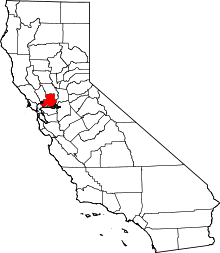 | |
| CDPs | ||
| Unincorporated communities | ||
| Ghost towns |
| |