Rio Tinto (Gondomar)
| Rio Tinto | ||
|---|---|---|
| Parish | ||
| ||
 Rio Tinto | ||
| Coordinates: 41°10′41″N 8°33′36″W / 41.178°N 8.560°WCoordinates: 41°10′41″N 8°33′36″W / 41.178°N 8.560°W | ||
| Country | Portugal | |
| Region | Norte | |
| Subregion | Grande Porto | |
| Metropolitan area | Porto | |
| District | Porto | |
| Municipality | Gondomar | |
| Area | ||
| • Total | 9.38 km2 (3.62 sq mi) | |
| Population (2011) | ||
| • Total | 50,713 | |
| • Density | 5,400/km2 (14,000/sq mi) | |
| Postal code | 4435 | |
| Website | http://www.jf-riotinto.pt/ | |

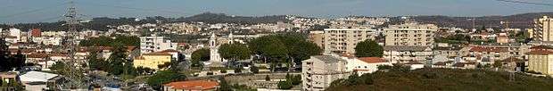
Rio Tinto (Portuguese pronunciation: [ˈʁiu ˈtĩtu]) is a Portuguese city and parish, located in Gondomar Municipality, in northern Portugal. The population in 2011 was 50,713,[1] in an area of 9.38 km².[2] Rio Tinto, which in Portuguese means red river, was elevated to city status in 1995, and the city of Rio Tinto includes two parishes (freguesias): Baguim do Monte and Rio Tinto, with a total of 65,000 inhabitants, being the most populous city in Gondomar municipality, and third largest in the Greater Porto agglomeration.

Church of Rio Tinto
Rio Tinto lies just outside the city of Porto.
Rio Tinto
References
- ↑ Instituto Nacional de Estatística (INE), Census 2011 results according to the 2013 administrative division of Portugal
- ↑ Direção-Geral do Território
Parishes of Gondomar Municipality | ||
|---|---|---|
This article is issued from Wikipedia - version of the 11/7/2015. The text is available under the Creative Commons Attribution/Share Alike but additional terms may apply for the media files.