Riffian, South Tyrol
| Riffian | |
|---|---|
| Comune | |
| Gemeinde Riffian Comune di Rifiano | |
 Riffian Location of Riffian in Italy | |
| Coordinates: 46°42′N 11°11′E / 46.700°N 11.183°ECoordinates: 46°42′N 11°11′E / 46.700°N 11.183°E | |
| Country | Italy |
| Region | Trentino-Alto Adige/Südtirol |
| Province / Metropolitan city | South Tyrol (BZ) |
| Frazioni | Magdfeld, Vernuer (Vernurio) |
| Government | |
| • Mayor | Franz Pixner |
| Area | |
| • Total | 35.8 km2 (13.8 sq mi) |
| Elevation | 504 m (1,654 ft) |
| Population (Nov. 2010) | |
| • Total | 1,306 |
| • Density | 36/km2 (94/sq mi) |
| Demonym(s) |
German: Riffianer Italian: di Rifiano |
| Time zone | CET (UTC+1) |
| • Summer (DST) | CEST (UTC+2) |
| Postal code | 39010 |
| Dialing code | 0473 |
| Website | Official website |
Riffian (German pronunciation: [ˈrɪfɪan]; Italian: Rifiano [riˈfjaːno]) is a comune (municipality) in South Tyrol in northern Italy, located about 25 kilometres (16 mi) northwest of Bolzano.
Geography
As of 30 November 2010, it had a population of 1,306 and an area of 35.8 square kilometres (13.8 sq mi).[1]
Riffian borders the following municipalities: Kuens, Moos in Passeier, St. Leonhard in Passeier, St. Martin in Passeier, Schenna, and Tirol.
Frazioni
The municipality of Riffian contains the frazioni (subdivisions, mainly villages and hamlets) Magdfeld and Vernuer (Vernurio).
History
Coat-of-arms
The emblem represents a bell tower, with the bell box and the onion dome, on azure; it is the symbol of the local church in the village. The emblem was adopted in 1968.[2]
Society
Linguistic distribution
According to the 2011 census, 97.76% of the population speak German, 1.85% Italian and 0.39% Ladin as first language.[3]
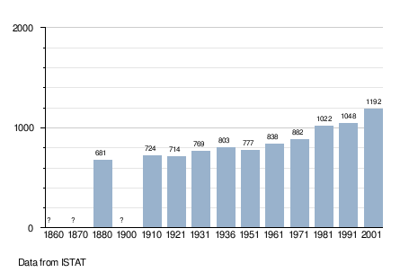
Demographic evolution
References
- ↑ All demographics and other statistics: Italian statistical institute Istat.
- ↑ Heraldry of the World: Riffian
- ↑ "Volkszählung 2011/Censimento della popolazione 2011". astat info. Provincial Statistics Institute of the Autonomous Province of South Tyrol (38): 6–7. June 2012. Retrieved 2012-06-14.
External links
- (German) (Italian) Homepage of the municipality
![]() Media related to Riffian at Wikimedia Commons
Media related to Riffian at Wikimedia Commons