Riegelsville, Pennsylvania
| Borough of Riegelsville | |
| Borough | |
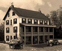
 Signs on the approach for the Riegelsville Bridge denoting entrance into Riegelsville. The Riegelsville Inn can be seen in the background. | |
| Country | United States |
|---|---|
| State | Pennsylvania |
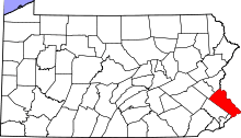
| County | Bucks |
| Elevation | 151 ft (46.0 m) |
| Coordinates | 40°35′44″N 75°11′44″W / 40.59556°N 75.19556°WCoordinates: 40°35′44″N 75°11′44″W / 40.59556°N 75.19556°W |
| Area | 1.0 sq mi (2.6 km2) |
| - land | 1.0 sq mi (3 km2) |
| - water | 0.1 sq mi (0 km2), 10% |
| Population | 868 (2010) |
| Density | 867.8/sq mi (335.1/km2) |
| Mayor | Gregory Stokes |
| Timezone | EST (UTC-5) |
| - summer (DST) | EDT (UTC-4) |
| ZIP Code | 18077 |
| Area code | 610 Exchange: 749 |
 Location of Riegelsville in Bucks County | |
 Location of Riegelsville in Pennsylvania | |
 Location of Pennsylvania in the United States | |
| Website: Riegelsville | |
Riegelsville is a borough in Bucks County, Pennsylvania, United States. The population was 868 at the 2010 census.
History
Benjamin Riegel founded Riegelsville. The original, and now historic, Riegelsville Inn that he built in 1838 still stands. This historic stone inn has offered food and lodging to Bucks County travelers for over 160 years. The community was named for the Riegel family, as early landowners; they established paper mills across the river in New Jersey.
With the completion of the Delaware Canal in 1832, the lands along the Delaware River attracted great industrial development. The movement of coal, a major important product of the area, brought capital & investment to Easton. Boats carried coal, stone, iron, crops and goods from the mills along the 60 miles from Easton to Bristol. Along Canal Street grew one of the largest industrial manufacturing centers of America during the 1830s and 1840s. Easton continued to prosper as a center for industry, manufacturing, commerce, and culture at the Forks of the Delaware and along the great rail lines. Riegelsville prospered when the Delaware Canal opened in 1832 with warehouses and factories lining its banks. The canal closed in 1931 after 99 years of service and was replaced by the railroads. Today, Riegelsville is a peaceful and quiet town. Woods and fields border the Delaware Canal; remnants of crumbling stone foundations along its banks are reminders of a busy past.
Riegelsville, Pennsylvania was a mill town in the late 1880s and 1900s. The borough overlooks the Delaware River spanned by the 1904 the Riegelsville Bridge built by John A. Roebling's Sons, Co. It is one of the approximately three dozen bridges spanning the Delaware River between Pennsylvania and New Jersey.
Residences near the river built by Riegel Paper Company executives in the late 1880s along "Mansions Row" have been restored.
The Benjamin Riegel House was added to the National Register of Historic Places in 1987.[1]
Geography
According to the United States Census Bureau, the borough has a total area of 1.0 square mile (2.6 km2), of which, 1.0 square mile (2.6 km2) of it is land and 0.1 square miles (0.26 km2) of it (5.71%) is water.[2]
Neighboring municipalities
- Durham Township (west and south)
- Holland Township, New Jersey (southeast)
- Pohatcong Township, New Jersey (northeast)
- Williams Township, Northampton County (north)
Demographics
| Historical population | |||
|---|---|---|---|
| Census | Pop. | %± | |
| 1880 | 308 | — | |
| 1920 | 610 | — | |
| 1930 | 725 | 18.9% | |
| 1940 | 824 | 13.7% | |
| 1950 | 871 | 5.7% | |
| 1960 | 953 | 9.4% | |
| 1970 | 1,050 | 10.2% | |
| 1980 | 993 | −5.4% | |
| 1990 | 912 | −8.2% | |
| 2000 | 863 | −5.4% | |
| 2010 | 868 | 0.6% | |
| Est. 2015 | 858 | [3] | −1.2% |
| Sources:[4][5][6] | |||
As of the 2010 census, the borough was 96.8% White, 0.2% Black or African American, 0.3% Native American, 0.2% Asian, and 0.5% were two or more races. 2.0% of the population were of Hispanic or Latino ancestry.[7]
As of the census[5] of 2000, there were 863 people, 378 households, and 250 families residing in the borough. The population density was 867.8 people per square mile (336.6/km²). There were 403 housing units at an average density of 405.3 per square mile (157.2/km²). The racial makeup of the borough was 99.19% White, 0.12% African American, 0.23% Asian, 0.35% from other races, and 0.12% from two or more races. Hispanic or Latino of any race were 0.58% of the population.
There were 378 households, out of which 26.5% had children under the age of 18 living with them, 51.6% were married couples living together, 10.1% had a female householder with no husband present, and 33.6% were non-families. 28.3% of all households were made up of individuals, and 12.2% had someone living alone who was 65 years of age or older. The average household size was 2.28 and the average family size was 2.77.
In the borough the population was spread out, with 21.3% under the age of 18, 5.2% from 18 to 24, 32.9% from 25 to 44, 25.0% from 45 to 64, and 15.5% who were 65 years of age or older. The median age was 40 years. For every 100 females there were 100.2 males. For every 100 females age 18 and over, there were 93.4 males.
The median income for a household in the borough was $48,194, and the median income for a family was $55,208. Males had a median income of $41,250 versus $31,726 for females. The per capita income for the borough was $24,916. About 2.0% of families and 3.3% of the population were below the poverty line, including 1.2% of those under age 18 and 6.7% of those age 65 or over.
References
- ↑ National Park Service (2010-07-09). "National Register Information System". National Register of Historic Places. National Park Service.
- ↑ "US Gazetteer files: 2010, 2000, and 1990". United States Census Bureau. 2011-02-12. Retrieved 2011-04-23.
- ↑ "Annual Estimates of the Resident Population for Incorporated Places: April 1, 2010 to July 1, 2015". Retrieved July 2, 2016.
- ↑ "Census of Population and Housing". U.S. Census Bureau. Archived from the original on May 11, 2015. Retrieved 11 December 2013.
- 1 2 "American FactFinder". United States Census Bureau. Archived from the original on September 11, 2013. Retrieved 2008-01-31.
- ↑ "Incorporated Places and Minor Civil Divisions Datasets: Subcounty Resident Population Estimates: April 1, 2010 to July 1, 2012". Population Estimates. U.S. Census Bureau. Archived from the original on June 17, 2013. Retrieved 11 December 2013.
- ↑ "Census 2010: Pennsylvania". Usatoday.Com. Retrieved 2013-07-22.
| Wikimedia Commons has media related to Riegelsville, Pennsylvania. |