Richmond Railway Bridge
| Richmond Railway Bridge | |
|---|---|
 Richmond Railway Bridge | |
| Carries | National Rail services operated by South West Trains |
| Crosses | River Thames |
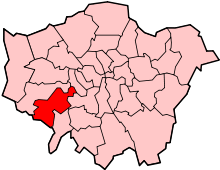
| Locale | Richmond |
| Maintained by | Network Rail |
| Heritage status | Grade II listed structure[1] |
| Characteristics | |
| Design | Truss arch bridge |
| Material | Steel |
| Total length | 91.5 metres[1] |
| Number of spans | 3 |
| History | |
| Designer | Joseph Locke |
| Opened | 1848; rebuilt 1908[1] |
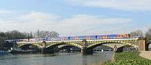
Richmond Railway Bridge in Richmond, south-west London crosses the River Thames immediately upstream of Twickenham Bridge. It carries National Rail services operated by South West Trains on the Waterloo to Reading Line, and lies between Richmond and St. Margarets stations.
After the railway came to Richmond station in 1846, the line was extended to Windsor. Joseph Locke and J E Errington designed the original bridge – and a similar bridge at Barnes – with three 100-foot cast iron girders supported on stone-faced land arches with two stone-faced river piers.[2] Due to concerns over its structural integrity, the bridge was rebuilt in 1908 reusing the existing piers and abutments to a design by the London & South Western Railway's chief engineer, J W Jacomb-Hood.[3] The main bridge girders and decking were replaced in 1984.[4]
The bridge and the approach viaduct, which crosses Richmond's Old Deer Park, was declared a Grade II listed structure in 2008,[1] providing protection to preserve its special character from unsympathetic development.[5]
 Richmond Railway Bridge, Illustrated London News, 21 October 1848
 Richmond Railway Bridge looking downstream with Twickenham Bridge in the background
 Richmond Railway Bridge manufacturer's plaque
 Thames as seen from Richmond Railway Bridge
 Riverside picture including the Richmond Railway Bridge and Asgill House
See also
References
- 1 2 3 4 "Richmond Railway Bridge and Approach Viaduct". National Heritage List for England. English Heritage. Retrieved 28 November 2013.
- ↑ Cherry, Bridget and Pevsner, Nikolaus (1983). The Buildings of England – London 2: South. London: Penguin Books. p. 716. ISBN 0 14 0710 47 7.
- ↑ Addison, Martin. "TQ1774 : Richmond Railway Bridge, River Thames". Geograph. Retrieved 10 November 2012.
- ↑ "Richmond Railway Bridge". Tour UK. Just Tour Ltd. Retrieved 10 February 2013.
- ↑ "London bridges get listed status". BBC News. London. 26 November 2008. Retrieved 13 October 2012.
External links
Coordinates: 51°27′36″N 0°18′49″W / 51.46000°N 0.31361°W