Richmond Hill, Leeds
| Richmond Hill | |
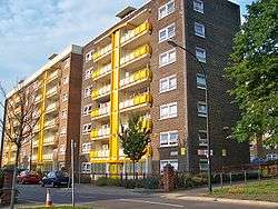 Nos 1-43, The Garth, Saxton Gardens flats |
|
 Richmond Hill |
|
| OS grid reference | SE316334 |
|---|---|
| Metropolitan borough | City of Leeds |
| Metropolitan county | West Yorkshire |
| Region | Yorkshire and the Humber |
| Country | England |
| Sovereign state | United Kingdom |
| Post town | LEEDS |
| Postcode district | LS9 |
| Dialling code | 0113 |
| Police | West Yorkshire |
| Fire | West Yorkshire |
| Ambulance | Yorkshire |
| EU Parliament | Yorkshire and the Humber |
| UK Parliament | Leeds Central, |
Coordinates: 53°47′39″N 1°31′32″W / 53.7943°N 1.5256°W
Richmond Hill is a district of Leeds, West Yorkshire, England. The district lies one mile to the east of the city centre. It lies between York Road (A64 road), East End Park and Cross Green. The appropriate City of Leeds ward is called Burmantofts and Richmond Hill. The area is made up of a variety of different types of buildings and architecture. Since around 2000, the city centre has encroached into the Richmond Hill area.
History
Richmond Hill developed as both a residential and industrial area during the late 18th and 19th centuries. Housing in the area was originally small, individual cottages for local workers, during the industrial revolution however, many streets of back-to-back terrace houses to house many of the industrial workers in the area. Many of these houses still stand, however in the twentieth century much of the housing stock was updated with schemes such as the Saxton Gardens housing scheme. The Saxton Gardens estate has been redeveloped by Urban Splash to create 410 homes, complete with allotments and the largest communal garden in the city. [1]

There are 3 churches in the area. On top of Richmond Hill itself is the Church of England Parish Church of St Saviour (Diocese of Ripon and Leeds), a Grade I listed building from 1845, founded by Edward Bouverie Pusey.[2] Nearby is the now redundant Roman Catholic Church of Mount St Mary's (opened 1857, closed 1989). Mount St Mary's Catholic High School is close to both churches. On the York Road is a small building, All Saints Church built in 1980 to replace an earlier and larger church of the same name.[3]
In May 2012 it was reported that the area has one of the highest teenage pregnancy rates in the United Kingdom, with one in ten girls in the area becoming pregnant by the age of 18.[4]
Amenities
Richmond Hill has limited amenities of its own. The Electrical Engineering department of the Leeds College of Technology is based on East Street in the area. There are local shops throughout the area including off licences, newsagents and fast food takeaways. There is no large supermarket in the area, the nearest being Morrisons in the Merrion Centre and Hunslet.
Transport
Richmond Hill lies close to the Leeds Inner Ring Road, as well as many major routes in and out of the city, this provides the area with many bus routes. Most bus routes are operated by First Leeds. The route 4 bus runs through the area to the city centre, Whinmoor, Seacroft, Gipton, Harehills, St James' Hospital, Wortley, Bramley and Pudsey. The 18 runs to Garforth, Colton, Halton the city centre, Headingley, West Park, Ireland Wood and Tinshill. The 37 runs to Halton Moor, Osmondthorpe and the city centre. The 40 runs to Whinmoor, Swarcliffe, Cross Gates, Halton and the city centre. The 49 runs to Seacroft, Gipton, Harehills, the city centre, Burley, Kirkstall and Bramley. The 50 runs to Seacroft, Oakwood, Harehills, Burley, Kirkstall, Hawksworth and Horsforth. The 56 runs to Whinmoor, Seacroft, Killingbeck, Hyde Park, the University of Leeds, Headingley and Moor Grange. The closest railway station is Leeds railway station, approximately one mile to the west.
Location grid
 |
Burmantofts | | ||
| Leeds city centre | |
East End Park | ||
| ||||
| | ||||
| Cross Green |
References
- ↑ http://www.leodis.net/display.aspx?resourceIdentifier=20031010_91073245&DISPLAY=FULL
- ↑ www.leodis.net St Saviour's Church, Ellerby Lane
- ↑ www.leodis.net All Saints Church, York Road
- ↑ http://www.yorkshireeveningpost.co.uk/news/latest-news/top-stories/shock-rate-of-leeds-teenage-pregnancy-1-4539780
External links
- Leeds Re-generation continues in Richmond Hill - Yorkshire Forward 2006
- "The Ancient Parish of Leeds". GENUKI. Historical and genealogical resource for area including Richmond Hill