Rianila River
| Rianila River | |
| River | |
| Country | |
|---|---|
| Region | Atsinanana |
| City | Brickaville |
| Source | |
| - location | Fahona Massif |
| - elevation | 1,450 m (4,757 ft) |
| Mouth | |
| - location | Andevoranto, Brickaville, Atsinanana |
| - elevation | 0 m (0 ft) |
| - coordinates | MG 18°58′35″S 49°06′10″E / 18.97639°S 49.10278°ECoordinates: MG 18°58′35″S 49°06′10″E / 18.97639°S 49.10278°E |
| Length | 134 km (83 mi) |
| Basin | 7,820 km2 (3,019 sq mi) |
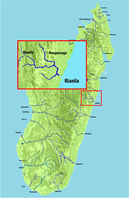 Map of Malagasy rivers. | |
Rianila is a river in the Atsinanana region in eastern Madagascar. It flows down from the central highlands to flow into the Indian Ocean south of Brickaville at Andevoranto. Its largest tributary is the Rongaronga, which joins it near Brickaville.
The river was previously called the Iharoka River by Western explorers (and the Jark River in a few sources).[1]
References
- ↑ History of Madagascar, p. 18 (1838) (example of English source, identifying it as the river just south of Andevoranto)
External links
This article is issued from Wikipedia - version of the 10/16/2016. The text is available under the Creative Commons Attribution/Share Alike but additional terms may apply for the media files.