Rhône Glacier
| Rhône Glacier | |
|---|---|
|
View towards the Tieralplistock | |
| Type | Valley glacier |
| Location | Valais, Switzerland |
| Coordinates | 46°34.32′N 8°22.58′E / 46.57200°N 8.37633°ECoordinates: 46°34.32′N 8°22.58′E / 46.57200°N 8.37633°E |
| Highest elevation | 3630 |
| Lowest elevation | 2200 |
| Terminus | Rotten (Rhone) above Gletsch |
| Status | Retreating |

The Rhône Glacier (German: Rhonegletscher, Walliser German: Rottengletscher, French: le glacier du Rhône) is a glacier in the Swiss Alps and the source of the river Rhône and one of the primary contributors to Lake Geneva in the far eastern end of the Swiss canton of Valais. Because the Glacier is located close to the Furka Pass road it is easily accessible.
Geography
The Rhône Glacier is the largest glacier in the Urner Alps. It lies on the south side of the range at the source of the Rhône. The Undri Triftlimi (3,081 m) connects it to the Trift Glacier. The glacier is located on the northernmost part of the canton of Valais, between the Grimsel Pass and the Furka Pass and is part of the Oberwald municipality. The Dammastock (3,630 m) is the highest summit above the glacier. During most of the past 11,000 years it was smaller than it is now.[1] It is covered each summer in white blankets to try and slow ice loss.[2]
Evolution
 2010
2010 2008
2008 2005
2005 1900
1900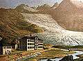 1870
1870

Vertical axis: length difference in meters
Horizontal axis: years
In thick green: cumulated length difference starting 1879
In thin red: growth during one year
The Rhône Glacier is easily accessible so its evolution is observed since the 19th century. The glacier lost ~1300 m during the last 120 years leaving behind a track of naked stone.
See also
References
- Rhône Glacier at Glaciers online
- Rhône Glacier at NASA Earth Observatory
External links
- Simulation of the shrinking of the glacier
- Swiss Glacier Monitoring Network: Rhône Glacier - with length variation measurements since 1879
 Media related to Rhône Glacier at Wikimedia Commons
- Interactive repeat photo comparisons of the Rhône Glacier