Rhode Island Route 103
| ||||
|---|---|---|---|---|
| Route information | ||||
| Maintained by RIDOT | ||||
| Length: | 11.8 mi[1] (19.0 km) | |||
| Existed: | 1923 (truncated 1932) – present | |||
| Major junctions | ||||
| West end: |
| |||
|
| ||||
| East end: |
| |||
| Location | ||||
| Counties: | Providence, Bristol | |||
| Highway system | ||||
| ||||

Route 103 is a numbered State Highway running 11.8 miles (19.0 km) in Rhode Island. It runs from I-195 in East Providence to the Massachusetts state line in the town of Warren, where the road continues as Massachusetts Route 103. Route 103 is a major commercial corridor in East Providence.
Route description
Route 103 begins at the eastbound Exit 5 off-ramp of I-195 in East Providence, running along Warren Avenue until the intersection with Route 114. Route 103 turns south with Route 114 along Pawtucket Avenue, with Route 114 soon separating. Route 103 continues south then veers to the southeast along Willett Avenue as it heads towards the town of Barrington. In Barrington, it continues east as County Road, then meets with and overlaps Route 114 for a second time as the routes cross the Barrington and Palmer rivers into the town of Warren. Route 103 separates from Route 114 along Child Street as it continues east towards the Massachusetts state line, where the road continues as Massachusetts Route 103.
History
Route 103 was an original route assigned in 1923. It used to be much longer, extending 38 miles (61 km) through Providence and along present-day Route 14 to Connecticut, where it used to continue as Route 103. In 1932, Connecticut renumbered its 1920s Route 103 to Route 14. Rhode Island renumbered the portion of Route 103 west of Providence to match the new Connecticut route number.
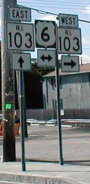
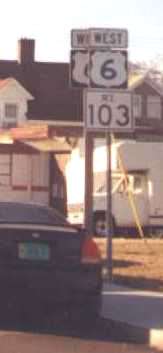
At one time, the main road east from Providence (at first NE 3, now US 6) used Route 103 rather than the current US 6 alignment. Maps disagree on when the change to the current alignment took place. However, rather than using Warren Avenue to the Washington Bridge, the main road continued north on Pawtucket Avenue to Waterman Avenue, and used Waterman Avenue over the old Red Bridge to Providence. When the main road was moved to current US 6, it at first continued to use Waterman Avenue via MA 114A and County Street to the state line.
The current alignment of Route 103 along Warren Avenue in East Providence was also US 6 before Interstate 195 was built. Some signs still mark it as US 6, including some signs placed since 2000.
Major intersections
| County | Location | mi[1] | km | Destinations | Notes |
|---|---|---|---|---|---|
| Providence | East Providence | 0.0 | 0.0 | Western terminus, exit 5 on I-195 / US 6 / US 1A | |
| 0.7 | 1.1 | ||||
| 0.9 | 1.4 | Exit 6 on I-195 | |||
| 1.3 | 2.1 | Western terminus of concurrency with Route 114 | |||
| 2.2 | 3.5 | Eastern terminus of concurrency with Route 114 | |||
| Riverside | 3.7 | 6.0 | West end of Route 103A | ||
| 5.4 | 8.7 | Traffic circle, east end of Route 103A | |||
| Bristol | Barrington | 6.5 | 10.5 | Interchange, u-turn required to exit Route 114 Western terminus of concurrency with Route 114 | |
| Barrington River | 8.8 | 14.2 | Bridge | ||
| Warren | 9.8 | 15.8 | Eastern terminus of concurrency with Route 114 | ||
| 10.4– 10.5 | 16.7– 16.9 | One-way pair | |||
| 11.8 | 19.0 | Continuation into Massachusetts | |||
| 1.000 mi = 1.609 km; 1.000 km = 0.621 mi | |||||
Notes
Westbound traffic at the first split from Route 114 northbound in Barrington must make a U-turn onto Route 114 south and then turn right.
Route 103A is an alternate route through Riverside in southern East Providence; it was never Route 103.
Many maps have incorrectly shown Route 103 using Veterans Memorial Parkway from a bit east of the second Route 114 concurrency to its west end.
References
- 1 2 Google (December 26, 2013). "Route 103" (Map). Google Maps. Google. Retrieved December 26, 2013.