Marne–Rhine Canal
| Marne–Rhine Canal | |
|---|---|
|
The Marne-Rhine Canal at Niderviller, Moselle | |
| Specifications | |
| Length | 313 km (194 mi) [1] |
| Locks | 154 [1] (originally 178 [2]) |
| History | |
| Construction began | 1838 [3] |
| Date completed | 1853 [3] |
| Geography | |
| Start point | Marne in Vitry-le-François [1] |
| End point | Rhine in Strasbourg [1] |
| Beginning coordinates | 48°43′48″N 4°36′24″E / 48.730123°N 4.606670°E |
| Ending coordinates | 48°35′26″N 7°47′16″E / 48.590661°N 7.787779°E |
| Connects to | Rhine, Marne, Meuse River, Moselle River, Canal des houillères de la Sarre |
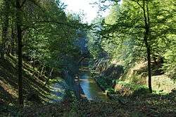

The Marne–Rhine Canal (French: Canal de la Marne au Rhin) is a canal in north eastern France. It connects the river Marne in Vitry-le-François with the Rhine in Strasbourg. Combined with the canalised part of the Marne, it allows transport between Paris and eastern France. The original objective of the canal was to connect Paris and the north of France with the Alsace, the Rhine, and Germany.[3]
Description
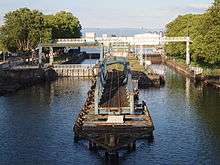
The 313 km (194 mi) long canal was opened in 1853. The canal is suited for small ships (péniches), maximum size 38.5 m long and 5.05 m wide. It has 154 locks, including two in the Moselle River. There are four tunnels. The Saint-Louis-Arzviller inclined plane is located between Arzviller and Saint-Louis and its construction replaced some 17 locks.[3]
The Marne–Rhine Canal is connected with the following navigable waterways (from west to east):
- River Marne in Vitry-le-François
- River Meuse/Canal de l'Est in Sorcy near Commercy [3]
- River Moselle/Canal de l'Est in Toul [3]
- River Moselle in Frouard [3]
- Embranchement de Nancy in Laneuveville-devant-Nancy[3]
- Canal des houillères de la Sarre in Gondrexange [3]
- River Ill in Strasbourg [3]
- Canal du Rhone au Rhine in Strasbourg [3]
- River Rhine in Strasbourg [3]
Its course crosses the following départements and towns:
- Marne: Vitry-le-François
- Meuse: Bar-le-Duc, Ligny-en-Barrois, Void-Vacon
- Meurthe-et-Moselle: Toul, Nancy
- Moselle: Gondrexange, Sarrebourg
- Bas-Rhin: Saverne, Strasbourg
The Voies Navigables France Itinéraires Fluviaux breaks the canal into eastern and western sections. The western sections goes from Vitry-le-François to Toul over 131.4 km (81.6 mi) via 97 locks. The eastern section goes from Frouard to Strasbourg over 159 km (99 mi) via 57 locks.[4] The 23.4 km (14.5 mi) section between Toul and Frouard is closed and a canalized section of the Moselle River is used.[3]
The Through the French Canals book breaks the canal into eastern and western sections, but with a different separation point. The western sections goes from Vitry-le-François to Réchicourt over 222 km (138 mi) via 121 locks. The eastern section goes from Réchicourt to Strasbourg over 91 km (57 mi) via 33 locks.[1]

En Route
See also
References
- 1 2 3 4 5 Jefferson, David (2009). Through the French Canals. Adlard Coles Nautical. p. 275. ISBN 978-1-4081-0381-4.
- ↑ Uhlemann, Hans-Joachim (2002). Canal lifts and inclines of the world (English Translation ed.). Internat. ISBN 0-9543181-1-0.
- 1 2 3 4 5 6 7 8 9 10 11 12 13 McKnight, Hugh (2005). Cruising French Waterways, 4th Edition. Sheridan House. ISBN 978-1574092103.
- ↑ Voies Navigables France Itinéraires Fluviaux. Editions de l'Écluse. 2009. ISBN 978-2-9520591-2-1.
External links
| Wikimedia Commons has media related to Marne-Rhine Canal. |
- Canal de la Marne au Rhin guide Places, ports and moorings on the Marne-Rhine canal - french-waterways.com