Rezovo (river)
| Rezovo River | |
|---|---|
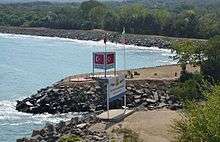 The Bulgarian-Turkish border at the Rezovo River mouth | |
| Native name | Резовска река / Mutludere |
| Country | Turkey, Bulgaria |
| Basin | |
| Main source | Istranca mountain, Turkey |
| River mouth |
Black Sea, Bulgarian-Turkish border 41°58′59″N 28°1′46″E / 41.98306°N 28.02944°ECoordinates: 41°58′59″N 28°1′46″E / 41.98306°N 28.02944°E |
| Basin size | 738 km2 (285 sq mi) |
| Physical characteristics | |
| Length | 112 km (70 mi) |
The Rezovo (also Rezovska, Rezvaya and Rezve; Bulgarian: Резовска река, Rezovska reka; Turkish: Mutludere) is a river in the extreme southeast of Bulgaria and northernmost part of (European) Turkey. The river is situated in Bulgaria's Strandzha Nature Park.
The Rezovo is 112 km long and its source is in the Turkish part of the Strandzha mountains east of Kofçaz under the name of Paspalderesi. It generally flows east and after Paspala becomes a border river between the two countries until its mouth in the Black Sea at Rezovo, which constitutes the southernmost point of the Bulgarian Black Sea Coast and the northernmost point of the Turkish one, as well as the southeasternmost point of Bulgaria and northeasternmost point of Turkish Thrace. The Rezovo's catchment spreads over 738 km², of which 555 km2 are in Turkey. Its largest tributary is the Velika.[1]
The border at the Rezovo's mouth was the subject of a minor territorial dispute between Bulgaria and Turkey, which was settled in the 1990s. As a result of an agreement between the two countries of 6 May 1992 (ratified by Bulgaria in 1998), Bulgaria received a small land area of several square kilometres in the Rezovo Bay in return for water area in the continental shelf.
References and notes
- ↑ "BGGLOBE — Rezovska river". www.bgglobe.net. Retrieved 2008-10-18.
Capital: Malko Tarnovo | ||
| Villages |  | |
| Landmarks |
| |
| Culture | ||
| Notable people | ||
Capital: Tsarevo | ||
| Villages | 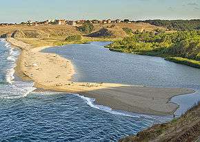 | |
| Landmarks |
| |
| Culture | ||
| Notable people | ||