Reyhan Shahr
"Bab Tangal" redirects here. For the nearby village with that name, see Bab Tangal (village).
| Reyhan Shahr ريحان شهر | |
|---|---|
| city | |
 Reyhan Shahr | |
| Coordinates: 30°54′37″N 56°34′08″E / 30.91028°N 56.56889°ECoordinates: 30°54′37″N 56°34′08″E / 30.91028°N 56.56889°E | |
| Country |
|
| Province | Kerman |
| County | Zarand |
| Bakhsh | Central |
| Population (2006) | |
| • Total | 4,360 |
| Time zone | IRST (UTC+3:30) |
| • Summer (DST) | IRDT (UTC+4:30) |
Reyhan Shahr (Persian: ريحان شهر, also Romanized as Reyhanshahr; formerly, Bab Tangol (Persian: باب تنگل), also Romanized as Bāb Tangol, Bab Tankal, Bab-Tanqal, and Bāb Tangal; also known as Dungal and Eslamabad)[1] is a city in the Central District of Zarand County, Kerman Province, Iran. At the 2006 census, its population was 4,360, in 949 families.[2]
References
- ↑ Reyhan Shahr can be found at GEOnet Names Server, at this link, by opening the Advanced Search box, entering "-3054334" in the "Unique Feature Id" form, and clicking on "Search Database".
- ↑ "Census of the Islamic Republic of Iran, 1385 (2006)". Islamic Republic of Iran. Archived from the original (Excel) on 2011-11-11.
| Capital | 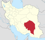 | ||||||||||||||||||||||||||||||||||||||||||||||
|---|---|---|---|---|---|---|---|---|---|---|---|---|---|---|---|---|---|---|---|---|---|---|---|---|---|---|---|---|---|---|---|---|---|---|---|---|---|---|---|---|---|---|---|---|---|---|---|
| Counties (A-L) and cities | |||||||||||||||||||||||||||||||||||||||||||||||
| Counties (M-Z) and cities | |||||||||||||||||||||||||||||||||||||||||||||||
| Sights |
| ||||||||||||||||||||||||||||||||||||||||||||||
| Places | |||||||||||||||||||||||||||||||||||||||||||||||
This article is issued from Wikipedia - version of the 5/30/2013. The text is available under the Creative Commons Attribution/Share Alike but additional terms may apply for the media files.